Geographic information data fusion system

A geographic information data and geographic information technology, applied in the field of data fusion applications, can solve the problems of increasing repetitive construction work, geographic information data redundancy, and the inability to realize data sharing applications, etc., to reduce data maintenance costs and data redundancy Effect

Active Publication Date: 2014-01-22
NO 15 INST OF CHINA ELECTRONICS TECH GRP
View PDF4 Cites 44 Cited by
  • Summary
  • Abstract
  • Description
  • Claims
  • Application Information

AI Technical Summary

Problems solved by technology

[0014] However, in the existing geographic information public service platform, each node at the same level builds geographic information data sources according to its own plan, and the geographic information data formats between parallel nodes may be different from each other, which makes the integration of geographic information data Poor, unable to realize data sharing application, thus increasing duplication of construction work
For example, each node provides different geographic information data sources. Taking the geographic information public service platform Arcgis Server as an example, by installing the database server Oracle, ArcGis Server geographic information data support server, ArcSDE geographic information data management server, and using ArcSDE to establish geographic information Data connection, so as to establish a geographic information data source suitable for its own database and provide ArcSDE geographic information data. Since the format of geographic information is different from that of other geographic information public service platforms, the shared application of geographic information data with other nodes cannot be realized.
That is to say, because different nodes adopt relatively independent geographic information data models and technical protocol standards, such as GML, XML, HTML, etc., a variety of heterogeneous geographic information data formats coexist, making the communication between nodes The geographic information data format is not compatible, and causes the redundancy of geographic information data between nodes, and cannot realize the fusion and sharing application of geographic information data. At the same time, the data source of each node is maintained, and the data maintenance cost is high; further, When users use geographic information data services of different nodes, they need to install corresponding client programs in the client browsers, and call different client programs for different nodes
For example, it is necessary to install the corresponding Java plug-in in the IE browser to analyze the received geographic information data, and the operation is cumbersome

Method used


Image

  • Geographic information data fusion system
  • Geographic information data fusion system
  • Geographic information data fusion system

Examples


Embodiment Construction

[0053] The technical solutions of the embodiments of the present invention will be clearly and completely described below with reference to the accompanying drawings. Obviously, the described embodiments are only a part of the embodiments of the present invention, but not all of the embodiments. Based on the embodiments of the present invention, all other embodiments obtained by those of ordinary skill in the art without creative work fall within the protection scope of the present invention.

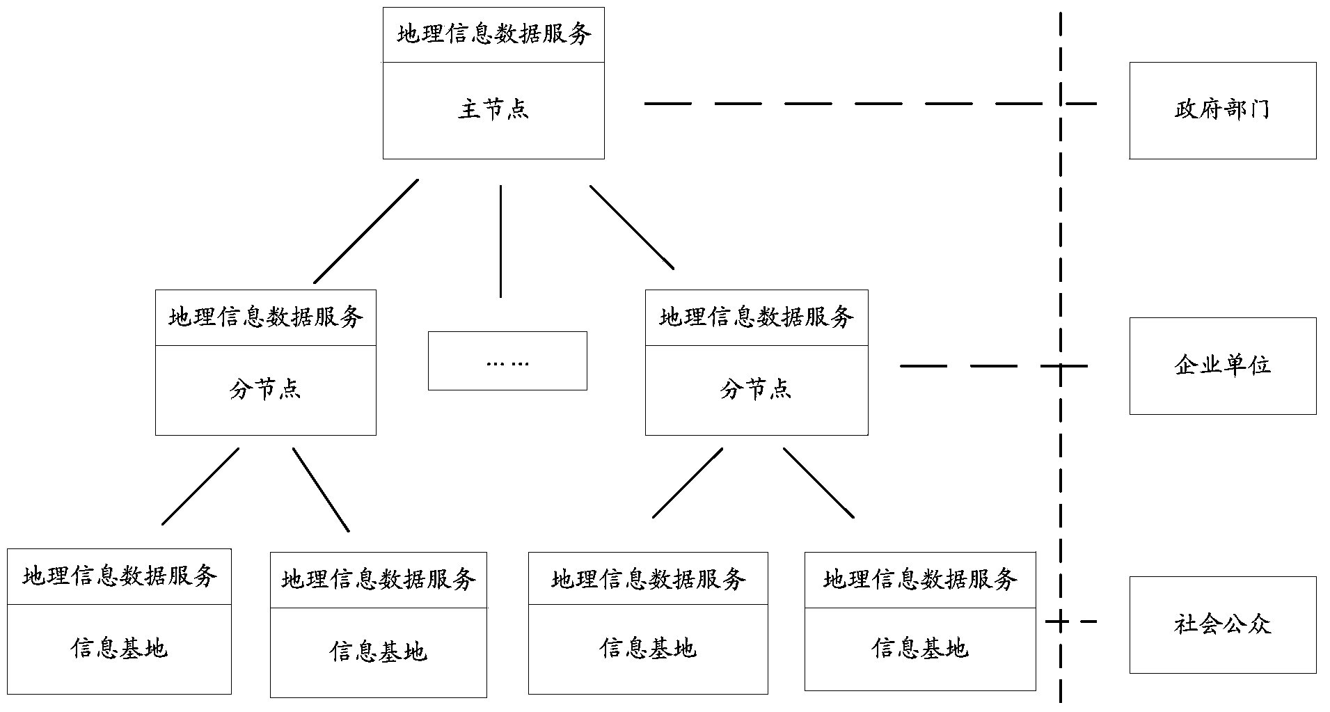
[0054] The sub-nodes and information bases under the existing geographic information public service platform build geographic information data sources according to their own plans. The integration between data resources is poor, and shared applications cannot be realized, so that each node needs to perform data processing. The collection and processing of resources increases the workload of repeated construction and increases the construction cost of the platform; further, it is necessar...


PUM


Abstract

The invention discloses a geographic information data fusion system which comprises a geographic information data interface unit, an information exchange platform unit and an information application front-end processor unit. The geographic information data interface unit is used for classifying and storing input geographic information data according to a geographic information data classification table. The information exchange platform unit is used for reading the geographic information data in the geographic information data interface unit according to a preset refresh cycle, converting the geographic information data into geographic information data in a preset format and outputting the geographic information data. The information application front-end processor unit is used for extracting personal information contained in the geographic information data output by the information exchange platform unit, obtaining activity track information corresponding to the personal information from the geographic information data output from the information exchange platform unit, setting access permissions of the personal information, creating fusion geographic information data containing the access permissions and the personal activity track information, setting personal information identifiers for the fusion geographic information data and storing the fusion geographic information data with the set personal information identifiers. By means of the geographic information data fusion system, data fusion sharing application can be achieved.

Description

technical field [0001] The invention relates to data fusion application technology, in particular to a geographic information data fusion system. Background technique [0002] With the continuous advancement of scientific government management decisions, informatization of national economic and social development, and the construction of a harmonious society, government departments at all levels and the public have an increasing demand for authoritative and reliable geographic information data services. Comprehensive utilization and online service of multi-type geographic information data. Therefore, the construction of a geographic information public service platform that provides geographic information data will be a key development direction of the national surveying and mapping department in the future. [0003] The geographic information public service platform is based on basic geographic information data, with geospatial frame data as the core, and uses modern inform...

Claims


Application Information

Patent Timeline
Patent Type & Authority Applications(China)
IPC IPC(8): G06F17/30
CPCG06F16/29
Inventor 冯卫勇丰国炳张权耿宏宇刘燕伟白思杰李月军张俊铭李冬丽李思昊
Owner NO 15 INST OF CHINA ELECTRONICS TECH GRP
Why Eureka
Try Eureka