Method for improving earth surface shape change monitoring precision of InSAR (Interferometric Synthetic Aperture Radar) technology based on high-precision DEM (Digital Elevation Model)

A surface deformation, high-precision technology, applied in measurement devices, radio wave measurement systems, radio wave reflection/re-radiation, etc.

Inactive Publication Date: 2014-03-26
CHINA AERO GEOPHYSICAL SURVEY & REMOTE SENSING CENT FOR LAND & RESOURCES
View PDF5 Cites 72 Cited by
  • Summary
  • Abstract
  • Description
  • Claims
  • Application Information

AI Technical Summary

Problems solved by technology

[0004] The purpose of the present invention is to solve the problem that the existing method does not consider the error caused by the track baseline and the inaccurate external DEM data, so that the accuracy of the InSAR technology monitoring surface deformation results is not high, and sometimes it is difficult to restore the surface deformation information in a short period of t

Method used


Image

  • Method for improving earth surface shape change monitoring precision of InSAR (Interferometric Synthetic Aperture Radar) technology based on high-precision DEM (Digital Elevation Model)
  • Method for improving earth surface shape change monitoring precision of InSAR (Interferometric Synthetic Aperture Radar) technology based on high-precision DEM (Digital Elevation Model)
  • Method for improving earth surface shape change monitoring precision of InSAR (Interferometric Synthetic Aperture Radar) technology based on high-precision DEM (Digital Elevation Model)

Examples


Embodiment Construction

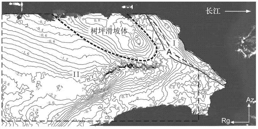
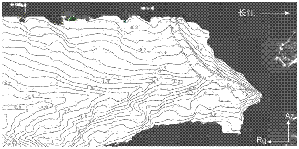
[0057] See accompanying drawing, in order to illustrate method and step of the present invention better, utilize the Shuping landslide area south bank of the Three Gorges Reservoir two sceneries resolution be that the interval time of 1m is the TerraSAR-X radar data of 11 days and the accuracy all is the Lidar number of 1m Taking the elevation model (DEM) data as an example, an experiment was carried out to remove the error phase and recover the deformation information of the sliding area of ​​the Shuping landslide mass.

[0058] (1) The equipment used in the test is a graphics workstation, and the specification model is Dell Precision T7400.

[0059] (2) see figure 1 , the present invention is based on a high-precision DEM method for improving the accuracy of InSAR technology monitoring surface deformation, the specific steps of the method are as follows:

[0060] Step 1: Generate interferograms from radar data

[0061] Based on the traditional differential interferometry m...


PUM


Abstract

The invention discloses a method for improving earth surface shape change monitoring precision of an InSAR (Interferometric Synthetic Aperture Radar) technology based on a high-precision DEM (Digital Elevation Model). The method comprises five steps below: step 1, generating an interferogram by using radar data; step 2, generating a differential interference phase diagram; step 3, establishing error phases and performing feature analysis; step 4, establishing an error phase optimal function calibration model; step 5, recovering earth surface shape change information of a monitoring region based on results of steps 2 and 4. According to the invention, the error phases and elevation values or the error phases, the elevations and coordinate values along a distance/azimuth of different regions of a research region are extracted, the optimal function calibration models of the error phases of corresponding regions are established respectively based on a least square method, and a simulative error phase is finally removed from the differential interference phase diagram to further recover shape change information along a direction of a sight line of a radar in the monitoring region. The method for improving the earth surface shape change monitoring precision of the InSAR technology based on the high-precision DEM has practical value and wide application foreground in the application field of a satellite borne synthetic aperture radar monitoring technology for earth surface shape change.

Description

technical field [0001] The invention relates to a method for improving the precision of surface deformation monitoring by synthetic aperture radar interferometry (InSAR) technology based on high-precision digital elevation model (DEM), which belongs to the technical field of space-borne synthetic aperture radar monitoring surface deformation. Based on the radar data and external high-precision DEM, according to a certain functional relationship between the error phase and the elevation of the study area, the optimal error phase correction model of the study area is established, and the deformation information of the ground target in the study area along the radar line of sight is restored, thereby further Improve the ability of InSAR technology to monitor surface deformation. Background technique [0002] The core of InSAR technology monitoring surface deformation is to restore the geometric and deformation characteristics of ground monitoring targets by obtaining the phase ...

Claims


Application Information

Patent Timeline
IPC IPC(8): G01S7/41G01S7/36G01S13/90
CPCG01S7/414G01S13/9023G01S13/935
Inventor 李曼夏耶张玲郭小方葛大庆王艳
Owner CHINA AERO GEOPHYSICAL SURVEY & REMOTE SENSING CENT FOR LAND & RESOURCES
Why Eureka
Try Eureka