
Unmanned aerial vehicle route planning method based on Dubins route and sparse A* searching

A track planning and unmanned aerial vehicle technology, applied in the direction of position/direction control, vehicle position/route/altitude control, non-electric variable control, etc., can solve problems affecting the efficiency of track planning, reduce time-consuming, improve Efficiency, the effect of reducing the number of nodes

Active Publication Date: 2014-03-26
BEIJING INSTITUTE OF TECHNOLOGYGY
View PDF8 Cites 52 Cited by
  • Summary
  • Abstract
  • Description
  • Claims
  • Application Information

AI Technical Summary

Problems solved by technology

However, the sparse A* search algorithm uses the straight-line distance between the node and the target position as the heuristic function (also called the estimated cost) during the search process, which is inaccurate for the flight path with kinematic constraints such as the minimum turning radius, so although the standard The sparse A* search algorithm can realize the trajectory planning of UAVs, but there are a large number of invalid search nodes in the algorithm, which affects the efficiency of trajectory planning

Method used


Image

  • Unmanned aerial vehicle route planning method based on Dubins route and sparse A* searching
  • Unmanned aerial vehicle route planning method based on Dubins route and sparse A* searching
  • Unmanned aerial vehicle route planning method based on Dubins route and sparse A* searching

Examples


Embodiment

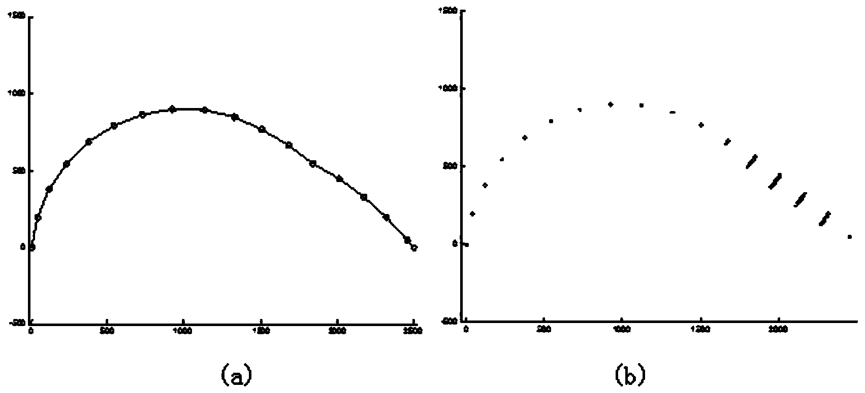
[0078] (1) Example of UAV track planning in barrier-free environment

[0079] The relevant parameters in the example are: UAV flight speed V is 100m / s, the minimum turning radius R is 1km, the shortest direct flight distance (that is, the step size d) is 200m, the maximum turning angle is 11.26°, and the fan shape when the node expands The number of space divisions N is set to 5.

[0080] First, initialize the environment of UAV track planning, including setting the initial position, initial direction angle and target position of the UAV. In this example, the starting point of the UAV is at the origin (0, 0), and the initial flight direction angle is 90°, the coordinates of the target point are (2500, 0).

[0081] Then, use the fast track planning method based on Dubins path and sparse A* search algorithm described in the present invention to plan the optimal track from the starting point to the target for the unmanned aerial vehicle, the track result of planning is as follow...


PUM


Abstract

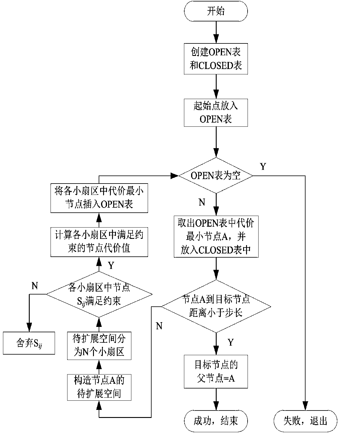
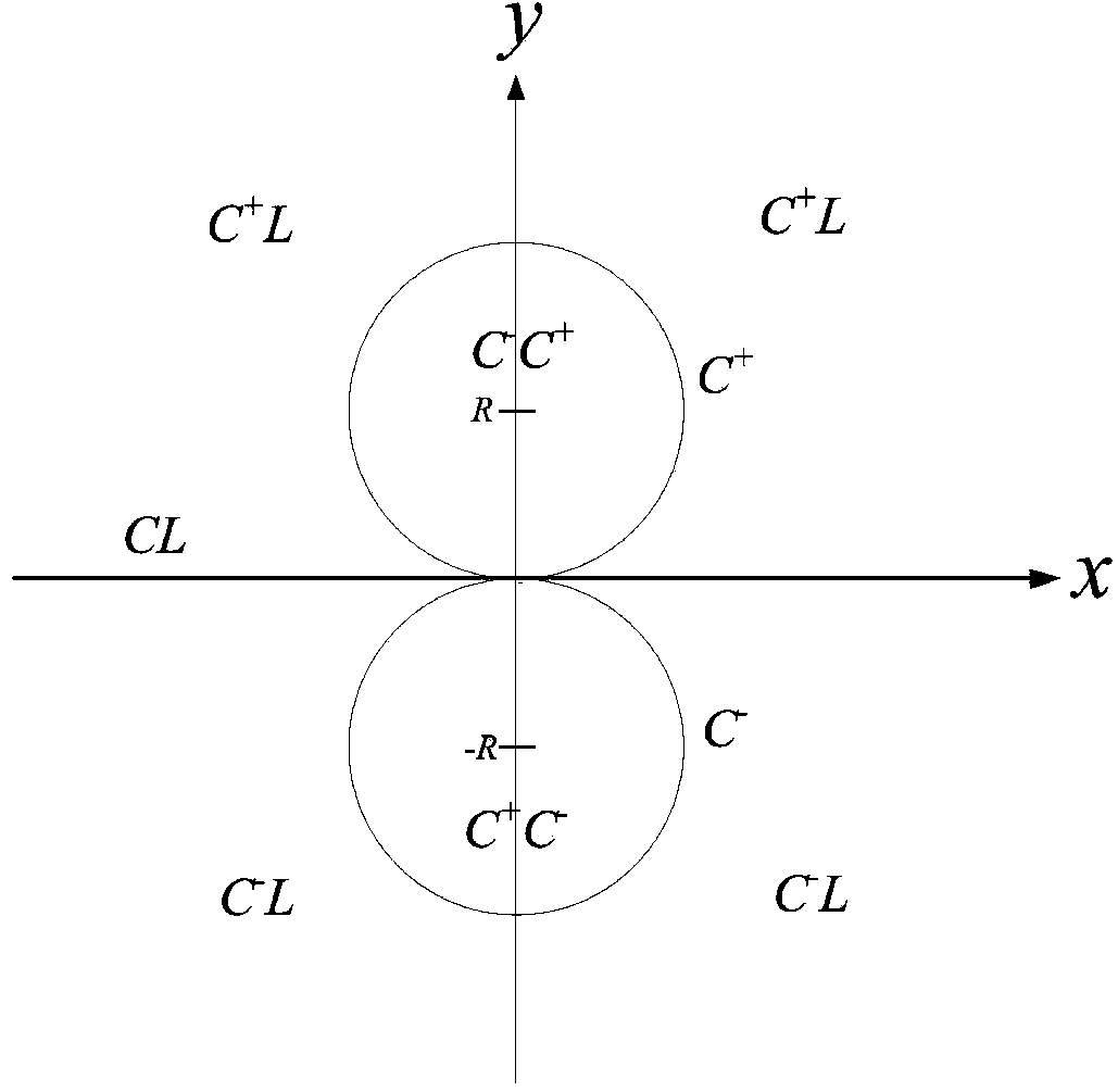
The invention relates to an unmanned aerial vehicle route planning method based on a Dubins route and sparse A* searching (the method is called a Dubins-SAS route planning method for short), and belongs to the technical field of route autonomous planning. According to the method, the Dubins route and a sparse A* searching algorithm are combined, Dubins route length is used as a heuristic function of the sparse A* searching algorithm, the heuristic function is used for searching a space for nodes, and unmanned aerial vehicle route planning is achieved. The distance between the nodes can be estimated accurately, the accuracy of the heuristic function (also called heuristic function cost) is improved, the number of the nodes needed for expanding for completing route searching can be reduced, then route planning time is shortened, and unmanned aerial vehicle route planning efficiency is improved.

Description

technical field [0001] The invention relates to a UAV track planning method based on Dubins path and sparse A* search (Dubins-SAS track planning method for short), which belongs to the technical field of track autonomous planning. Background technique [0002] Unmanned Aerial Vehicle (UAV) is the abbreviation of Unmanned Aerial Vehicles, which is a reusable aircraft driven by power, unmanned on board. Compared with manned aircraft, it has the advantages of small size, low cost, convenient use, low requirements for the combat environment, and strong battlefield survivability, making it more suitable for boring, harsh, dangerous (Dull, Dirty, or Dangerous) task. Under the promotion of science and technology and the traction of combat needs, unmanned aircraft has gradually become the focus of the development of weapons and equipment in various countries, and plays an increasingly important role in warfare. [0003] As an important function of the mission planning subsystem in...

Claims


Application Information

Patent Timeline
IPC IPC(8): G05D1/00
Inventor 刘莉王祝龙腾张晓辉寇家勋于成龙
Owner BEIJING INSTITUTE OF TECHNOLOGYGY
Learn More