Vector data concurrent conversion method from VCT file to shapefile file

A conversion method and vector data technology, applied in the field of parallel conversion of vector data, can solve the problems of inability to realize rapid conversion of large-scale geographic data, and no large-scale VCT data application solution has been proposed, and achieve fast and effective index construction and good versatility. , the effect of improving the efficiency of use

Inactive Publication Date: 2014-03-26
NANJING UNIV
View PDF2 Cites 22 Cited by
  • Summary
  • Abstract
  • Description
  • Claims
  • Application Information

AI Technical Summary

Problems solved by technology

[0009] However, with the increasing complexity and mass of geographic data, none of the above studies has proposed a solution for the application of large-scale VCT data.
In addition, the above commercial GIS software and VCT data format conversion research is mostly aimed at the serial environment. With the increasing complexity and mass of geographic data, this method has been unable to achieve rapid conversion of large-scale geographic data

Method used


Image

  • Vector data concurrent conversion method from VCT file to shapefile file
  • Vector data concurrent conversion method from VCT file to shapefile file
  • Vector data concurrent conversion method from VCT file to shapefile file

Examples


Embodiment

[0047] This embodiment adopts the standard C++ programming language to develop under the Microsoft Visual Studio 2010 development platform, and realizes under the MPI (Message Passing Interface) parallel environment, and the read and write operation of the shapefile is realized through the open-source geographic data format conversion class library GDAL.

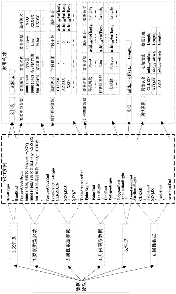
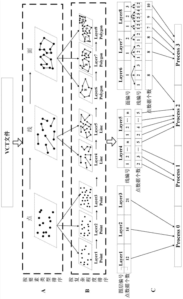
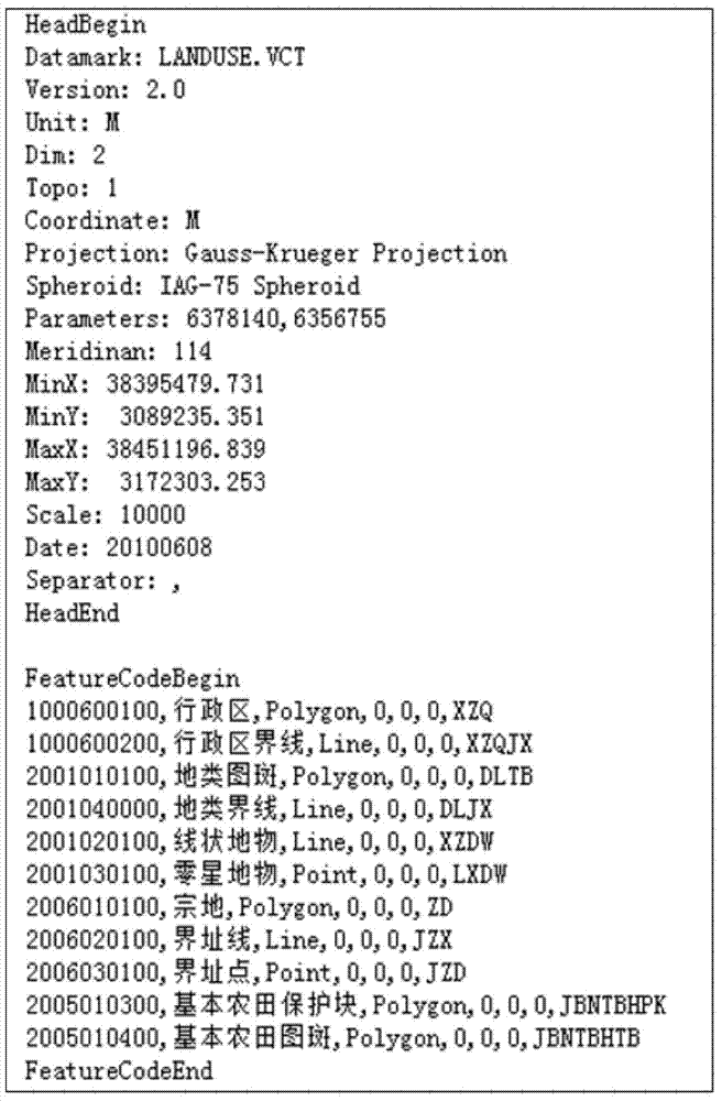
[0048] The input data of this embodiment is a VCT file output from a certain land use database, and the data volume is 450 MB. Part of the information of the VCT file is as follows Figure 3a As shown, the map projection is Gauss-Krüger projection, and the reference ellipsoid is IAG-75 ellipsoid. The file contains three types of geometric projection data: point, line, and surface, including 11 layers of administrative regions, administrative region boundaries, land-type maps, land-type boundaries, and sporadic features.

[0049] The test environment used in this example is: IBM System x3500-M3X server, configured as 2 Intel...


PUM


Abstract

The invention relates to a vector data concurrent conversion method from a VCT file to a shapefile file. The method comprises the steps of respectively establishing a file header, element type parameters, an attribute data structure, annotations, geometric figure data and element indexes of attribute data in the VCT file at first, conducting statistics on geometric figure data types of each layer and the included geometric figure data bulk, sorting the layers with the same geometric figure data type according to the included geometric figure data bulk, then accumulating point data of the layers to obtain total point data w, dividing the VCT file into p vector target subsets according to the course number p, conducting matching on the coordinate information, attribute data and the layers of corresponding elements of the geometric figure data analyzed from the VCT file through the p courses at last, and respectively storing the data of the layers into the independent shapefile file. According to the vector data concurrent conversion method, fast conversion of the vector geographic data VCT file can be achieved through concurrent processing.

Description

technical field [0001] The invention relates to a vector data parallel conversion method from a VCT file to a shapefile file, and belongs to the technical field of geographic information processing. Background technique [0002] Geographic Information System (GIS) is a comprehensive technology of computer science, geography, surveying, cartography and other disciplines, and vector data structure is an important data structure form in GIS. The vector data structure model adopted by the geographic information system abstracts spatial geological entities into three geometric elements: point, line, and surface. The vector data structure expresses the correlation of spatial entities by optimizing the topology structure, and establishes a framework for the spatial database. [0003] With the rapid development of the GIS industry, geographic data has become an important data resource in many departments and industries. Ensuring smooth exchange and eliminating information islands ar...

Claims


Application Information

Patent Timeline
Patent Type & Authority Applications(China)
IPC IPC(8): G06F17/30
CPCG06F16/116G06F16/29
Inventor 陈振杰周琛李飞雪黄秋昊陈冲吴洁璇黄涛
Owner NANJING UNIV
Why Eureka
Try Eureka