Hyperspectral remote sensing image dimensionality reduction method based on conformal geometric algebra
A technology of hyperspectral remote sensing and geometric algebra, which is applied in the field of hyperspectral remote sensing image dimensionality reduction based on conformal geometric algebra, can solve the problems of large information loss and poor effect of hyperspectral remote sensing bands
- Summary
- Abstract
- Description
- Claims
- Application Information
AI Technical Summary
Problems solved by technology
Method used
Image
Examples
Embodiment
[0039] Example: The experimental data is a hyperspectral image of Washington DC acquired by a HYDICE (Hyperspectral Digital Imagery Collection Experiment) sensor. The data covered 210 bands in the spectral range from 0.4 to 2.5um, and its spatial resolution was about 2.8m; after removing water absorption bands and noise bands, 191 bands were reserved for data analysis. The experimental data is a sub-image cut from the original image of DC Mall, where the data size is 304×301, including buildings (Roof), trees (Tree), grassland (Grass), water bodies (Water), roads (Road), and 7 categories including trails.
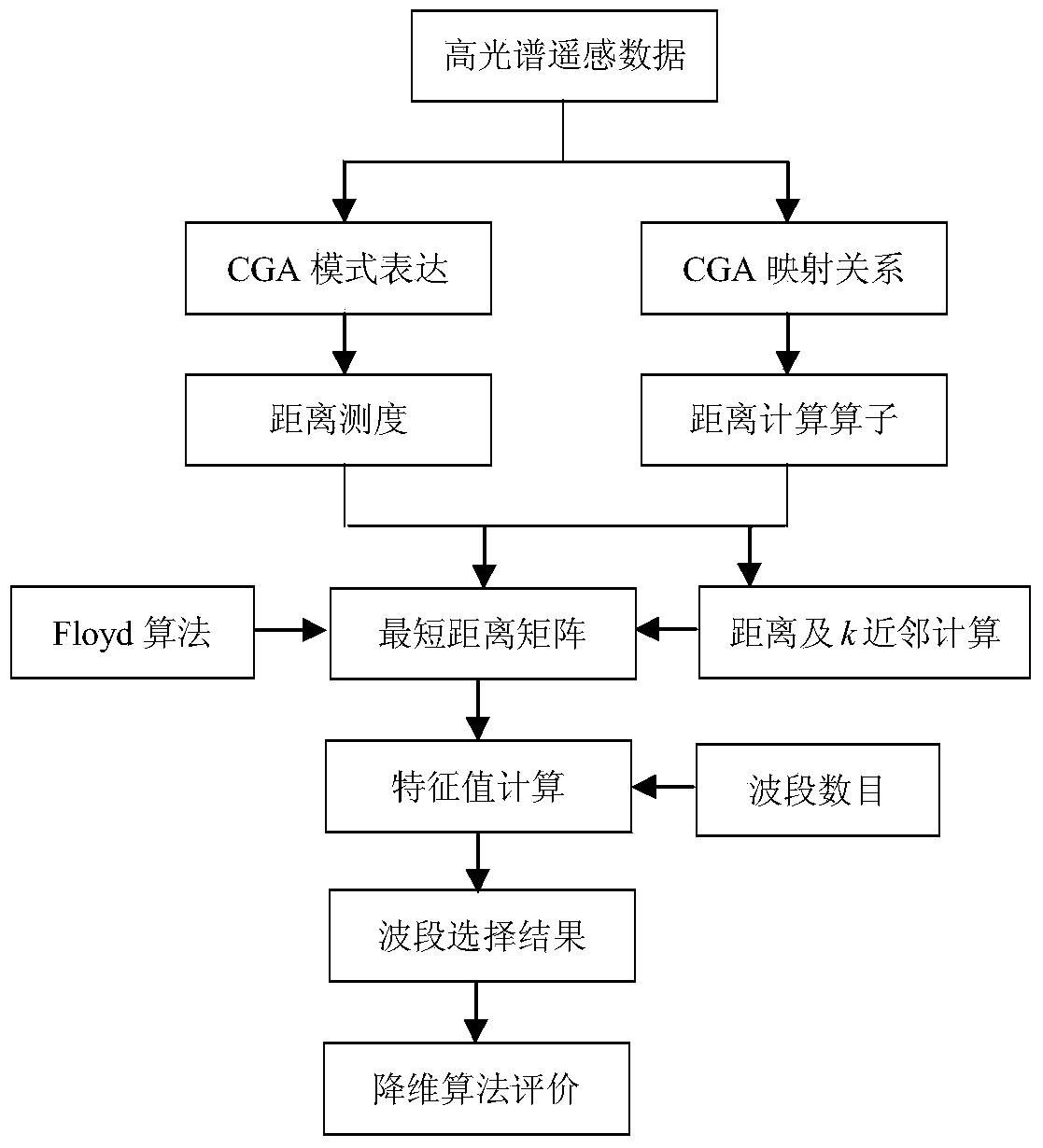
[0040] like figure 1 As shown, the specific implementation steps are:
[0041] (1) Determine the hyperspectral remote sensing image data to be processed, perform data preprocessing on it, remove noise bands, and reserve 191 bands for data analysis, then determine typical spectral data and training sample data, and specify the bands to be selected in advance the number is...
PUM
 Abstract
Description
Claims
Application Information
 - R&D
- Intellectual Property
- Life Sciences
- Materials
- Tech Scout
- Unparalleled Data Quality
- Higher Quality Content
- 60% Fewer Hallucinations
Browse by: Latest US Patents, China's latest patents, Technical Efficacy Thesaurus, Application Domain, Technology Topic, Popular Technical Reports.
© 2025 PatSnap. All rights reserved.Legal|Privacy policy|Modern Slavery Act Transparency Statement|Sitemap|About US| Contact US: help@patsnap.com


