
A sea cliff erosion scale measuring device and its measuring method

A technology of measuring devices and measuring methods, which is applied in measuring devices, surveying and navigation, open-air water source surveying, etc., can solve problems such as difficult to measure, and achieve the effects of easy implementation, simple and accurate measuring methods, and simple structure

Active Publication Date: 2016-02-24
HUAQIAO UNIVERSITY
View PDF4 Cites 2 Cited by
  • Summary
  • Abstract
  • Description
  • Claims
  • Application Information

AI Technical Summary

Problems solved by technology

[0003] At present, methods such as comparison of coastal remote sensing data over the years and fixed-point piles are commonly used to measure the erosion of coastal zones. These measurement methods are usually suitable for the erosion measurement of coastlines. For the erosion scale of a two-dimensional section with a certain height of sea cliffs, it is difficult Measurement

Method used


Image

  • A sea cliff erosion scale measuring device and its measuring method

Examples


Embodiment Construction

[0026] The present case will be described in further detail below in conjunction with the accompanying drawings and specific embodiments.

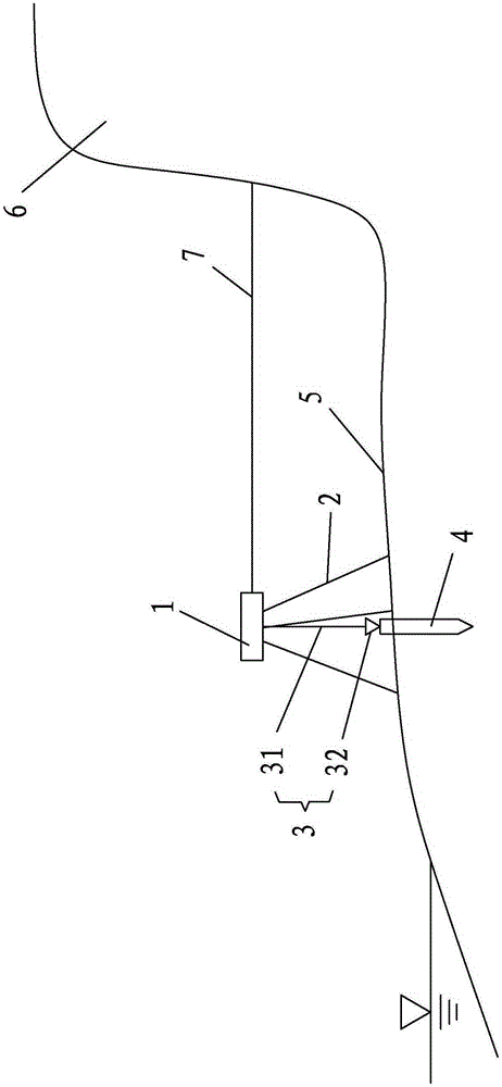
[0027] The invention relates to a sea cliff erosion scale measuring device, such as figure 1 As shown, it is mainly composed of a range finder 1, a tripod 2, a hanging hammer 3 and a wooden pile 4. Among them, in the measurement state:

[0028] Wooden stake 4 drives in the beach surface 5 in front of the measured sea cliff 6, and tripod 2 is set up on the beach surface 5 and above the corresponding wooden stake 4, and tripod 2 can adopt the tripod used when taking pictures in common.

[0029] The range finder 1 is installed on the tripod 2, and the range finder 1 can be used for movable rotation and positioning along the horizontal and vertical directions; the range finder 1 adopts a laser range finder capable of measuring inclination, and measures the Can reach 50-100m;

[0030] The hanging hammer 3 is made up of a rope 31 and a bottom...


PUM


Abstract

The invention discloses a sea cliff erosion scale measuring device and method. The device comprises a distance measurer, a tripod, a drop hanger and a wood pile, wherein the tripod is erected on a beach face in front of a measured sea cliff; the drop hammer is composed of a rope and a base cone; the base cone is suspended on the top of the tripod by the rope; the wood pile is punched in the beach face in the front of the sea cliff and oppositely contacts with the base cone in an up-down manner; the distance measurer can be a laser distance measurer for measuring a tilt angle; the laser distance measurer can arranged on the tripod in a movable rotating and positioning manner along the horizontal direction and the vertical direction. During measuring, the wood pile is used for positioning and the distance measurer is used for measuring distances at different tilt angles, so that a two-dimensional section shape of the face of the cliff can be drawn out, and therefore, the shape of the face of the cliff is respectively measured at different moments, and the sea cliff erosion scale can be obtained by comparing the shapes at the different moments. Obtained two-dimensional section data of the sea cliff erosion provides base data for predicating and preventing of geological disasters in a coastal zone as well as urban and rural land planning in the costal zone.

Description

technical field [0001] The invention relates to the field of disaster prevention and reduction in coastal zones, in particular to a measuring device and a measuring method for measuring the erosion scale of sea cliffs. Background technique [0002] Sea cliffs are platform-like landform accumulations located in the coastal zone with a certain height and a large slope, and are a common landform in the coastal zone. As waves and winds erode and cut the cliff foot, most of the sea cliffs, especially the soft sea cliffs, gradually retreat towards the land, causing damage to the engineering facilities on the top of the sea cliffs. Therefore, measuring and comparing the cross-sectional shapes of sea cliffs at different times can obtain the erosion scale of sea cliffs and further predict the future erosion of sea cliffs, which is of great significance for the prediction and prevention of coastal geological disasters and urban and rural land planning in coastal zones. [0003] At pr...

Claims


Application Information

Patent Timeline
Patent Type & Authority Patents(China)
IPC IPC(8): G01C7/02G01C13/00
CPCG01C7/02
Inventor 常方强
Owner HUAQIAO UNIVERSITY
Learn More