
Method for determining optimal path of flight vehicle based on self-adaptive A star algorithm

A technology of optimal path and determination method, which is applied in the direction of navigation calculation tools, etc., can solve the problems of inability to adapt to dynamics, reduce the degree of dependence, and fail to calculate the overall path, so as to overcome the lack of robustness, shorten the length of the path, and reduce the number of waypoints. Reduced effect

Inactive Publication Date: 2014-04-02
XIDIAN UNIV
View PDF5 Cites 20 Cited by
  • Summary
  • Abstract
  • Description
  • Claims
  • Application Information

AI Technical Summary

Problems solved by technology

Compared with the traditional algorithm, the robustness has been significantly improved, and the dependence on the idealization of obstacle objects has been reduced. However, the calculation time of the intelligent optimization algorithm is generally too long to adapt to the dynamic and variable map that is closer to the real scene. route plan
For other algorithms, such as the dynamic programming algorithm, due to the limitations of the algorithm itself, it can achieve the optimal and adapt to the dynamic map on the local path, but it cannot be guaranteed on the global planning, and the path result may be unstable and the overall path cannot be calculated.

Method used


Image

  • Method for determining optimal path of flight vehicle based on self-adaptive A star algorithm
  • Method for determining optimal path of flight vehicle based on self-adaptive A star algorithm
  • Method for determining optimal path of flight vehicle based on self-adaptive A star algorithm

Examples


Embodiment Construction

[0033] The steps of the present invention will be further described in detail below in conjunction with the accompanying drawings.

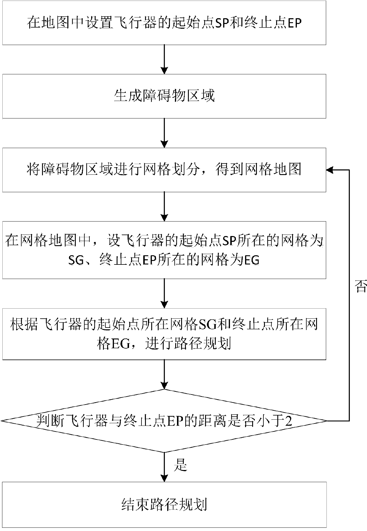
[0034] refer to figure 1 , the implementation steps of the present invention are as follows:

[0035] Step 1. Set the start point and end point of the aircraft, that is, mark the start point SP and end point EP of the aircraft on the map.

[0036] Step 2. Generate obstacle areas.

[0037] 2a) Establish a Cartesian coordinate system according to the positions of the starting point SP and the ending point EP of the aircraft;

[0038] 2b) Let p i ,q i Respectively, the coordinates of the starting point and the ending point of each obstacle that the aircraft needs to bypass, for p i Points are respectively made a straight line perpendicular to the X-axis and Y-axis of the Cartesian coordinate system, for q iThe points are respectively drawn as straight lines perpendicular to the X-axis and Y-axis of the Cartesian coordinate system, and a rectan...


PUM


Abstract

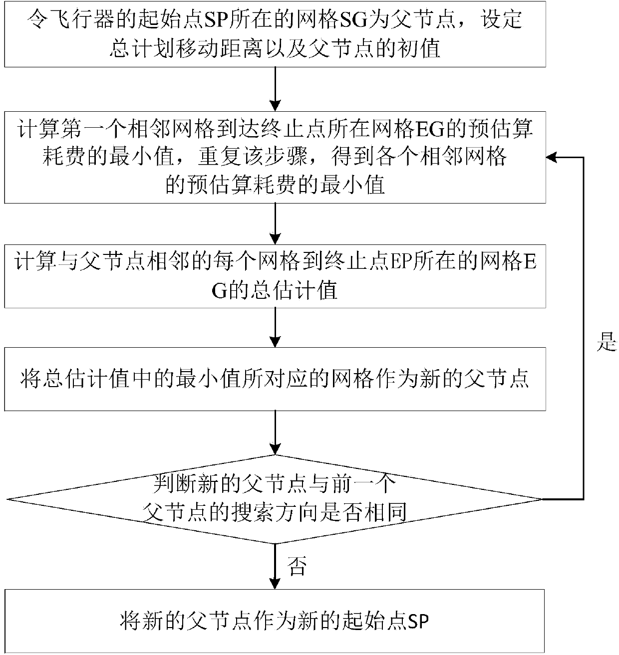
The invention discloses a method for determining an optimal path of a flight vehicle based on a self-adaptive A star algorithm, which is mainly used for solving the problems of excessively long length of the divided path, excessively large threat value of an obstacle to the flight vehicle and excessively large number of waypoints of the prior art. The method comprises the following implementation steps: (1) setting a start point SP and an end point EP of the flight vehicle in a map; (2) generating an obstacle region; (3) performing grid division on the obstacle region to obtain a grid map; (4) setting a grid where the start point SP of the flight vehicle is located as SG and setting the grid where the end point EP is located as EG in the grid map; (5) performing path planning according to the grid SG where the start point of the flight vehicle is located and the grid EG where the end point is located. The method disclosed by the invention has the advantages of short path length, low threat value and a small number of waypoints, and can be used for determining the optimal path of the flight vehicle.

Description

technical field [0001] The invention belongs to the technical field of spatial data processing, and in particular relates to path planning of an aircraft. The method can be used for path planning in fields such as intelligent navigation and unmanned driving. Background technique [0002] The aircraft relies on terrain information and enemy information for path planning, that is, under certain constraints, the aircraft searches for the optimal flight path that can preferentially satisfy a specific purpose from the starting point to the ending point, where the flight path is represented by a series of waypoints. [0003] With the continuous development of military technology and actual war requirements, the path planning modeling of aircraft has developed from a single system to a complex and changeable system. The path planning problem of aircraft presents complex characteristics such as real-time, multi-dimensionality, uncertainty and nonlinearity. The models established un...

Claims


Application Information

Patent Timeline
IPC IPC(8): G01C21/20
CPCG01C21/20
Inventor 于昕焦李成朱振强马晶晶马文萍刘军强李阳阳
Owner XIDIAN UNIV
Learn More