
Forest burned area automatic extraction method based on time sequence remote sensing image

A technology of remote sensing images of burnt areas, applied in the field of forest fire monitoring

Inactive Publication Date: 2014-04-02
INST OF REMOTE SENSING & DIGITAL EARTH CHINESE ACADEMY OF SCI
View PDF6 Cites 20 Cited by
  • Summary
  • Abstract
  • Description
  • Claims
  • Application Information

AI Technical Summary

Problems solved by technology

[0004] The purpose of the present invention is to provide a method for automatically extracting forest fire traces using multi-temporal remote sensing images, so as to overcome the shortcomings of the existing methods
Utilizing the present invention can realize the fast and accurate extraction of forest fire burnt areas using remote sensing images, thereby solving the aforementioned problems existing in existing methods, and improving the application level of remote sensing images in the field of forest fire monitoring

Method used


Image

  • Forest burned area automatic extraction method based on time sequence remote sensing image
  • Forest burned area automatic extraction method based on time sequence remote sensing image
  • Forest burned area automatic extraction method based on time sequence remote sensing image

Examples


Embodiment Construction

[0018] In order to make the object, technical solution and advantages of the present invention clearer, the present invention will be further described in detail below in conjunction with the accompanying drawings. It should be understood that the specific embodiments described here are only used to explain the present invention, and are not intended to limit the present invention.

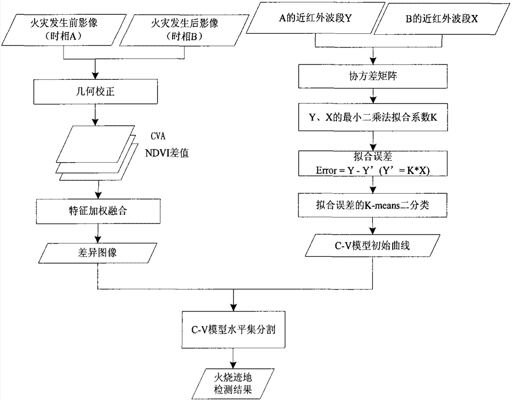
[0019] Such as figure 1 The present invention discloses a method for automatically extracting forest fire traces based on time-series remote sensing images, comprising the following steps:

[0020] The first step is to obtain the difference image;

[0021] The second step is the initial curve setting of the C-V model;

[0022] The third step is to extract the burn marks.

[0023] The specific steps are described in detail below:

[0024] Difference image acquisition is the first step in the automatic extraction of forest burnt areas using change detection methods. The purpose is to obtain the ...


PUM


Abstract

The invention discloses a forest burned area automatic extraction method based on a time sequence remote sensing image. The method comprises the following three steps: 1, selecting cloudless remote sensing images before and after occurrence of a forest fire, calculating variable quantity of each band and a vegetation index difference image of two time phase remote sensing images, and carrying out weighted fusion on the variable quantity of each band and the vegetation index difference image to obtain a difference image; 2, carrying out linear fitting on near infrared bands before and after the occurrence of the fire to obtain a fitting error image, then carrying out binarization classification on the fitting error image, and setting a classification result as an initial curve of a C-V (Chan-Vese) model; 3, inputting the obtained difference image and the initial curve as the C-V model, and carrying out segmentation on the difference image obtained in the step 1 by using the C-V model to realize the automatic extraction of burned area information. By adopting the extraction method disclosed by the invention, a burned area can be fast and automatically extracted by using the remote sensing images, and the method is strong in operability, clear in extracted burned area contour, high in detection precision, and strong in practicability, and further can be used for extracting forested region burned areas in a variety of land satellite image data.

Description

technical field [0001] The invention relates to a method for automatically extracting forest fire traces by using time-series remote sensing images, which is suitable for the field of forest fire monitoring. Background technique [0002] Forest fire is the most destructive natural disaster to forests. It not only destroys the ecological structure of forests, but also has an important impact on human living environment. The detection of the location and coverage of the burned area can not only effectively obtain the burned area of ​​the forest, so as to evaluate the fire loss, but also help the forestry department to effectively carry out the vegetation restoration work after the fire. Remote sensing data acquisition has the advantages of wide field of view, multi-band, multi-temporal and fast, and provides an effective technical means for the detection of forest fires. At present, the commonly used methods for extracting forest burnt areas using remote sensing data include ...

Claims


Application Information

Patent Timeline
IPC IPC(8): G06T7/00
Inventor 戴芹杨进刘洋刘建波刘士彬
Owner INST OF REMOTE SENSING & DIGITAL EARTH CHINESE ACADEMY OF SCI
Learn More