BDS (Beidou Navigation System) and GIS (Geographic Information System) deep coupling location method and system based on UKF (Unscented Kalman Filter)

A positioning method and deep coupling technology, applied in the field of satellite positioning, can solve the problems of increased positioning error, poor stability, short life, etc., and achieve the effect of avoiding linearization and excellent accuracy and stability

Active Publication Date: 2014-04-16
苍穹数码技术股份有限公司 +1
View PDF5 Cites 8 Cited by
  • Summary
  • Abstract
  • Description
  • Claims
  • Application Information

AI Technical Summary

Problems solved by technology

[0005] (1) When the satellite signal is weak for a long time, INS can only guarantee the navigation accuracy for a short period of time, and the INS positioning error will increase with time, and the navigation result will not be guaranteed, which cannot meet the high-precision positioning requirements
[0006] (2) The filtering algorithm currently uses EKF (Extended Kalman Filter) filtering, which is to truncate the Taylor expansion of the nonlinear function to the first-order linearization and ignore other high-order terms, so as to transform the nonlinear problem into a linear one. When linear, EKF violates the local linear assumption, and when the neglected high-order terms in the Taylor expansion bring large errors, the EKF algorithm may cause the filter to diverge, resulting in low estimation accuracy and poor stability.
Platform-type inertial navigation installs the inertial measurement device on an inertial platform, which has a complex structure, large volume and weight, and short life
Strapdown inertial navigation is to install the inertial measurement device directly on the carrier, and use the digital calculation of the computer to replace the analog tracking function of the platform. However, because there is no inertial platform, the dynamic impact of the carrier directly acts on the inertial components, so the working environment is harsh. Strapdown inertial navigation is difficult to achieve the highest accuracy that platform inertial navigation can achieve

Method used


Image

  • BDS (Beidou Navigation System) and GIS (Geographic Information System) deep coupling location method and system based on UKF (Unscented Kalman Filter)
  • BDS (Beidou Navigation System) and GIS (Geographic Information System) deep coupling location method and system based on UKF (Unscented Kalman Filter)
  • BDS (Beidou Navigation System) and GIS (Geographic Information System) deep coupling location method and system based on UKF (Unscented Kalman Filter)

Examples


Embodiment Construction

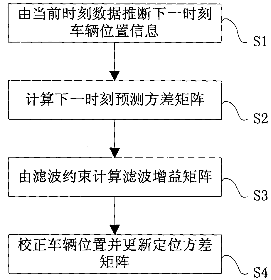
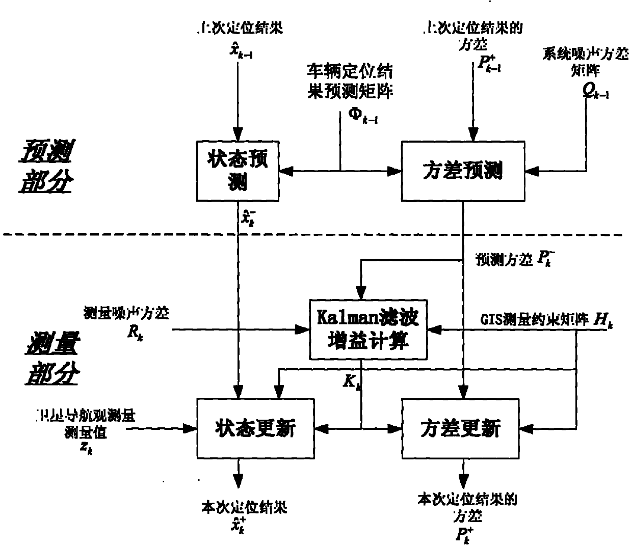
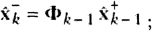
[0037] The following will clearly and completely describe the technical solutions in the embodiments of the present invention with reference to the drawings in the embodiments of the present invention. Apparently, the described embodiments are preferred implementation modes for implementing the present invention, and the description is for the purpose of illustrating the general principle of the present invention, and is not intended to limit the scope of the present invention. The scope of protection of the present invention should be defined by the claims. Based on the embodiments of the present invention, all other embodiments obtained by those of ordinary skill in the art without creative efforts belong to the protection of the present invention. range.

[0038] The traditional satellite navigation and INS combined positioning technology can provide navigation and positioning with a certain accuracy when the number of effective satellites is less than 4 in a short period o...


PUM


Abstract

The invention relates to the technical field of satellite location and discloses a BDS (Beidou Navigation System) and GIS (Geographic Information System) deep coupling location method and system based on a UKF (Unscented Kalman Filter). The BDS (Beidou Navigation System) and GIS (Geographic Information System) deep coupling location method comprises the steps: establishing a forecasting matrix of vehicle location, and deducing vehicle position information at a next moment according to vehicle position information at a current moment after corrected and the forecasting matrix; calculating a forecasting variance matrix at the next moment according to a location variance matrix at the current moment; organizing a GIS road model, and calculating a filter gaining matrix according to the road model, measurement noises and the forecasting variance matrix at the next moment; and acquiring a navigation location observed quantity at the next moment, outputting and correcting the observed quantity according to the filter gaining matrix to form a vehicle position at the next moment after correcting, and updating the location variance matrix at the next moment. According to the BDS (Beidou Navigation System) and GIS (Geographic Information System) deep coupling location method and system disclosed by the invention, a geographic information system technology is adopted, the amendment of a location error originates from the accurate GIS model, and the technical problem that the location error is increased along with the time lapse is solved.

Description

technical field [0001] The invention relates to the technical field of satellite positioning, in particular to a BDS and GIS deep coupling positioning method and system based on UKF filtering. Background technique [0002] Satellite navigation and positioning technology uses satellites for all-weather, continuous, real-time three-dimensional navigation and positioning and speed measurement, and can also perform high-precision time transfer and high-precision precise positioning. At present, satellite positioning systems include GPS (Global Positioning System) of the United States, GLONASS (Global Navigation Satellite System) of Russia, GALILEO (Galileo Project) of the European Union, and BDS (Beidou Navigation System) of China. Satellite navigation and positioning technology requires at least 4 satellites to maintain visibility before positioning, because the high dynamic environment will weaken the ability of satellite receivers to capture and track satellite signals, and e...

Claims


Application Information

Patent Timeline
Patent Type & Authority Applications(China)
IPC IPC(8): G01C21/26
CPCG01C21/165G01C21/20G01S19/49
Inventor 谭吉福杨必武杨春朱江蒲鹏程苏望发刘旭王宁
Owner 苍穹数码技术股份有限公司
Why Eureka
Try Eureka