Network map intelligent generation method and system based on remote sensing image

A network map and remote sensing image technology, applied in the field of computer vision, can solve the problems of distortion of generated map elements, inconsistent global style, blurred local details, etc., and achieve the effect of reducing interference.

Active Publication Date: 2021-06-11
BEIJING INSTITUTE OF TECHNOLOGYGY
View PDF8 Cites 1 Cited by
  • Summary
  • Abstract
  • Description
  • Claims
  • Application Information

AI Technical Summary

Problems solved by technology

[0011] However, the direct use of native methods has many problems such as distortion of generated map elements, inconsistent global style, and blurred local details.

Method used


Image

  • Network map intelligent generation method and system based on remote sensing image
  • Network map intelligent generation method and system based on remote sensing image
  • Network map intelligent generation method and system based on remote sensing image

Examples


Embodiment

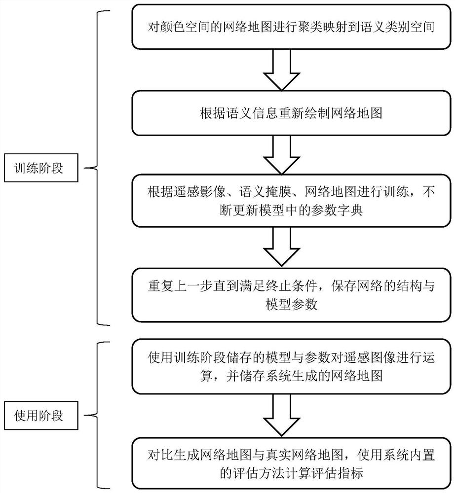
[0099] This embodiment discloses a method for intelligently generating a network map based on remote sensing images, including a training phase and a use phase.

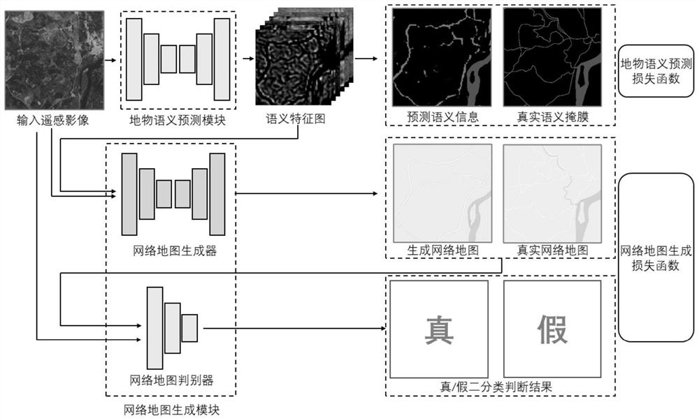
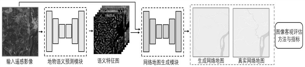
[0100] In the training phase, in the training data set of remote sensing image-network map pairing, the network map in the RGB color space is clustered by pixel three-color values, and the mapping mask of the network map in the feature category space is obtained; according to the network The mapping mask of the map in the feature category space redraws the network map, so that the color values ​​​​in the network map are unified and standardized, and the information disturbance caused by the network map drawing process is reduced; the intelligent generation algorithm model generates a copy based on the input remote sensing image The prediction result of the feature category mask and a generated network map, and compare it with the real feature category mask and the real network map, calculate its loss function and upda...


PUM


Abstract

The invention relates to a network map intelligent generation method and system based on a remote sensing image, and belongs to the technical field of computer vision. According to the method, the semantic category of the collected network map is extracted and redrawn, so that correctness of semantics contained in the network map can be explicitly corrected in the model training process, and color value unification and standardization in the network map are realized. A dual-module design of a ground feature semantic information prediction module and a network map generation module is used, and each module can be updated according to a current latest or future updated semantic segmentation technology and an image generation technology, so that ground feature semantic information of a remote sensing image can be understood and corrected explicitly; and information such as image styles, drawing specifications, detail features and the like contained in the network map can be learned in a self-adaptive manner by means of adversarial generation. According to the method, on the premise that special equipment is not needed and the generation speed is high, the accuracy degree and the sensory quality of map generation under the complex real remote sensing image are improved.

Description

technical field [0001] The invention relates to a method and system for intelligently generating a network map, in particular to a method and system for intelligently generating a network map based on remote sensing images, and belongs to the technical field of computer vision. Background technique [0002] Remote sensing technology refers to the technology of collecting electromagnetic radiation information of ground objects and targets from artificial satellites, airplanes, unmanned aerial vehicles or other aircraft to determine relevant information such as surface environment and resources. In recent years, with the continuous optimization of artificial earth satellite launch technology, the number and quality of artificial satellites available to humans have been rapidly improved, which has greatly promoted the development of remote sensing technology. [0003] The technology of detecting and identifying targets by sensing electromagnetic waves reflected or radiated by t...

Claims


Application Information

Patent Timeline
Patent Type & Authority Applications(China)
IPC IPC(8): G06T17/05G06T17/20G06K9/46G06K9/62G06N3/04
CPCG06T17/05G06T17/205G06V10/56G06N3/045G06F18/23213
Inventor 付莹梁帅哲
Owner BEIJING INSTITUTE OF TECHNOLOGYGY
Why Eureka
Try Eureka