Forest resource measuring method based on satellite remote sensing technology

A technology for forest resources and satellite remote sensing, which is applied in the field of forest resources measurement based on satellite remote sensing technology, can solve the problems of difficult implementation, low measurement accuracy, and small coverage, and achieves large coverage, high measurement accuracy, and low implementation difficulty. Effect

Inactive Publication Date: 2014-04-23
GUANGXI ECO ENG VOCATIONAL & TECHN COLLEGE +2
View PDF6 Cites 14 Cited by
  • Summary
  • Abstract
  • Description
  • Claims
  • Application Information

AI Technical Summary

Problems solved by technology

[0005] In the process of realizing the present invention, the inventor found that there are at least some defects in the prior art, such as low measurement accuracy, small coverage area and high implementation difficulty

Method used


Image

  • Forest resource measuring method based on satellite remote sensing technology
  • Forest resource measuring method based on satellite remote sensing technology
  • Forest resource measuring method based on satellite remote sensing technology

Examples


Embodiment Construction

[0047] The preferred embodiments of the present invention will be described below in conjunction with the accompanying drawings. It should be understood that the preferred embodiments described here are only used to illustrate and explain the present invention, and are not intended to limit the present invention.

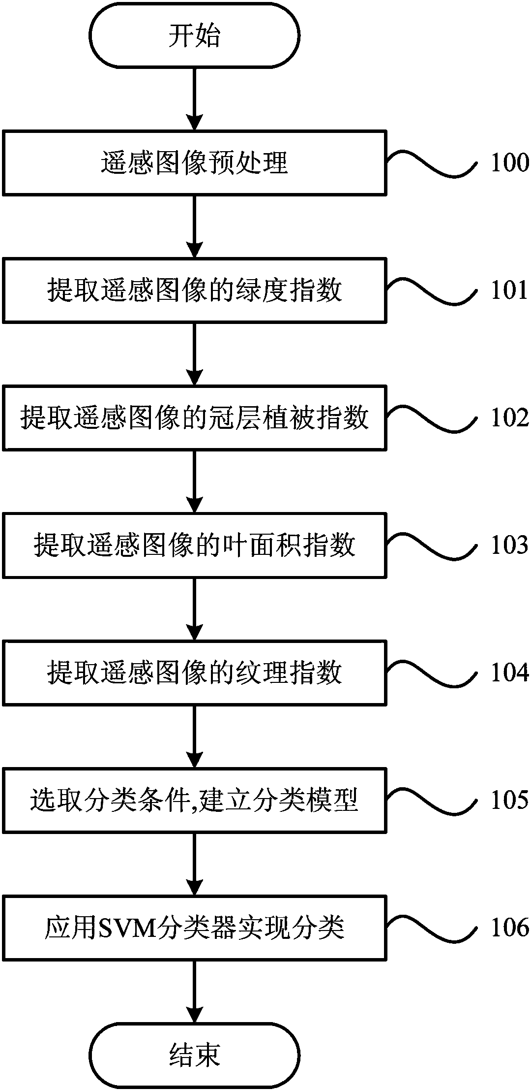
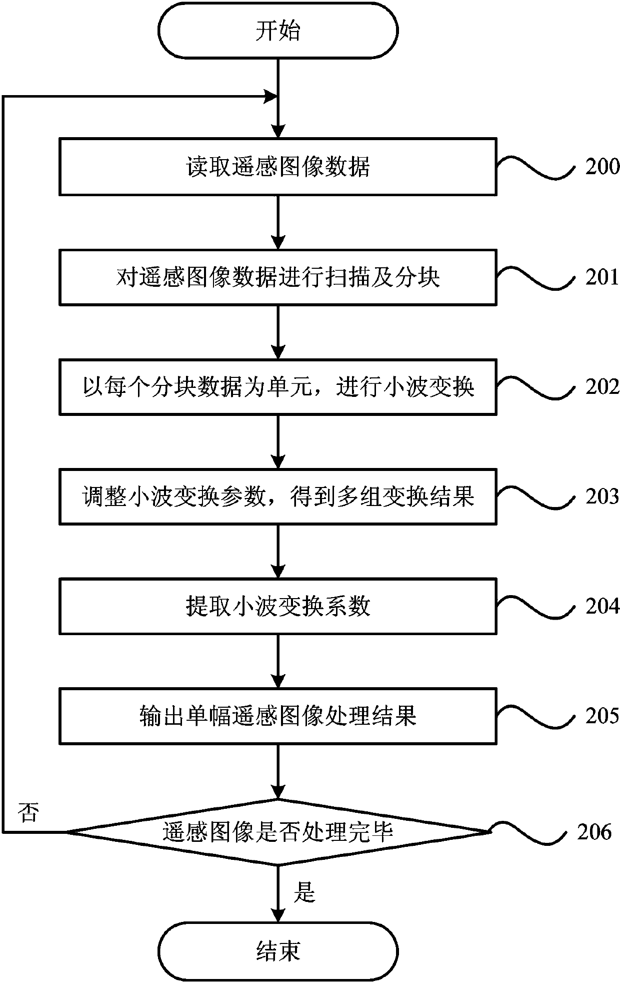
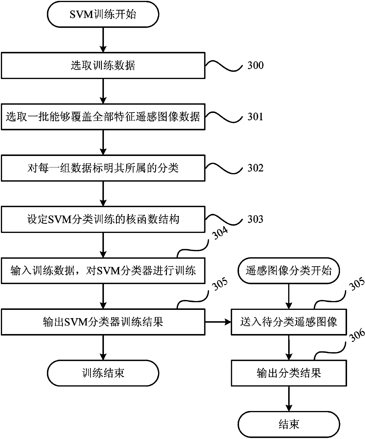
[0048] According to an embodiment of the present invention, such as figure 1 , figure 2 and image 3 As shown, a forest resource measurement method based on satellite remote sensing technology is provided, that is, a method for analyzing and processing forest resource images using satellite remote sensing technology, which can meet the needs of large-scale use of satellite remote sensing technology to achieve forest resource coverage, forest Resource accumulation, types, health status and other information are calculated with high precision, which has the characteristics of fast calculation speed, wide coverage and high precision. The forest resource measurement ...


PUM


Abstract

The invention discloses a forest resource measuring method based on a satellite remote sensing technology. The method comprises that: remote sensing image information based on a forest resource to be measured is acquired via the satellite remote sensing technology, and the acquired remote sensing image information is preprocessed; a main parameter index of the forest resource to be measured is extracted on the basis of the preprocessing result of the remote sensing image information; multiple forest resource index numerical values in a remote sensing image are counted on the basis of the extracted main parameter index; a classification condition is selected according to the counting result, and a classification model supporting a vector machine is established; and the forest resource to be measured is classified by using an SVM classifier on the basis of the established the classification model supporting the vector machine. According to the forest resource measuring method based on the satellite remote sensing technology, defects in the prior art that measuring accuracy is low, coverage range is small and enforcement difficulty is high, etc. can be overcome so that advantages of being high in measuring accuracy, large in coverage range and low in enforcement difficulty can be realized.

Description

technical field [0001] The invention relates to the technical field of image processing, in particular to a method for measuring forest resources based on satellite remote sensing technology. Background technique [0002] The modernization of forest resource management has prompted people to put forward higher requirements for the precision and fineness of forest resource management. Obtaining forest resource information by means of traditional actual sampling survey has low precision, and the sampling coverage and sampling quantity are very limited, which makes it difficult for the traditional forest resource assessment technology based on the extraction calculation method to meet the needs of modern forest resources. management needs. [0003] The use of remote sensing satellites to achieve accurate measurement of forest resources is a very promising forest resource management method at present. The use of satellite remote sensing technology can conduct comprehensive ana...

Claims


Application Information

Patent Timeline
IPC IPC(8): G06K9/66
Inventor 黄寿昌刘有莲潘大庆蔡朝容黄力
Owner GUANGXI ECO ENG VOCATIONAL & TECHN COLLEGE
Why Eureka
Try Eureka