Real-time and accurate pose estimation method based on fiber-optic gyroscope, speed sensor and GPS

A speed sensor and fiber optic gyroscope technology, which is used in instruments, satellite radio beacon positioning systems, measuring devices, etc., to achieve the effects of small environmental impact, elimination of random noise, and correction of accumulated errors

Inactive Publication Date: 2014-05-07
XI AN JIAOTONG UNIV
View PDF7 Cites 30 Cited by
  • Summary
  • Abstract
  • Description
  • Claims
  • Application Information

AI Technical Summary

Problems solved by technology

[0009] The purpose of the present invention is to overcome the shortcoming of existing GPS positioning method, provide a kind of real-time accurate pose estimation method based on fiber optic gyroscope, velocity sensor and GPS

Method used


Image

  • Real-time and accurate pose estimation method based on fiber-optic gyroscope, speed sensor and GPS
  • Real-time and accurate pose estimation method based on fiber-optic gyroscope, speed sensor and GPS
  • Real-time and accurate pose estimation method based on fiber-optic gyroscope, speed sensor and GPS

Examples


Embodiment Construction

[0043] The present invention will be further described below in conjunction with accompanying drawing.

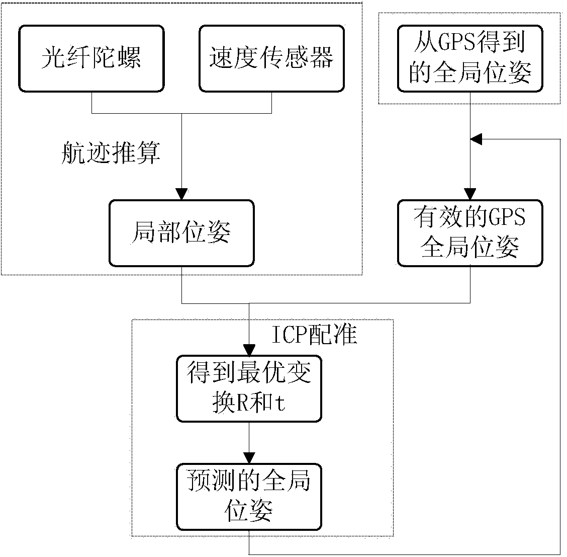
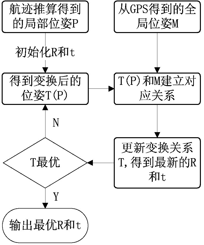
[0044] see figure 1 , the real-time accurate pose estimation method based on fiber optic gyroscope, speed sensor and GPS is divided into three parts, including the following steps:

[0045] 1) The local pose is obtained by the fiber optic gyroscope and the speed sensor. The specific steps are as follows:

[0046] (1a) Gyro output heading angle θ information;

[0047] (1b) Parse the real-time front wheel speed and front wheel angle from the UDP (User Data Protocol) packet to obtain the speed information;

[0048] (1c) Calculate the relative displacement according to the velocity information of the two frames before and after;

[0049] (1d) Real-time dead reckoning to obtain local position information;

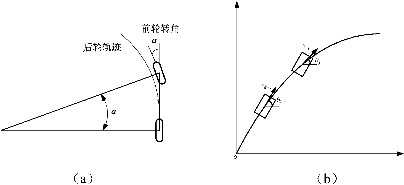
[0050] according to figure 2 (a), the real-time rear wheel speed (speed in the direction of vehicle movement) can be obtained: the speed sensor reads the speed informat...


PUM


Abstract

The invention provides a real-time and accurate pose estimation method based on a fiber-optic gyroscope, a speed sensor and a GPS. The unmanned vehicle local locating algorithm based on a vehicle body motion model is mainly based on the two-dimensional plane dead reckoning principle, the vehicle body current local pose is estimated through the vehicle body sensor speed and course information estimation at the previous time, and the gyroscope course accumulative error is compensated through a linear model, so the accuracy of the local locating system can be improved; and by using the iterative closet point algorithm to register GPS and the local pose measuring system pose estimation method, the local locating accumulative error can be corrected, so the random noise of the GPS can be effectively eliminated, and the pose accuracy can be maintained when the GPS is in complete failure condition or failed, and the running test result shows that the method provided in the invention can be used to well fuse multi-sensor information, and provide reliable and continuous locating information for unmanned vehicles in multi-tree and multi-building urban environments. Moreover, the method has the advantage of good real-time performance.

Description

technical field [0001] The invention relates to the fields of mobile robots, navigation and positioning, and data fusion, and in particular to a method of calculating local attitude information of unmanned vehicles by using sensors such as fiber optic gyroscopes and odometers of smart vehicles, using GPS to obtain global poses, and calculating local poses of unmanned vehicles. A method to obtain a revised global pose by registering with the GPS position. Background technique [0002] With the continuous development of science and technology, unmanned vehicles (unmanned vehicles) have more and more applications in the mining industry, cargo transportation, agricultural automation and military fields. The navigation and positioning system provides real-time position and attitude information for unmanned vehicles to ensure that unmanned vehicles complete autonomous navigation and precise control according to the correct route, which is an important part of the unmanned vehicle ...

Claims


Application Information

Patent Timeline
Patent Type & Authority Applications(China)
IPC IPC(8): G01S19/53G01C21/00
CPCG01C21/165G01S19/47
Inventor 杜少毅宋晔刘娟薛建儒张春家祝继华
Owner XI AN JIAOTONG UNIV
Why Eureka
Try Eureka