Indoor-flying intelligent body inertial system and laser range finder combination type navigation improving method

A laser range finder and integrated navigation technology, which is applied in surveying and navigation, navigation through speed/acceleration measurement, navigation, etc., can solve the problem of divergent track of the navigation system, achieve the purpose of suppressing divergence, improving the accuracy of state estimation, and strong The effect of practicality

Inactive Publication Date: 2014-05-21
南京恒誉名翔科技有限公司
View PDF0 Cites 22 Cited by
  • Summary
  • Abstract
  • Description
  • Claims
  • Application Information

AI Technical Summary

Problems solved by technology

This improved method can effectively solve the divergence problem of the indoor flight intelligent body integrated navigation system ...

Method used


Image

  • Indoor-flying intelligent body inertial system and laser range finder combination type navigation improving method
  • Indoor-flying intelligent body inertial system and laser range finder combination type navigation improving method
  • Indoor-flying intelligent body inertial system and laser range finder combination type navigation improving method

Examples


Embodiment Construction

[0040] Below in conjunction with accompanying drawing, technical scheme of the present invention is described in detail:

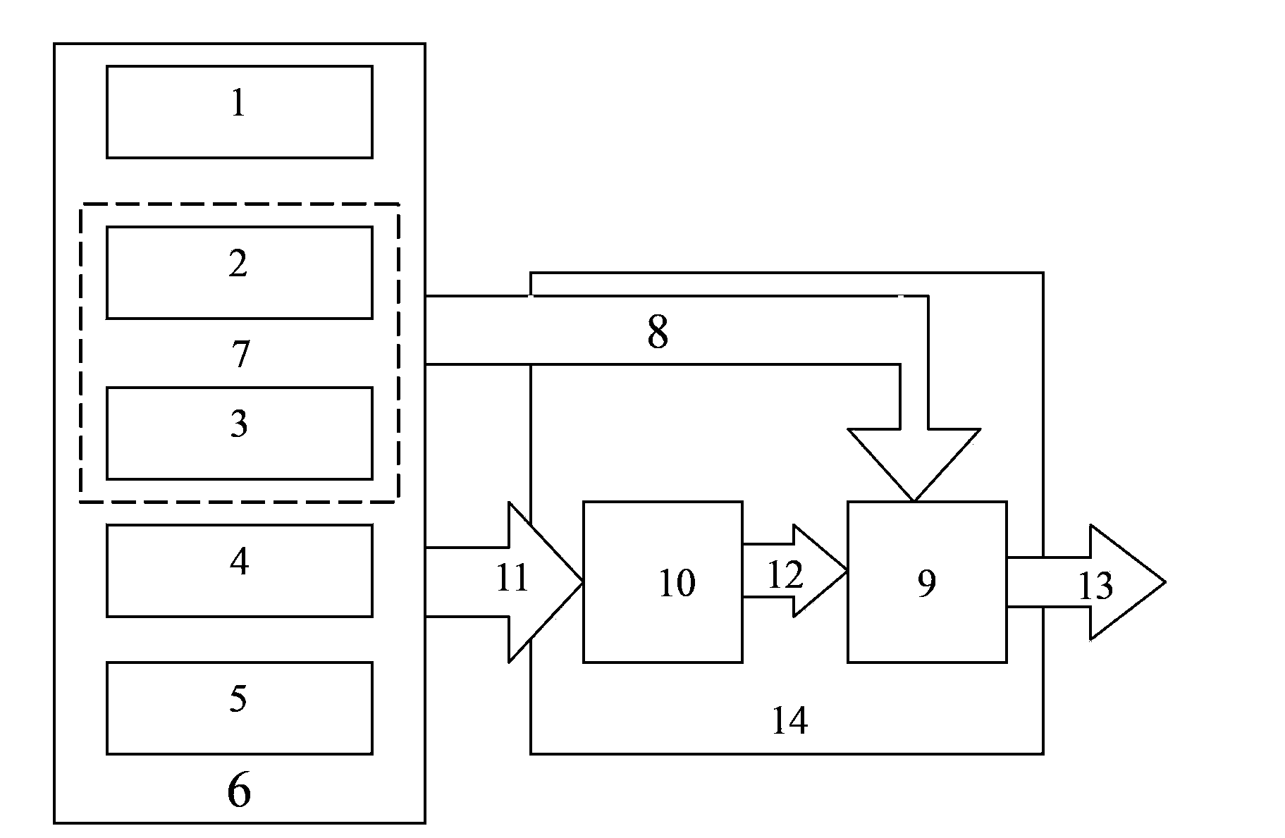
[0041] The structure of the integrated navigation system of inertial system and laser rangefinder is as follows: figure 1 As shown, the sensor part includes a laser rangefinder, an IMU, a barometric altimeter and a magnetic field strength sensor, wherein the IMU inertial measurement unit includes a gyroscope and an accelerometer, and the laser rangefinder transmits the surrounding environment information to the navigation computer through the USB bus; the rest of the sensors The collected data is transmitted to the conversion device through the electrical connection to obtain the data format that the navigation computer can use; the navigation computer calculates and obtains the navigation information through the improved combined navigation method proposed by the present invention.

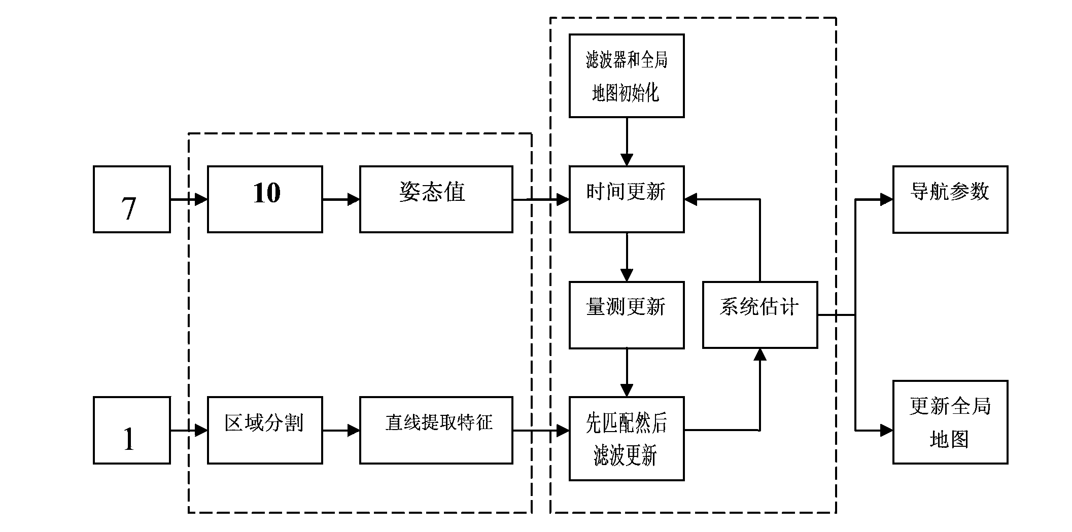
[0042] The algorithm flow chart of the inertial system and laser range ...


PUM


Abstract

The invention relates to an indoor-flying intelligent body inertial system and a laser range finder combination type navigation improving method. The navigation improving method is characterized in that a sensor portion (6) comprises a laser range finder URG (1), an IMU (Inertial Measurement Unit) (7), an atmospheric pressure altimeter (4), a magnetic field intensity sensor (5), a gyroscope (2) and an accelerometer (3); a navigation information calculation portion (14) comprises a USB (Universal Serial Bus) (8), a navigation computer (9), a converting device (10), an electric collecting line (11), a bus (12) and navigation information (13). The navigation improving method comprises the steps of acquiring position information by utilizing the laser range finder (1), acquiring attitude information by utilizing an inertial navigation system, fusing the position information with the attitude information by utilizing a unscented Kalman filter (UKF) method and a linear feature extraction algorithm, and finally performing a strapdown algorithm to realize track plotting. According to the navigation improving method, the indoor autonomous navigation of a flying intelligent body can be realized, the divergence and track plotting invalidation problems of a flying intelligent body combination type navigation system are effectively solved, and the navigation accuracy is improved.

Description

Technical field: [0001] The invention belongs to the field of multi-sensor information fusion. Background technique [0002] Inertial navigation is a track reckoning algorithm, which measures the specific force and angular rate of the carrier through the accelerometer and gyroscope, and uses the integral algorithm to solve the position and orientation information of the carrier. Strap-down Inertial Navigation System (SINS) is a kind of inertial navigation, which can continuously provide the pose information of the carrier. However, inertial navigation systems have the disadvantage of rapidly accumulating errors over time. Global Positioning System (Global Positioning System, GPS) and SINS have excellent complementarity, use GPS and SINS to carry out integrated navigation, can reduce cost and provide global precise navigation capability, therefore, SINS / GPS integrated navigation system has been widely used application. [0003] However, in the indoor environment, the GPS s...

Claims


Application Information

Patent Timeline
IPC IPC(8): G01C21/00G01C21/16G01C21/20
CPCG01C21/165G01C21/206
Inventor 王璐廖粤峰赵自超许可李冰马涛
Owner 南京恒誉名翔科技有限公司
Why Eureka
Try Eureka