Seed production base three-dimensional (3D) visualization geographic information system

A technology of geographic information system and geographic location information, applied in the field of geographic information system, can solve the problems of declining quality of seed products and insufficient monitoring, and achieve the effect of ensuring normal development and national food planting safety.

Inactive Publication Date: 2014-05-28
GANSU NEW SPACE INFORMATION TECH CORP LTD
View PDF2 Cites 17 Cited by
  • Summary
  • Abstract
  • Description
  • Claims
  • Application Information

AI Technical Summary

Problems solved by technology

There are quality and safety risk factors lurking in every link of the entire seed production. On the one hand, in the process of seed breeding and planting, the quality and safety of seed products are caused by the experience and technology of producers or driven by interests; Insufficient monitoring of data such as the environment and real-time growth conditions often leads to a decline in the quality of seed products

Method used


Image

  • Seed production base three-dimensional (3D) visualization geographic information system
  • Seed production base three-dimensional (3D) visualization geographic information system
  • Seed production base three-dimensional (3D) visualization geographic information system

Examples


Embodiment Construction

[0020] The present embodiment will be further described below in conjunction with the accompanying drawings.

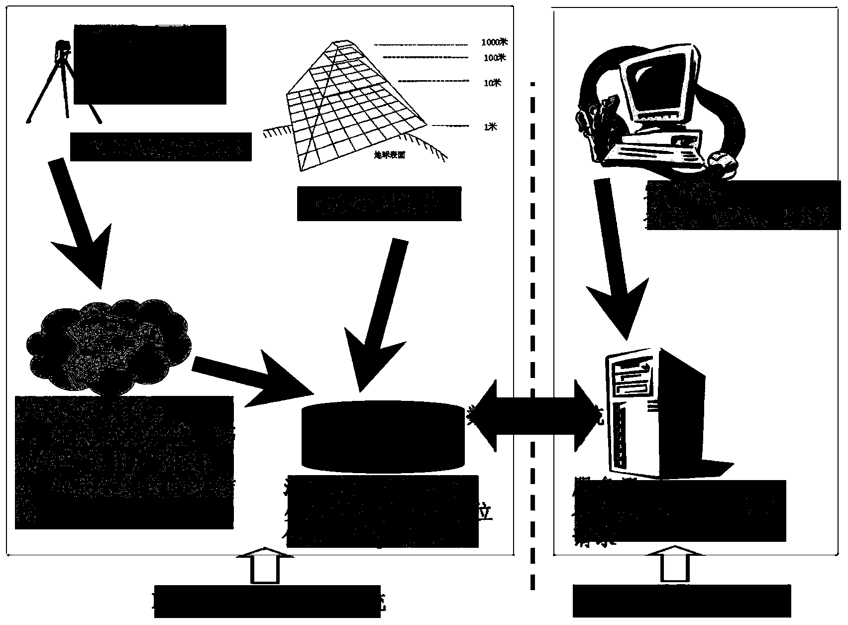
[0021] see figure 1 , is a block schematic diagram of the composition of the three-dimensional visualization geographic information system of the seed production base of the present invention. The three-dimensional visualization geographic information system of the seed production base provided by the present invention includes a shooting device, a GPS (global positing system) positioning device, a three-dimensional laser point cloud scanner, a three-dimensional image generation unit, a three-dimensional map model generation unit, a storage unit and a display subsystem The photographing device is used to obtain the real image of the seed base, and the GPS positioning device is used to record the geographic position information of each moving point of the photographing device while the photographing device obtains the real image; the three-dimensional laser point cloud...


PUM


Abstract

A seed production base three-dimensional (3D) visualization geographic information system comprises a shooting device, a GPS (global positioning system) positioning device, a 3D laser-point cloud scanner, a 3D image generating unit, a 3D map model generating unit, a storage unit and a display subsystem; the shooting device is used for obtaining a realistic image of a seed base; the GPS positioning device is used for recording the geographic position information of each moving point when the shooting device obtains the realistic image; the 3D laser-point cloud scanner is used for collecting 3D spatial data of the seed base when the shooting device obtains the realistic image; the 3D image generating unit is used for compounding a 3D realistic video according to the realistic picture and the geographic position information; the 3D map model generating unit is used for generating a 3D map model according to the 3D spatial data of the base; the storage unit is used for storing the 3D realistic video, the geographic position information and the 3D map model; the display subsystem is used for displaying the 3D realistic image and the 3D map model.

Description

technical field [0001] The invention relates to the field of geographic information system (Geographic Information System, GIS), in particular to a three-dimensional visualized geographic information system for a seed production base. Background technique [0002] With the development of our country's economy and the promotion of agricultural technology, the varieties of seed products are abundant and sufficient in quantity, but at the same time, hidden dangers in quality are worrying. There are quality and safety risk factors lurking in every link of the entire seed production. On the one hand, in the process of seed breeding and planting, the quality and safety of seed products are caused by the experience and technology of producers or driven by interests; Insufficient monitoring of data such as the environment and real-time growth conditions also often leads to a decline in the quality of seed products. Contents of the invention [0003] In view of this, it is necessa...

Claims


Application Information

Patent Timeline
Patent Type & Authority Applications(China)
IPC IPC(8): G06F17/30G06Q10/06G06Q50/02
CPCG06F16/29G06Q10/0637G06Q50/02
Inventor 冉永迪冉有华高亚军邱鹏飞赵益寿
Owner GANSU NEW SPACE INFORMATION TECH CORP LTD
Why Eureka
Try Eureka