Real-time measuring method of carrier attitude in transverse coordinate system of inertial navigation system

A technology of inertial navigation system and abscissa system, which is applied in the field of real-time measurement of body attitude in the abscissa system of inertial navigation system, and can solve the problem that the navigation solution method of inertial navigation system is not applicable.

Inactive Publication Date: 2014-07-23
HARBIN ENG UNIV
View PDF4 Cites 11 Cited by
  • Summary
  • Abstract
  • Description
  • Claims
  • Application Information

AI Technical Summary

Problems solved by technology

[0005] The purpose of the present invention is to provide a real-time measurement method of the attitude of the body in the abscissa system of the inertial navigation system in order to solve the problem that the navigation solution method of the conventional inertial navigation system is not applicable when the ship enters the polar region.

Method used


Image

  • Real-time measuring method of carrier attitude in transverse coordinate system of inertial navigation system
  • Real-time measuring method of carrier attitude in transverse coordinate system of inertial navigation system
  • Real-time measuring method of carrier attitude in transverse coordinate system of inertial navigation system

Examples


Embodiment Construction

[0028] The present invention will be further described below in conjunction with the accompanying drawings.

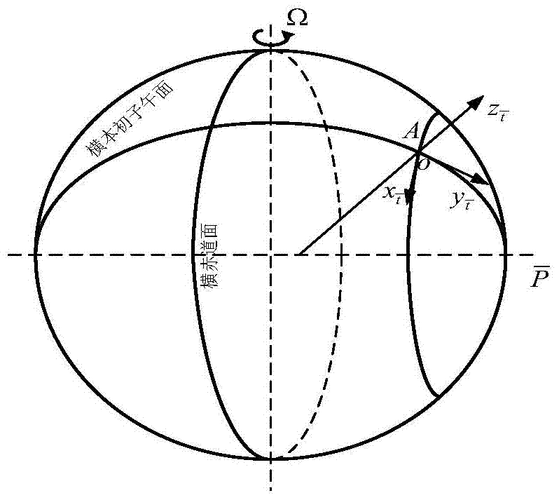
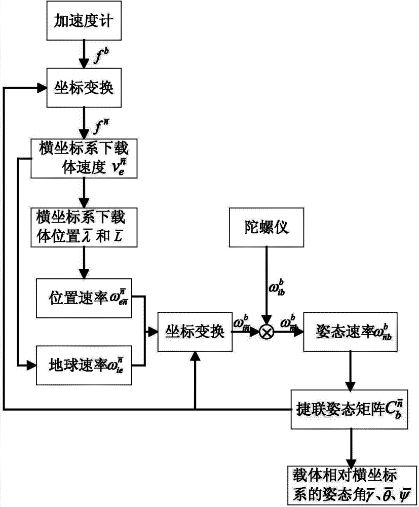
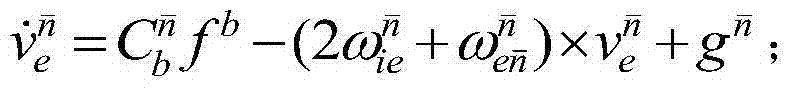
[0029] The problem solved by the technology of the present invention is: in order to solve the problem that the navigation calculation method of the conventional inertial navigation system is not applicable when the ship enters the polar region, the present invention proposes a real-time measurement of the body attitude in the abscissa system of the inertial navigation system Measurement methods. When the ship sails to a high-latitude area, the navigation coordinate system is converted from the geographic coordinate system to the horizontal geographic coordinate system, and the output value of the inertial measurement element is converted to the horizontal geographic coordinate system. Through the method involved in the present invention, the relative horizontal position of the carrier can be measured in real time. The attitude angle of the geographic coordinate system...


PUM


Abstract

The invention belongs to the technical field of polar region navigation of an inertial navigation system, in particular relates to a real-time measuring method of carrier attitude in a transverse coordinate system of the inertial navigation system, wherein the inertial navigation system uses the relationship of an inertial measurement unit output value in a transverse geographic coordinate system for real-time measuring of an attitude angle of a carrier relative to the transverse coordinate system. The real-time measuring method is as follows: measuring the transverse speed of the carrier; updating the transverse longitude and transverse geographic latitude of the position of a ship; obtaining a projection of earth's angular velocity in the navigation system in a polar region mode; obtaining a projection of angular velocity of a navigation coordinate system relative to an inertial coordinate system in a carrier coordinate system; obtaining angular velocity of the carrier relative to the navigation system; measuring a strapdown attitude matrix of the carrier; and measuring the attitude angle of the carrier relative to the transverse coordinate system. The real-time measuring method can realize High altitude real-time navigation, provides a mathematical model for a high latitude strapdown inertial navigation system, and avoids the problem that a common inertial navigation system cannot navigate in a high latitude region for the reason of calculation overflow.

Description

technical field [0001] The invention belongs to the technical field of inertial navigation system polar region navigation, and specifically relates to an inertial navigation system that uses the relationship between the output value of an inertial measurement unit in the horizontal geographic coordinate system to measure the attitude angle of the carrier relative to the horizontal coordinate system in real time. A method for real-time measurement of body attitude in the abscissa system. Background technique [0002] The inertial navigation system is a navigation device that uses gyroscopes and accelerometers to measure the angular motion and linear motion of the carrier, and obtains the instantaneous attitude, velocity and position of the carrier through integral calculations. It completely relies on its own sensitive devices to complete navigation tasks without relying on any external Information does not radiate any energy outside, it is a completely autonomous navigation ...

Claims


Application Information

Patent Timeline
Patent Type & Authority Applications(China)
IPC IPC(8): G01C21/16
CPCG01C21/16G01C21/203
Inventor 于飞阮双双鲍桂清奔粤阳赵维珩杨晓龙李敬春
Owner HARBIN ENG UNIV
Why Eureka
Try Eureka