Electric transmission line three-dimensional design method based on Google Earth and electric transmission line three-dimensional design system based on Google Earth

A technology of transmission lines and Google Earth, applied in computing, electrical digital data processing, instruments, etc., to reduce data dependence, facilitate data acquisition, and reduce dependence

Active Publication Date: 2014-07-30
SHENZHEN POWER SUPPLY PLANNING DESIGN INST +1
View PDF4 Cites 19 Cited by
  • Summary
  • Abstract
  • Description
  • Claims
  • Application Information

AI Technical Summary

Problems solved by technology

[0009] However, at present, there is no Google Earth-based 3D design method and system for transmission lines with convenient, fast and low-cost data acquisition in the industry.

Method used


Image

  • Electric transmission line three-dimensional design method based on Google Earth and electric transmission line three-dimensional design system based on Google Earth
  • Electric transmission line three-dimensional design method based on Google Earth and electric transmission line three-dimensional design system based on Google Earth
  • Electric transmission line three-dimensional design method based on Google Earth and electric transmission line three-dimensional design system based on Google Earth

Examples


Embodiment 1

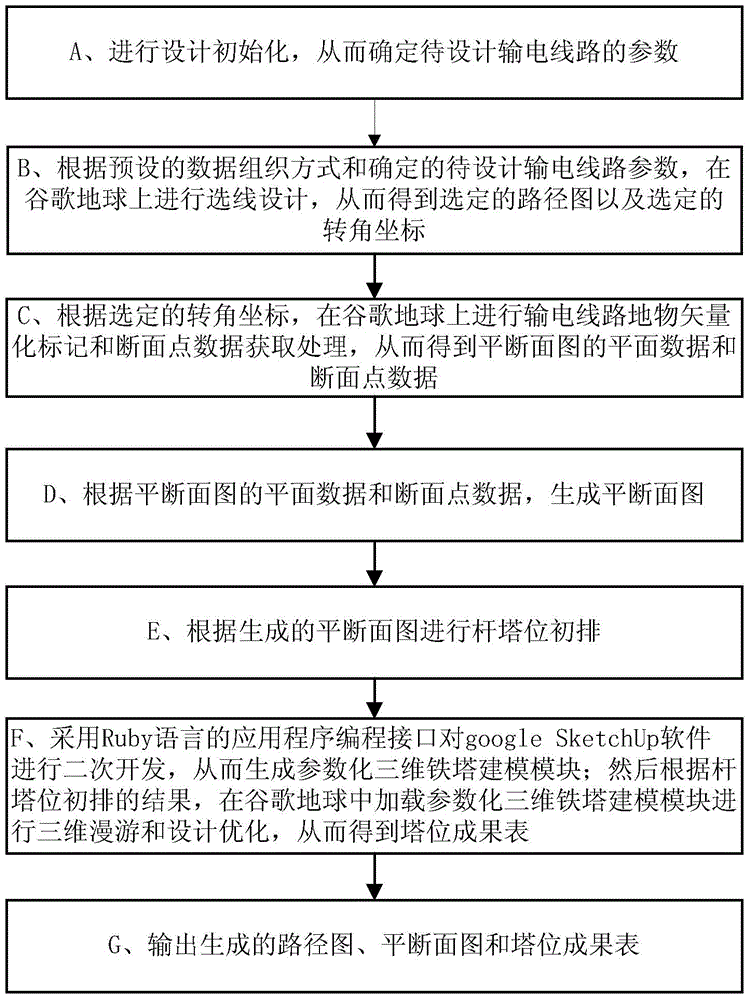
[0132] refer to Figure 9 , the present invention uses Google Earth and Google Maps to carry out the concrete process of transmission line three-dimensional design comprising:

[0133] (1) Initialization: New construction, customized design standards;

[0134] For new construction projects, determine the transmission line parameters such as line voltage level, sideline distance, and elevation point sampling interval to be designed.

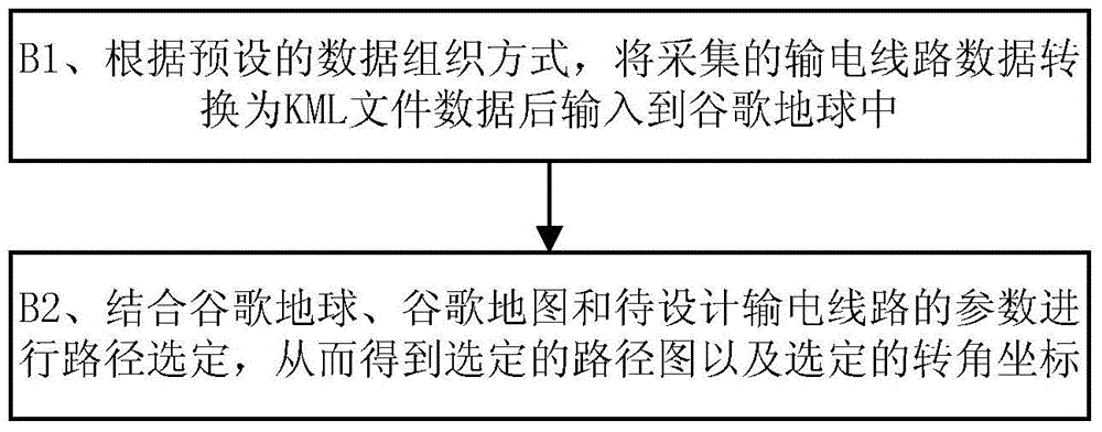
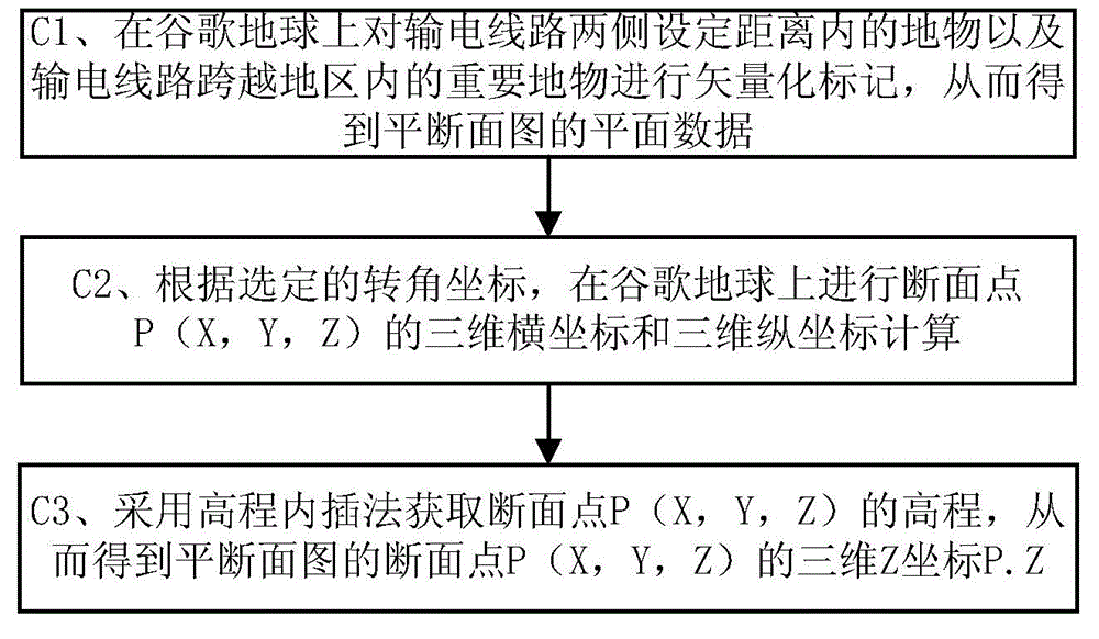
[0135] (2) Carry out line selection design on Google Earth to output the corner coordinates;

[0136] Open the software Google Earth software, and collect the planned high-voltage corridors,

[0137] The planning and status data that affect route selection, such as the direction of existing transmission lines, gas pipelines, oil pipelines, radio monitoring stations, microwave transmitters, and major industrial and mining areas, are input into Google Earth.

[0138] The Google Earth data exchange format is mainly a KML file. The present inventio...

Embodiment 2

[0154] This embodiment introduces three preset data organization modes of the present invention. The three data organization methods preset in the present invention include:

[0155] a. For point objects such as microwave launch stations, the data organization method is as follows:

[0156]

[0157] roll call

[0158] 0

[0159]

[0160] longitude

[0161] latitude

[0162] elevation

[0163] 0

[0164] Angle of view

[0165] relativeToSeaFloor

[0166]

[0167] # point markers

[0168]

[0169] longitude, latitude, elevation

[0170]

[0171]

[0172]

[0173] b. Linear features such as power lines and pipelines, the data organization of which is:

[0174]

[0175] line name

[0176] 0

[0177] # line style

[0178]

[0179]

[0180] Longitude, Latitude, Elevation, Longitude, Latitude, Elevation... (string of node coordinates f...


PUM


Abstract

The invention discloses an electric transmission line three-dimensional design method based on a Google Earth and an electric transmission line three-dimensional design system based on a Google Earth. The method comprises the following steps: designing initialization, thereby determining parameters of a to-be-designed electric transmission line; performing wire selection design on the Google earth according to the preset data organization mode and the parameters of the to-be-designed electric transmission line, thereby obtaining a selected path graph and selected corner coordinates; performing electric transmission line ground object vectorization marking and profile point data acquisition treatment on the Google earth according to the selected corner coordinates; generating a flat profile graph; performing pole tower position primary exclusion according to the generated flat profile graph; generating a parametrization three-dimensional iron tower modeling module, and loading the parametrization three-dimensional iron tower modeling module in the Google earth and performing three-dimensional roaming and design optimization, thereby obtaining a tower position outcome table; outputting the generated path graph, flat profile graph and tower position outcome table. The electric transmission line three-dimensional design method has the advantages of convenience and rapidness in data acquisition and low cost, and can be widely applied to the technical field of power engineering.

Description

technical field [0001] The invention relates to the technical field of electric power engineering, in particular to a Google Earth-based three-dimensional design method and system for transmission lines. Background technique [0002] Glossary: [0003] Ruby language: an object-oriented, imperative, functional, and dynamic general-purpose programming language, designed and developed by Japanese Matsumoto Yukihiro in the mid-1990s. [0004] Google SketchUp software: Google SketchUp software is a free 3D design software provided by Google. [0005] Power line selection should comprehensively consider natural and geographical conditions as well as economic and social factors. Therefore, a topographic map with high reality is required as the basis. The acquisition cycle of topographic map data is long and the cost is high. [0006] When designing traditional transmission lines, designers need to conduct site selection, line selection and project demonstration on the basis of to...

Claims


Application Information

Patent Timeline
Patent Type & Authority Applications(China)
IPC IPC(8): G06F17/50
Inventor 孙永旺李立陈清
Owner SHENZHEN POWER SUPPLY PLANNING DESIGN INST
Why Eureka
Try Eureka