Multi-source remote sensing image-based urban area elevation dimension change information extraction method

A technology for changing information and elevation, applied in height/horizontal measurement, measuring devices, instruments, etc., can solve the problems that the detection results cannot be true, accurately reflect the change of the elevation dimension of the ground object information, and do not consider the deformation of the urban surface, etc., to eliminate Influence and improve the effect of detection accuracy

Inactive Publication Date: 2014-08-27
NAT GEOMATICS CENT OF CHINA
View PDF0 Cites 12 Cited by
  • Summary
  • Abstract
  • Description
  • Claims
  • Application Information

AI Technical Summary

Problems solved by technology

[0004] However, at present, the detection technology of elevation dimension changes in urban areas based on multi-source and multi-temporal remote sensing images is still in the exploratory stage at home and abroad. The research work that has just started abroad can only detect various types of ground objects distributed on the ur

Method used


Image

  • Multi-source remote sensing image-based urban area elevation dimension change information extraction method
  • Multi-source remote sensing image-based urban area elevation dimension change information extraction method

Examples


Embodiment Construction

[0035] The following examples are used to illustrate the present invention, but are not intended to limit the scope of the present invention.

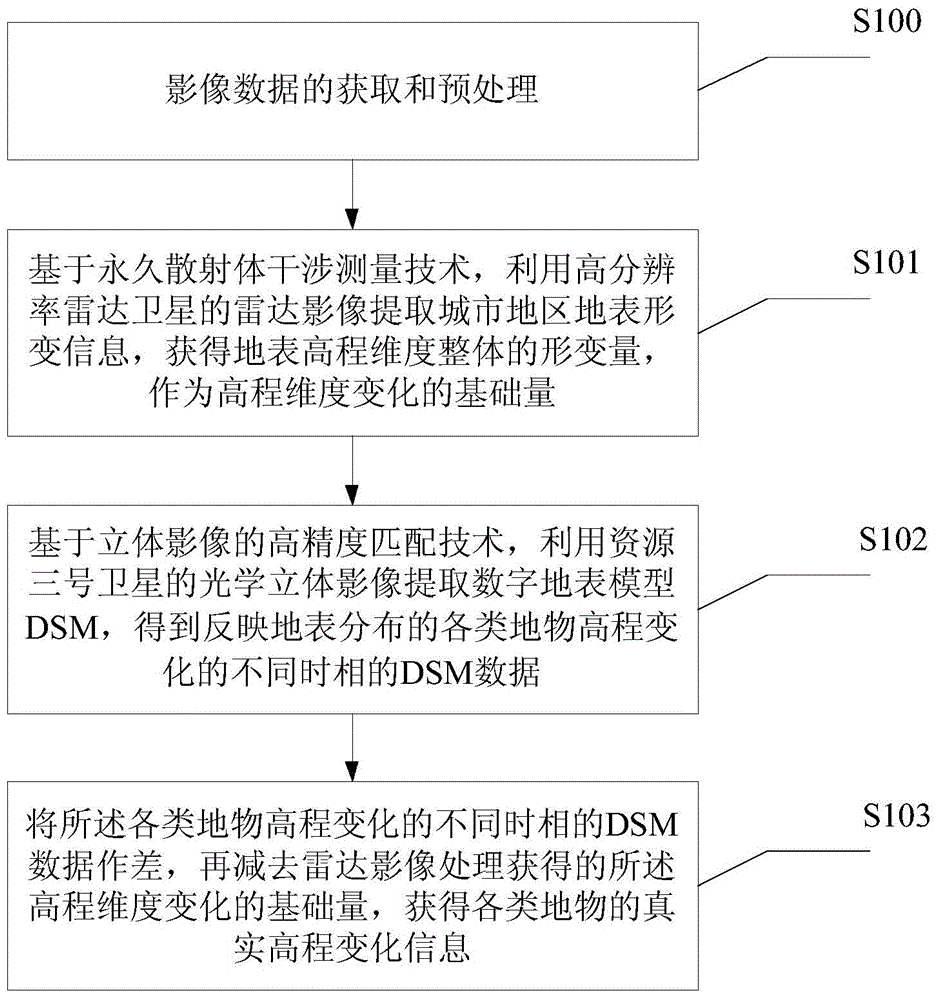
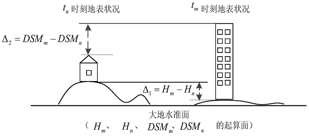
[0036] The present invention is based on PS-InSAR (PersistentScattererInterferometrySyntheticApertureRadar, permanent scatterer radar interferometry) technology, using COSMO-SkyMed (a high-resolution radar satellite launched by Italy) radar images to extract surface deformation information, and obtain the overall deformation of the surface elevation dimension as the elevation The basic amount of dimensional change; based on the high-precision matching technology of stereoscopic images, the DSM (Digital Surface Model, digital surface model) is extracted from the stereoscopic images of No. Data; the difference of DSM data in different time phases is subtracted from the surface settlement obtained by radar image processing, so as to obtain the real elevation change information of various ground objects.

[0037] figure 1 It is a flow cha...


PUM


Abstract

The invention relates to a multi-source remote sensing image-based urban area elevation dimension change information extraction method. The method comprises the following steps of 1, based on a PS-InSAR (permanent scatterer radar interferometry) technology, extracting earth's surface deformation information by a COSMO-SkyMed high-resolution ratio radar image, and acquiring surface elevation dimension whole-deformation quantity as elevation dimension change base quantity, 2, based on a stereo-image high-precision matching technology, by a source 3 stereo-image, extracting digital surface model (DSM) and acquiring different-time phase DSM data showing elevation changes of various ground objects distributed on the earth's surface, and 3, calculating the difference of the different-time phase DSM data, and subtracting a surface settlement value obtained by radar image processing to obtain real elevation change information of the various ground objects. The method provided by the invention can eliminate the influence produced by surface whole-deformation quantity on an elevation dimension change information detection result, and improves a detection precision.

Description

technical field [0001] The invention relates to the technical field of photogrammetry and remote sensing, in particular to a method for extracting elevation dimension change information in urban areas based on multi-source remote sensing images. Background technique [0002] Since the reform and opening up, China's urban landscape has undergone earth-shaking changes. It has experienced the transformation from the initial "pancake spread" type of area expansion to the "three-dimensional city" developed above the city in recent years. It is concentrated in the construction of high-rise buildings and the construction of three-dimensional transportation. Therefore, the extraction of elevation dimension change information in urban areas has important practical significance, and can more accurately reflect the development and changes of cities. [0003] Photogrammetry and remote sensing technology, with its "synchronous observation of a large area", "timeliness", and "data compreh...

Claims


Application Information

Patent Timeline
IPC IPC(8): G01C5/00
CPCG01C5/00
Inventor 高志宏周旭李力勐陶舒程滔杨靓刘倩周琦
Owner NAT GEOMATICS CENT OF CHINA
Why Eureka
Try Eureka