Position information processing method, device and terminal

An information processing method and geographic information technology, applied in the field of devices and terminals, and location information processing methods, can solve problems such as low efficiency, cumbersome operation steps, and inconvenience

Active Publication Date: 2014-08-27
XIAOMI INC
View PDF4 Cites 12 Cited by
  • Summary
  • Abstract
  • Description
  • Claims
  • Application Information

AI Technical Summary

Problems solved by technology

However, in practical applications, users are more accustomed to using well-known geographical information (such as: countries, cities, neighborhoods, and scenic spots, etc.) to operate photos or videos, such as: clustering and displaying photos, or shooting for different scenic spots automatically add labels etc. to the photos, instead of memorizing the latitude and longitude coordinates of all locations. Therefore, when users perform the above operations, they usually...

Method used


Image

  • Position information processing method, device and terminal
  • Position information processing method, device and terminal
  • Position information processing method, device and terminal

Examples


Embodiment Construction

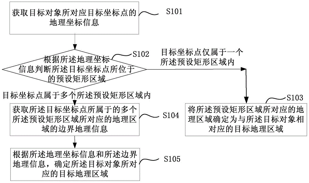
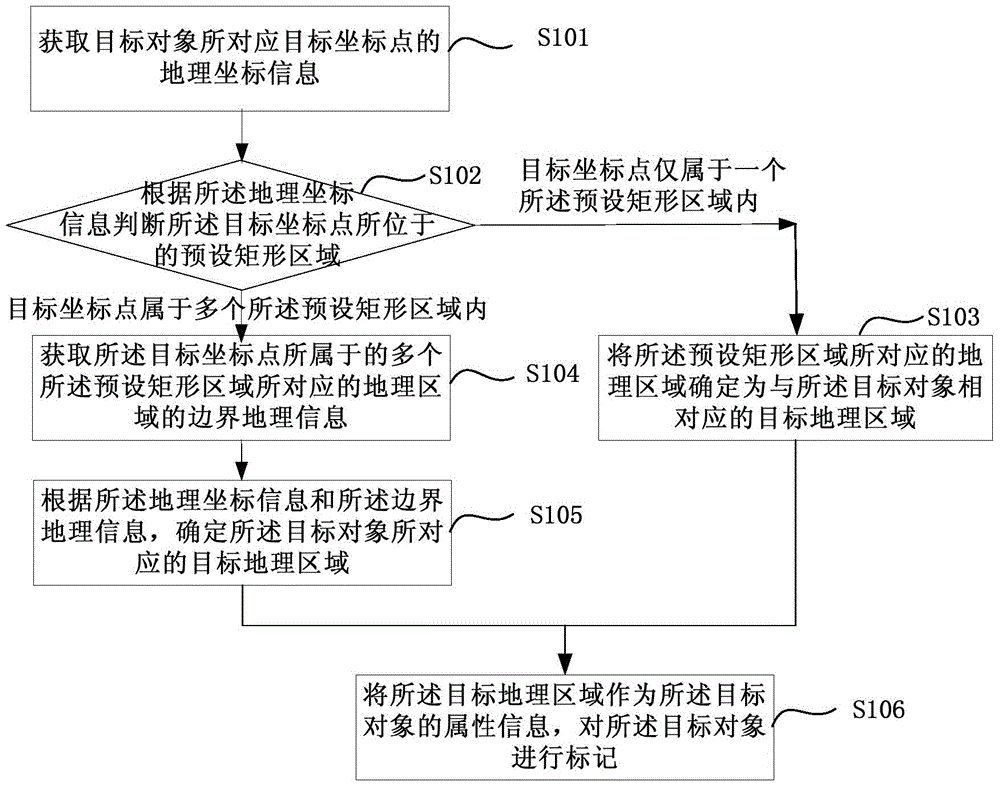
[0092] Reference will now be made in detail to the exemplary embodiments, examples of which are illustrated in the accompanying drawings. When the following description refers to the accompanying drawings, the same numerals in different drawings refer to the same or similar elements unless otherwise indicated. The implementations described in the following exemplary examples do not represent all implementations consistent with the present invention. Rather, they are merely examples of apparatuses and methods consistent with aspects of the invention as recited in the appended claims.

[0093] figure 1 is a flow chart of a position information processing method shown according to an exemplary embodiment, as shown in figure 1 As shown, the method is used in a terminal or a server, and includes the following steps.

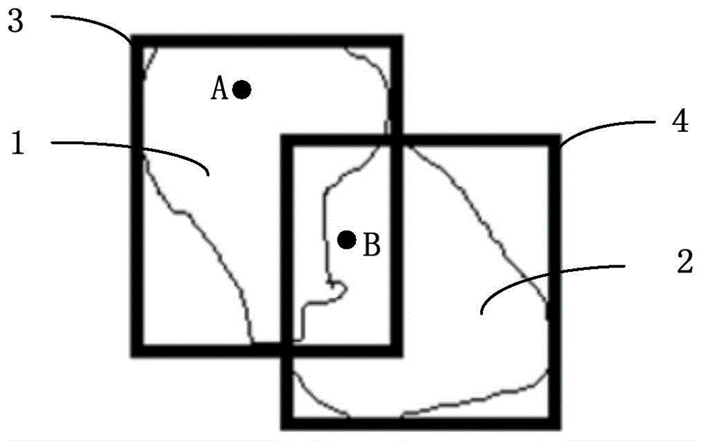
[0094] In step S101, the geographical coordinate information of the target coordinate point corresponding to the target object is acquired.

[0095] The target ob...


PUM


Abstract

The invention provides a position information processing method, device and terminal. The method comprises the following steps: acquiring geographic coordinate information of a target coordinate point corresponding to a target object; determining a preset rectangular area in which the target coordinate point is positioned; once the target coordinate point is in only one preset rectangular area, determining the geological area corresponding to the preset rectangular area as a target geological area corresponding to the target object; once the target coordinate point is in a plurality of preset rectangular areas, acquiring the boundary geological information of the geological areas corresponding to the plurality of preset rectangular areas in which the target coordinate point is positioned, and then determining the target geological area corresponding to the target object. According to the method, the rough positioning is first performed through the preset rectangular area; once the target geological area is failed to be determined by rough positioning, the existing positioning method is utilized to fine position, so as to reduce the calculation and time cost for positioning, as well as improve the positioning efficiency of the geological area in which the target object is positioned.

Description

technical field [0001] The present disclosure relates to the technical field of information processing, and in particular, to a location information processing method, device, and terminal. Background technique [0002] With the development of modern electronic technology, the use of wireless mobile terminals such as smart phones and tablet computers is becoming more and more popular, and the performance of cameras integrated on wireless mobile terminals is improving day by day. main tool. [0003] In order to prevent the user from forgetting the location where the photo was taken when browsing photos or videos, the wireless mobile terminal can also record the latitude and longitude coordinates of the location when the photo is taken. However, in practical applications, users are more accustomed to using well-known geographical information (such as: countries, cities, neighborhoods, and scenic spots, etc.) to operate photos or videos, such as: clustering and displaying phot...

Claims


Application Information

Patent Timeline
IPC IPC(8): G06F17/30
CPCG06F16/29G06F16/5866
Inventor 蔡经伟王楠江海
Owner XIAOMI INC
Why Eureka
Try Eureka