GNSS (Global Navigation Satellite System) ground operation path dynamic planning and navigation method based on forklift load monitoring

A technology of dynamic planning and navigation methods, applied in the direction of navigation calculation tools, etc., can solve the problems of inconvenient operations on flat ground, inability to reflect the real-time and flexibility of navigation, and reduce work efficiency.

Inactive Publication Date: 2014-09-03
CHINA AGRI UNIV
View PDF4 Cites 11 Cited by
  • Summary
  • Abstract
  • Description
  • Claims
  • Application Information

AI Technical Summary

Problems solved by technology

Under normal circumstances, only one or two of the principles can be guaranteed to be optimal according to the actual situation; and the navigation method realized by using these planning principles emphasizes the overall planning, and does not take into account the real-time changes of the terrain during the leveling process and the operator's different navigation commands. Taking into account the factors of obedience, it cannot reflect the real-time and flexibility of navigation
At the same time, in the previous leveling process, the leveling operator frequently observed the soil load in the forklift to judge the tractor's walking direction, which greatly reduced work efficiency and also caused inconvenience to the operator when leveling.

Method used


Image

  • GNSS (Global Navigation Satellite System) ground operation path dynamic planning and navigation method based on forklift load monitoring
  • GNSS (Global Navigation Satellite System) ground operation path dynamic planning and navigation method based on forklift load monitoring
  • GNSS (Global Navigation Satellite System) ground operation path dynamic planning and navigation method based on forklift load monitoring

Examples


Embodiment Construction

[0065] The present invention will be described in further detail below in conjunction with the accompanying drawings and embodiments. The following examples are used to illustrate the present invention, but should not be used to limit the scope of the present invention.

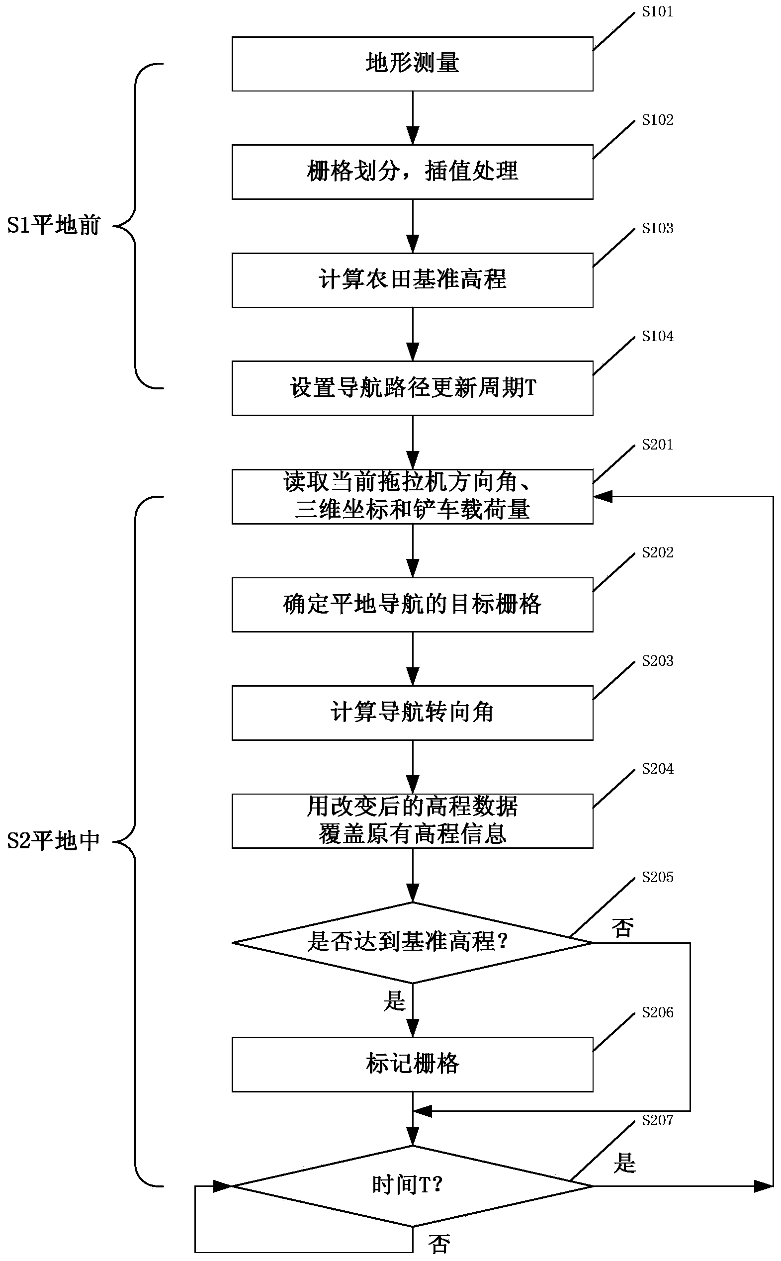
[0066] figure 1 It is a flow chart of the GNSS level ground operation path dynamic planning and navigation method based on forklift load monitoring of the present invention; the method includes the following steps:

[0067] S1. Before level ground,

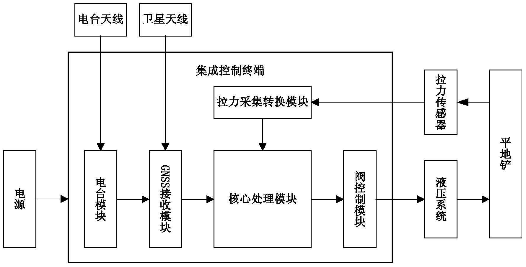
[0068] S101, terrain data collection; loading such as figure 2 The forklift of the shown GNSS intelligent control leveling system calibrates the three-dimensional coordinates of the origin, performs boundary measurement and internal measurement, and saves the farmland terrain data in the form of relative coordinates, that is, the elevation value, relative to the three-dimensional coordinates of the origin;

[0069] S102. Carry out grid division on the farmlan...


PUM


Abstract

The invention discloses a GNSS (Global Navigation Satellite System) ground operation path dynamic planning and navigation method based on forklift load monitoring. The method comprises the following steps before leveling and during leveling: before leveling, performing topographic survey, grid division and interpolation processing, calculating a farmland datum elevation, and setting an update cycle T of a navigation path; starting leveling, reading a three-dimensional coordinate of a grid position at which a forklift is placed, a current moving direction angle and the load capacity of the forklift at every time T, and calculating an object grid and a steering angle; covering original data by use of a new elevation value of changed topography in the walking process of the forklift; in order to avoid repeated walking for multiple times, marking the grid which reaches the accuracy requirement of the datum elevation. By using the method, the whole optimal planning and the real-time optimal planning are realized; the walking distance of the tractor in the whole leveling process is shortened; the leveling efficiency is improved; the problems of fixity of a path planning mode and lack of real-time feedback of planning and decision in a traditional technique are solved.

Description

technical field [0001] The invention relates to the technical field of path navigation in land leveling, and more particularly to a GNSS leveling operation path dynamic planning and navigation method based on forklift load monitoring. Background technique [0002] Farmland land leveling can improve the topography of the farmland surface, improve the irrigation efficiency and irrigation uniformity of the farmland, and achieve the effect of saving water and increasing production. Fine land leveling plays a positive and far-reaching role in promoting water resources management and agricultural modernization. As a kind of intelligent land leveling technology, GPS controlled leveling technology has developed rapidly at home and abroad, and commercialized products have been produced in the United States. The domestic GNSS control leveling system uses high-precision and highly integrated GPS+BDS dual-star positioning equipment to replace foreign high-cost GPS receiving equipment, ...

Claims


Application Information

Patent Timeline
Patent Type & Authority Applications(China)
IPC IPC(8): G01C21/20
CPCG01C21/20
Inventor 刘刚王岩牛东岭李宏鹏李笑司永胜
Owner CHINA AGRI UNIV
Why Eureka
Try Eureka