Dynamic clustering algorithm for geographic grids

A geographic grid and clustering algorithm technology, which is applied in computing, electrical digital data processing, special data processing applications, etc., can solve problems such as neglect, small number of data points, long clustering time, etc., and achieve high flexibility and speed Efficient effect

Inactive Publication Date: 2014-09-03
FENGHUO COMM SCI & TECH CO LTD
View PDF0 Cites 5 Cited by
  • Summary
  • Abstract
  • Description
  • Claims
  • Application Information

AI Technical Summary

Problems solved by technology

If the division granularity of the lowest layer of the grid structure is relatively coarse and the number of grid units is relatively small, the clustering time will be reduced and the clustering speed will be fast, but the coarse granularity will reduce the clustering accuracy; on the contrary, if the grid structure If the division granularity of the lowest layer is finer, higher clustering accuracy will be obtained, but at the same time the processing overhead will increase, resulting in longer clustering time
On the other hand, if the division

Method used


Image

  • Dynamic clustering algorithm for geographic grids
  • Dynamic clustering algorithm for geographic grids

Examples


Embodiment Construction

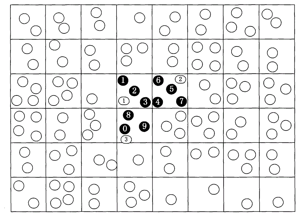
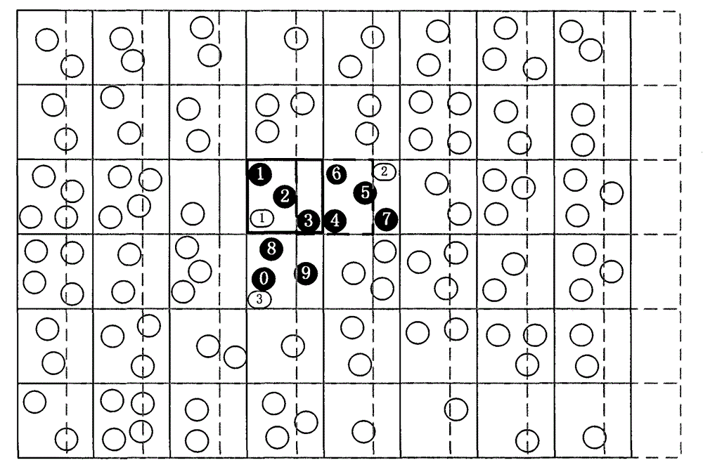
[0020] A kind of dynamic geographic grid clustering algorithm described in this patent application, when realizing this method, find out maximum and minimum latitude and longitude in an area where latitude and longitude points occur, for example, existing P1-Pn points P1(x1, y1), P2(x2, y2), ...Pn(xn, yn), first take out the maximum and minimum latitude and longitude (Xmax, Xmin, Ymax, Ymin) among the P1-Pn points; The area between the minimum longitude and latitude is divided into grids, and the number of the grid where each point is located is calculated. In aggregated data analysis, adjust the size of the step length by combining the size of the area, the distribution of points, and the clustering accuracy. For example, when the area is large and the distribution of points is sparse, the step length should be slightly larger. Otherwise, the area When the range is small, and the distribution of points is dense, and the clustering accuracy is high, the step length should be s...


PUM


Abstract

The invention discloses a dynamic clustering algorithm for geographic grids. The method includes the steps that firstly, the maximum longitude and latitude and the minimum longitude and latitude are found out in an area, and then according to the step length, grid division is performed on the area between the maximum longitude and latitude and the minimum longitude and latitude; serial numbers of the grids where all points are located are calculated, the points in the same grid are clustered, and the gravity center of clustering is calculated; then the grids are moved in the vertical direction and the horizontal direction, the moving lengths are kept uniform, the frequencies of moving in the directions mutually symmetrical are kept uniform, the sequence of the moving directions is not limited, after moving each time, the points, meeting clustering conditions, in the grids are clustered, and all the clustered points form a final clustered result. According to the method, the problems that a traditional clustering algorithm based on the grids is low in precision and efficiency are solved, the grids can be drawn dynamically through the method, the granularity can be freely controlled, flexibility is high, and the speed is high.

Description

technical field [0001] The application belongs to the technical field of data mining and relates to cluster analysis, in particular to a cluster analysis algorithm of a dynamic geographical grid. Background technique [0002] Cluster analysis is one of the widely researched topics in data mining. It is to find the similarity between data from the data, and classify the data accordingly, so as to discover the useful information or knowledge hidden in the data. Grid method is a commonly used method for discretizing spatial data in spatial data processing. Grid-based clustering algorithms are widely used in clustering algorithms because they are easy to implement incrementally and process high-dimensional data. [0003] Traditional geographic grid maps are a relatively simple type of map. The map area is divided into grids according to plane coordinates or latitude and longitude, and the geographic location information is described in units of grids. Extending this specific d...

Claims


Application Information

Patent Timeline
IPC IPC(8): G06F19/00
Inventor 凌晨胡亮邢长胜何宇
Owner FENGHUO COMM SCI & TECH CO LTD
Why Eureka
Try Eureka