Building roof reconstruction method based on airborne LiDAR data

A building and data technology, applied in 3D modeling, image data processing, instruments, etc., can solve problems such as inability to judge segmentation results, missing point clouds, and merging errors

Active Publication Date: 2014-09-10
AERIAL PHOTOGRAMMETRY & REMOTE SENSING CO LTD
View PDF4 Cites 55 Cited by
  • Summary
  • Abstract
  • Description
  • Claims
  • Application Information

AI Technical Summary

Problems solved by technology

[0004] First, the model library is incomplete: the architectural style of complex buildings is difficult to estimate, and it is difficult to combine the simple collection models of the model library into a real building model;
[0005] Second, the building itself is difficult to decompose: the algorithm is aimed at point cloud data types, and it is difficult to decompose complex buildings through spatial set analysis;
[0006] Third, when selecting model units, the matching of parameters is difficult to determine: different point cloud data densities are different, and the shape of the intermediate model in the database also has certain repetitions, so it is difficult to determine the selection of model units through parameters
[0008] First, the data requirements are complex: as disclosed in the invention patent application document with the publication number CN102521884A, the

Method used


Image

  • Building roof reconstruction method based on airborne LiDAR data
  • Building roof reconstruction method based on airborne LiDAR data
  • Building roof reconstruction method based on airborne LiDAR data

Examples


Embodiment Construction

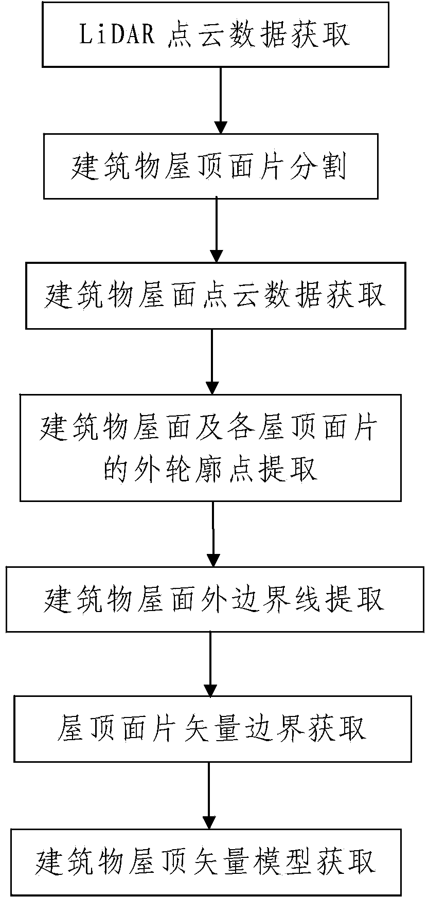
[0112] Such as figure 1 A method of building roof reconstruction based on airborne LiDAR data is shown, including the following steps:

[0113] Step 1, LiDAR point cloud data acquisition: use the airborne LiDAR measurement system to obtain the point cloud data of the area to be measured, and transmit the acquired point cloud data to the data processing device; the point cloud data includes multiple points in the area to be measured The point cloud data of each building roof, the point cloud data of each building roof includes multiple measuring points on the building roof and the three-dimensional coordinates of each measuring point.

[0114] In this embodiment, before processing the LiDAR point cloud data, the acquired point cloud data is filtered by setting an elevation threshold, and the point cloud data of other features other than buildings need to be processed in the point cloud data. At the same time, it is necessary to classify the filtered point cloud data to find ou...


PUM


Abstract

The invention discloses a building roof reconstruction method based on airborne LiDAR data. The method comprises the steps of 1, obtaining LiDAR point cloud data, and 2, processing the LiDAR point cloud data; the step 2 comprises the processes of 201, dividing building roof patches to obtain a plurality of roof patches from the building roof, 202, obtaining building roof point cloud data, 203, extracting outer contour points of the building roof and the roof patches, and meanwhile, extracting the outer boundary line of the building roof, 204, obtaining the vector boundaries of the roof patches, including establishing a search information set, carrying out neighborhood search, determining the types of the outer contour points and determining the vector boundaries, and 205, obtaining a vector model of the building roof, namely obtaining the vector model of the building roof after determining the vector boundaries of the plurality of roof patches. The method is simple in steps, reasonable in design and convenient to realize, good in using effect, and capable of completing the reconstruction processes of the building roof simply, conveniently and quickly with high quality.

Description

technical field [0001] The invention relates to a building roof modeling method, in particular to a building roof reconstruction method based on airborne LiDAR data. Background technique [0002] 3D building models are widely used in digital city fields such as urban and regional planning, transportation planning, population estimation and forecasting, pollution analysis, and energy budgeting. Traditional 3D modeling methods mainly use photogrammetry and other surveying and mapping methods for urban modeling, which need to be measured in stereo image pairs. The extracted 3D models have problems such as low precision and poor quality, and are labor-intensive and costly. , long cycle and other shortcomings. [0003] At present, the modeling technology based on airborne Lidar data has made great progress. The ground point cloud is separated by data filtering, and then the vector model is obtained by processing the building point cloud. The main methods include model-driven met...

Claims


Application Information

Patent Timeline
IPC IPC(8): G06T17/00
Inventor 彭桂辉段梦琦杨培义宋袁龙
Owner AERIAL PHOTOGRAMMETRY & REMOTE SENSING CO LTD
Why Eureka
Try Eureka