Method for automatically identifying seabed sand wave features based on ODP
An automatic identification and feature line technology, applied in special data processing applications, instruments, electrical digital data processing, etc., can solve the problems of limitations and low recognition rate
- Summary
- Abstract
- Description
- Claims
- Application Information
AI Technical Summary
Problems solved by technology
Method used
Image
Examples
Embodiment 1
[0070] A method for automatic identification of seabed sand wave features based on ODP, comprising the following steps:
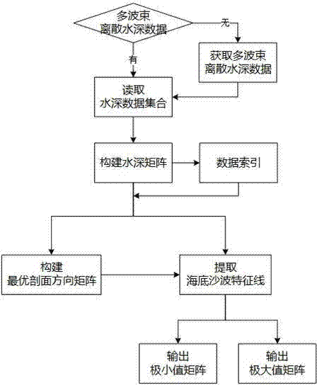
[0071] The schematic flow chart of the present invention is shown in figure 1 .
[0072] Step 1) Mapping digital water depth matrix
[0073] 1.1) Construct water depth matrix
[0074] 1.1.1) If there is no multi-beam discrete water depth data, use the full coverage measurement method to obtain multi-beam water depth data, obtain the multi-beam discrete data set MBES after data editing and correction processing, and enter step 1.1.2);
[0075] 1.1.2) If the multi-beam discrete water depth data set MBES, use the inverse distance weighting method to construct the water depth matrix Among them, G(i, j) is the water depth matrix point in row i and column j, nx is the total number of rows in the matrix, ny is the total number of columns in the matrix, and i, j, nx, and ny are all natural numbers;
[0076] 1.2) Construct data index of water depth matrix
[0...
Embodiment 2
[0122] In order to verify the validity and correctness of "a kind of automatic recognition method for seabed sand wave characteristics based on ODP", the technical process in Example 1 is used to select a representative sand wave area for experimentation. The specific process:
[0123] 1) Surveying and mapping digital water depth matrix: In the experiment, the sand wave data measured by the multi-beam bathymetry system is used to test the method. The high-precision water depth data adopts the R2Sonic2024 ultra-high resolution multi-beam sounding system. After data editing and correction processing, the multi-beam discrete data set is obtained, and the distance inverse weighting method is used to construct the water depth matrix in the sand wave area. Figure 4 ;
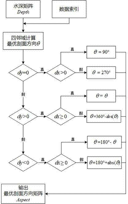
[0124] 2) Construct the optimal profile direction matrix: according to figure 2 In the steps shown, the optimal section direction matrix of the constructed sand wave area is Figure 5 ;
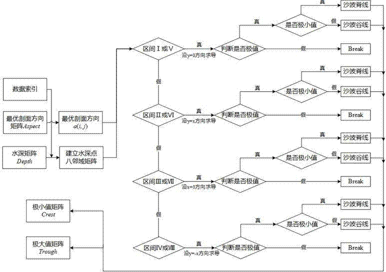
[0125] 3) Extract the ch...
Embodiment 3
[0129] In order to further verify the effectiveness and correctness of "an automatic recognition method for seabed sand wave characteristics based on ODP", the hydrological analysis method and the slope aspect variability analysis method were used to conduct comparative experiments on the same sand wave area in Example 2, and the statistics Under different classification threshold conditions, the hydrological analysis method and slope aspect variability analysis method extract the number of feature points in the sand wave area and the correlation coefficient with the manual identification feature line:
[0130] 1) The hydrological analysis method extracts the number of characteristic points of ridges and valleys in the sand wave area, and the correlation coefficient with the characteristic lines of manual identification is as follows: Figure 7 , where the maximum correlation coefficients between the ridgeline and valleyline in the sand wave area extracted by the hydrological a...
PUM
 Abstract
Description
Claims
Application Information
 - R&D
- Intellectual Property
- Life Sciences
- Materials
- Tech Scout
- Unparalleled Data Quality
- Higher Quality Content
- 60% Fewer Hallucinations
Browse by: Latest US Patents, China's latest patents, Technical Efficacy Thesaurus, Application Domain, Technology Topic, Popular Technical Reports.
© 2025 PatSnap. All rights reserved.Legal|Privacy policy|Modern Slavery Act Transparency Statement|Sitemap|About US| Contact US: help@patsnap.com


