

A Method for Automatically Drawing Meteorological Contours in the Sea-land Ecotone
An automatic drawing and contouring technology, applied in the field of value line drawing, can solve problems such as time-consuming and labor-intensive, troublesome drawing process, unable to solve special needs, etc., and achieve the effect of reducing confusion, complete information, and scientific distribution.
- Summary
- Abstract
- Description
- Claims
- Application Information
AI Technical Summary
Problems solved by technology
Method used
Image

Examples
Embodiment
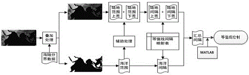
[0060] (1) Use the sea-land boundary data to do overlay analysis on the original data of the contour line, and separate the data of the ocean part
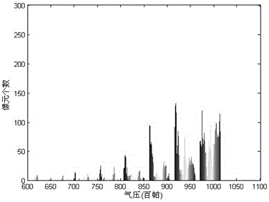
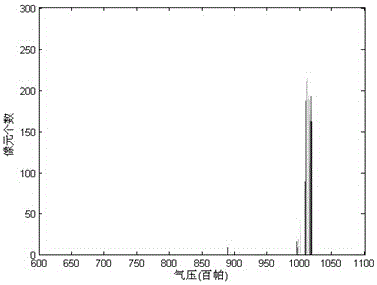
[0061] Take the numerical forecast product of apparent pressure in the Indian Ocean region at 12:00 on May 23, 2013 as an example. The longitude range is 30°E~125°E, the latitude range is 20°S~30°N, and the resolution is 476*251. Through the overlay analysis of the sea-land boundary data, the ocean and land data are separated. figure 2 It is a statistical chart of surface air pressure numerical forecast product data in land area. Analysis of the data shows that the air pressure value in land area ranges from 600-1100 hPa, and its distribution is in a zigzag shape, with several peaks in the interval from 850-1020. Decrease gradually to both sides. image 3 It is a statistical map of the surface pressure numerical forecast product data in the ocean area. The air pressure values in the ocean area are concentrated in the range of...
PUM
 Abstract
Description
Claims
Application Information