Low-altitude remote sensing image high-precision matching method with consistent image space

A technology of image space, low-altitude remote sensing, applied in the field of low-altitude remote sensing image matching, can solve the problems of geometric deformation, easy failure, low matching success rate, etc.

Inactive Publication Date: 2014-11-05
BEIJING AEROSPACE TITAN TECH CO LTD
View PDF1 Cites 22 Cited by
  • Summary
  • Abstract
  • Description
  • Claims
  • Application Information

AI Technical Summary

Problems solved by technology

[0004] In order to overcome the deficiencies of the above-mentioned prior art, the present invention provides a high-precision matching method for low-altitude remote sensing images with consisten

Method used


Image

  • Low-altitude remote sensing image high-precision matching method with consistent image space
  • Low-altitude remote sensing image high-precision matching method with consistent image space
  • Low-altitude remote sensing image high-precision matching method with consistent image space

Examples


Embodiment Construction

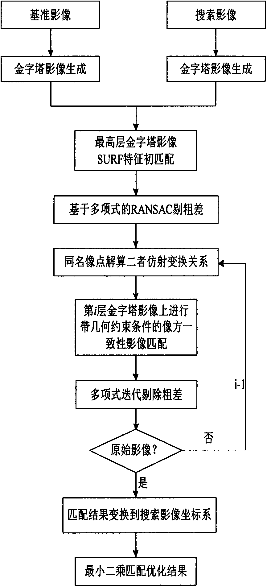
[0009] In order to make the object, technical solution and advantages of the present invention more clear, the present invention will be further described in detail below in conjunction with the accompanying drawings and embodiments.

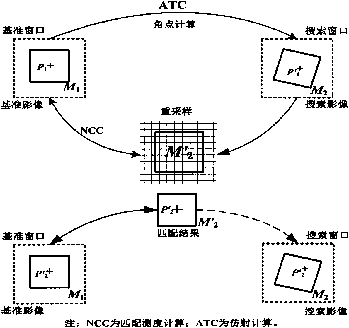
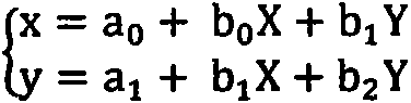
[0010] The high-precision matching method of low-altitude remote sensing images with consistent image space includes two core processes: initial image matching based on SURF features and precise image matching with geometric constraints. The two processes are described in detail below:

[0011] Based on the initial image matching of SURF features, the affine transformation relationship between the reference image and the search image is established. The SURF operator is a very well-known operator in the fields of computer vision and photogrammetry. It is widely used in many fields due to its anti-rotation and scale-invariant characteristics. Although SURF feature matching has the above-mentioned excellent characteristics, the algorithm itself ex...


PUM


Abstract

The invention discloses a low-altitude remote sensing image high-precision matching method with consistent image space. Firstly, SURF feature matching is carried out on the top layer of an image pyramid, and an affine transformation relation between a base image and a search image is built; then, feature point extraction is carried out on the base image, the affine transformation relation is used as a geometric constraint condition, a feature point window is switched to the search image, meanwhile, a window of the search image is corrected and re-sampled to be in an image space coordinate system of the base image, correlation coefficient matching is carried out, polynomial iteration is used for removing a gross error, obtained corresponding image points are utilized for resolving and updating the affine transformation relation between the base image and the search image again, and then the lower-layer image matching is carried out until bottom-layer image matching; finally, a matching result is converted to be under an image space coordinate system of the search image, and high-precision least squares matching is carried out. The method solves the problems that due to the fact that the problems of large rotating, geometry deformation and the like exist in the image space, the matching success rate is low, and a failure easily happens, and the matching efficiency and the success rate of a low-altitude image are greatly improved.

Description

technical field [0001] The invention relates to low-altitude remote sensing image matching, in particular to a low-altitude remote sensing image high-precision matching method with image square space consistency. Background technique [0002] In recent years, from UAV remote sensing used in topographic surveying and mapping of the Diaoyu Islands, to disaster remote sensing monitoring and disaster assessment in the Lushan earthquake in Sichuan, to the normal monitoring of national marine resources, low-altitude remote sensing technology has highlighted its role in topographic surveying and mapping, disaster emergency monitoring and disaster situation assessment. Low-altitude remote sensing data processing technology has quickly become a research hotspot due to its advantages and application value in many fields such as assessment and environmental monitoring. Image matching is one of the key technologies of low-altitude remote sensing data processing, and its matching quality...

Claims


Application Information

Patent Timeline
IPC IPC(8): G06T7/00
Inventor 倪金生钱晓明李传广
Owner BEIJING AEROSPACE TITAN TECH CO LTD
Why Eureka
Try Eureka