Rotation invariant submarine topography two-dimensional matching aided navigation method

A rotational invariance, assisted navigation technology, applied in navigation, mapping and navigation, navigation calculation tools, etc., can solve the problem of not considering the motion adaptation of the submersible vehicle, the richness of information and the weak adaptability of the algorithm.

Active Publication Date: 2014-11-19
SOUTHEAST UNIV
View PDF4 Cites 14 Cited by
  • Summary
  • Abstract
  • Description
  • Claims
  • Application Information

AI Technical Summary

Problems solved by technology

However, the above algorithms are either based on one-dimensional matching of single-beam sequences, which are weak in terms of information richness and algorithm adaptability; or they do not consider the motion adaptation problem of the submersible in various directions, that is, the anti-rotation matching problem

Method used


Image

  • Rotation invariant submarine topography two-dimensional matching aided navigation method
  • Rotation invariant submarine topography two-dimensional matching aided navigation method
  • Rotation invariant submarine topography two-dimensional matching aided navigation method

Examples


Embodiment Construction

[0059] The technical solutions of the present invention will be described in detail below, but the protection scope of the present invention is not limited to the embodiments.

[0060] The two-dimensional matching auxiliary navigation method of seabed terrain with rotation invariant characteristics of this embodiment is implemented in the following manner:

[0061] step 1:

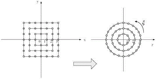
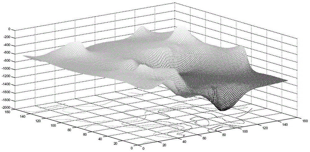
[0062] The real-time strip scanning depth value rectangular array is obtained from the multi-beam bathymetry system, and the background depth value matrix array is obtained from the original prior database according to the main inertial navigation error range. The simulation data is based on the seabed terrain elevation data of 127.528°-128.205° east longitude and 27.328°-28.005° north latitude in the national marine science database, interpolated to form a regular grid data matrix of 100×100m, the matrix size is 751×751, and the terrain is three-dimensional Figure such as figure 1 .

[0063] Convert ea...


PUM


Abstract

The invention discloses a rotation invariant submarine topography two-dimensional matching aided navigation method which comprises the following steps: 1) a real-time stripe sweeping survey depth value matrix array is obtained by a multi-beam sounding system, height array values are converted into gray values to obtain a template grayscale map; topography two-dimensional height array values in a region in the main navigation system error range are read, and then are converted into gray values to obtain a background grayscale map; 2) a rotation invariant image moment function is used as a characteristic feature, a region in the background grayscale map, matched with the characteristic feature of the template grayscale map can be searched, and the position of the multi-beam sounding system in real-time sweeping survey can be obtained. Compared with matching algorithms (such as TERCOM matching algorithm and SITAN matching algorithm) in the prior art which are performed by topography one-dimensional matching, the rotation invariant submarine topography two-dimensional matching aided navigation method overcomes the defects that the one-dimensional matching is low in accuracy and the restricted by topography, increases the richness of topography features description, and has higher accuracy and adaptability.

Description

technical field [0001] The invention relates to a two-dimensional matching auxiliary navigation method of seabed topography with rotation invariant characteristics, and belongs to the technical field of underwater auxiliary navigation. Background technique [0002] Research on terrain-aided navigation technology began more than 40 years ago, and the first application tests were carried out in the mid-1980s with a CV-580 equipment test aircraft. At present, a variety of terrain-aided navigation systems have been researched and developed at home and abroad, and several mature terrain-aided navigation systems have been equipped with weapons in actual combat and have been successfully tested. [0003] At present, the mature application of terrain-assisted navigation technology in foreign countries is still limited to aircraft and low-altitude aircraft navigation. With the widening of the application field of underwater submersibles, the demand for related technologies continues ...

Claims


Application Information

Patent Timeline
Patent Type & Authority Applications(China)
IPC IPC(8): G01C21/00G01C21/16G01C21/20
CPCG01C21/005G01C21/165G01C21/20
Inventor 徐晓苏岳增阳李佩娟张涛汤郡郡
Owner SOUTHEAST UNIV
Why Eureka
Try Eureka