Foundation cloud measuring method combining infrared and lasers

A laser and ground-based technology, applied in the field of ground-based cloud measurement, can solve the problems that cannot completely replace manual visual inspection, and achieve the effect of improving cloud detection effect and detection ability

Inactive Publication Date: 2014-12-03
PLA UNIV OF SCI & TECH
View PDF4 Cites 33 Cited by
  • Summary
  • Abstract
  • Description
  • Claims
  • Application Information

AI Technical Summary

Problems solved by technology

[0005] To sum up, the two technical systems that are most likely to realize the operationalization of cloud measurement, infrared passive remote s

Method used


Image

  • Foundation cloud measuring method combining infrared and lasers
  • Foundation cloud measuring method combining infrared and lasers
  • Foundation cloud measuring method combining infrared and lasers

Examples


Embodiment Construction

[0039] In order to make the purpose, technical solutions and advantages of the present invention clearer, the present invention will be described in further detail below in conjunction with specific embodiments and with reference to the accompanying drawings.

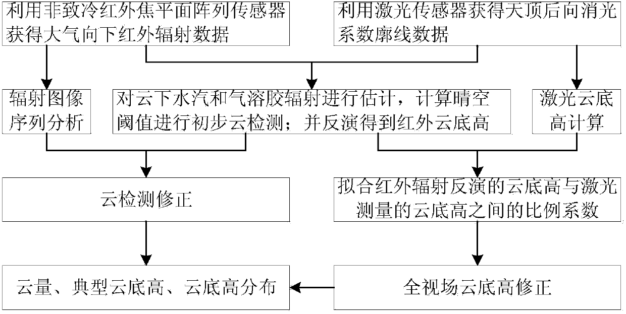
[0040] figure 1 It is a flow chart of the ground-based cloud survey method combined with infrared and laser proposed by the present invention, and the specific implementation of the method is as follows:

[0041] (1) Use the uncooled infrared focal plane array sensor to obtain the atmospheric downward infrared radiation data, and use the laser sensor to obtain the zenith backward extinction coefficient profile data. In this step, the key lies in the time synchronization of the acquired data, and the data acquisition system synchronizes the data acquisition every 1 minute and stores the data.

[0042] (2) Combine the above data to estimate the water vapor and aerosol radiation under the cloud, and use the clear sky thre...


PUM


Abstract

A foundation cloud measuring method combining infrared and lasers comprises the following steps that (1) atmosphere downward infrared radiation data are obtained through an uncooled infrared focal planar array sensor, zenith backward extinction coefficient profile data are obtained through a laser sensor, and the obtaining time of the atmosphere downward infrared radiation data is synchronous with the obtaining time of the zenith backward extinction coefficient profile data; (2) water vapor and aerosol radiation under cloud are estimated by combining the data, clear sky threshold values calculated through a radiation transmission pattern are used for conducting initial cloud detection, it is assumed that the cloud is a black body, and the cloud base height is obtained through inversion; (3) sequence analysis is conducted on infrared radiation images with high time resolution, the clear sky threshold values are combined to conduct further cloud detection, and the cloud cover is calculated; (4) proportionality coefficients between the cloud base height obtained through the infrared radiation inversion and the cloud base height obtained through laser measurement are fitted; (5) the cloud base height of a whole view field is corrected, and the typical cloud base heights of every ten minutes are obtained through calculation.

Description

technical field [0001] The invention relates to a ground-based cloud measurement method, in particular to a method for cloud detection and full-field cloud base height correction in combination with ground-based infrared and laser light, which is mainly used in automatic measurement of ground meteorological observation. Background technique [0002] Clouds usually cover about 50% of the Earth's atmosphere and are the main regulator of the radiation budget of the Earth-atmosphere system. Cloud observations have always been the basis for climate research, weather analysis and forecasting. For a long time, visual observation has been a commonly used method to estimate cloud amount and determine cloud height in meteorological operations. The description of the sky is also more difficult. At present, the main ground-based cloud measurement technology systems include visible light passive remote sensing system, infrared passive remote sensing system and laser active remote sensi...

Claims


Application Information

Patent Timeline
IPC IPC(8): G01W1/00G01S17/95G06F17/30
CPCY02A90/10
Inventor 刘磊高太长张婷赵世军韩文宇
Owner PLA UNIV OF SCI & TECH
Why Eureka
Try Eureka