
Method for rapidly collecting geographic information data in online collaboration mode in large field area

A technology of geographic information data and collection method, which is applied in the field of rapid field collection of online collaborative geographic information data in large areas, can solve the problems of slow update response to element changes, single inspection method, inability to achieve efficient storage, etc., to shorten the update cycle, the effect of improving collection efficiency

Inactive Publication Date: 2014-12-24
NAT GEOMATICS CENT OF CHINA
View PDF5 Cites 13 Cited by
  • Summary
  • Abstract
  • Description
  • Claims
  • Application Information

AI Technical Summary

Problems solved by technology

Due to the lack of unified dynamic scheduling management, it is impossible to accurately locate the changes of ground and object elements. Therefore, the task allocation and personnel scheduling of data production generally adopt the strategy of manual contracting in large areas, and each field working group undertakes a full set of internal and external operations. The process not only causes a lot of repetitive work, but also has a long operation cycle due to numerous procedures, and the update response to element changes is slow. It often takes several months from the assignment of tasks to the submission of results, which is time-consuming and labor-intensive and inefficient
[0004] 2. The collection operation units are scattered and isolated, and it is impossible to establish a collaborative operation and supervision and management mechanism
Temporary auxiliary materials needed by operators in the field cannot be obtained online, and the collected information cannot be quickly reflected in the database
Due to the limitation of online data transmission, it is actually impossible to form a collaborative operation mechanism, and it is also difficult to obtain the location and work progress of operators in real time, and it is impossible to quickly discover and collect large-scale geographical changes
[0005] 3. The quality inspection and review process of the results is complicated, and it is impossible to achieve efficient storage
Traditional data quality inspection mainly adopts the method of manual inspection, which is time-consuming and labor-intensive to manually check the location and attributes of elements against the collection results and original mapping pictures, operation base maps, etc.
Since the field collection content is limited to the location and text description information of the ground features, the corresponding inspection method is also relatively simple. Manual inspection needs to be combined with other data to judge the correctness. The requirements for quality inspection and review personnel are high, and the collection data cannot be realized Fast and efficient storage

Method used


Image

  • Method for rapidly collecting geographic information data in online collaboration mode in large field area

Examples


Embodiment Construction

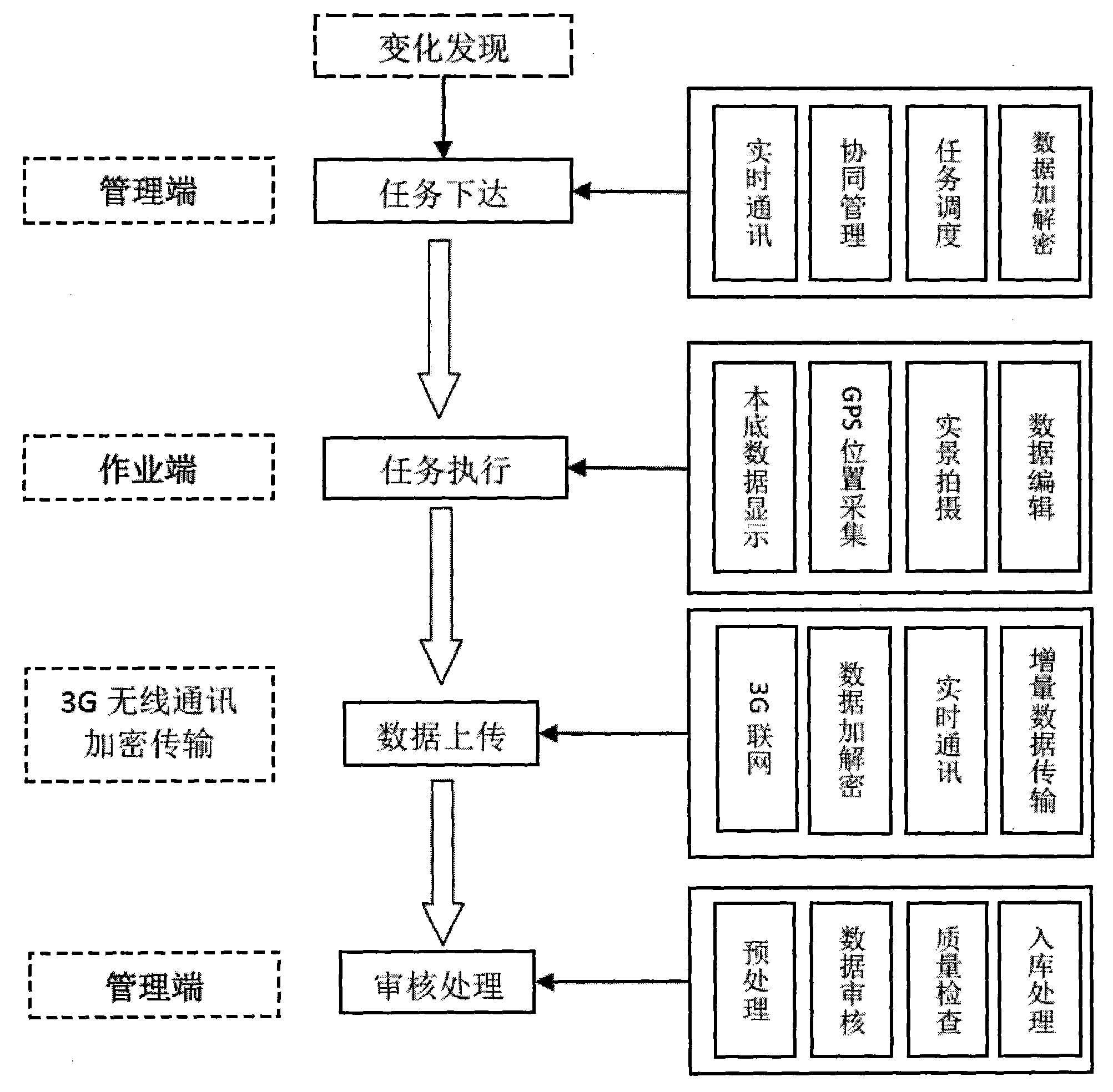
[0015] Such as figure 1 As shown, the online collaborative geographic information data field rapid collection method in a large area of ​​the present invention includes the following steps:

[0016] (1) Assignment of tasks: Monitoring and discovery of changes in landforms and geomorphology, combined with element update content and indicators, summarizing and sorting out an update task list, and transferring it to the field rapid collection system; the management end determines the latest update task through the task scheduling module Optimize the operation end, and then issue the update task to the corresponding operation end through the real-time communication module;

[0017] (2) Task execution: the operation terminal in the field receives corresponding update tasks through the real-time communication module, uses the GPS module to collect location information, uses the data editing module to collect attribute information, and uses the multimedia module to collect supporting...


PUM


Abstract

The invention provides a method for rapidly collecting geographic information data in an online collaboration mode in a large field area. The method meets the requirement for collecting information in a wide area and comprises the steps of (1) task assignment: carrying out monitoring to find the change of land features, updating content and indexes according to elements, carrying out summarization and arrangement to form a new task list and starting a rapid field collection system; (2) task execution; (3) data uploading; (4) check processing. The method for rapidly collecting the geographic information data in the online collaboration mode in the large field area has the advantages of integrated dispatching management, distributed collaborative operation, online data transmission, one-stop quality testing and library building and the like, thereby being capable of improving the geographic information data collection efficiency of various industries and sectors of China effectively, shortening the updating period of the geographic information data greatly and playing a positive role in rapid collection and updating of geographic information and rapid monitoring of geographical conditions.

Description

technical field [0001] The invention relates to a geographic information data collection method, in particular to a field rapid collection method of online collaborative geographic information data in a large area. Background technique [0002] At present, my country's geographic information data collection is mainly carried out through comprehensive judgment and adjustment, which generally includes technical processes such as internal industry preprocessing - field mapping - internal industry integration. This kind of production mode and technical method highlights the shortcomings of many production links and long update cycles, and it is difficult to meet the needs of rapid information collection or real-time update on demand. The main manifestations are: [0003] 1. Production scheduling in a large area is difficult, and precise positioning of tasks cannot be achieved. In the process of data collection in a large area, in order to ensure the progress of the entire proje...

Claims


Application Information

Patent Timeline
IPC IPC(8): G06Q10/06
Inventor 刘建军杜晓赵仁亮刘剑炜赵文豪
Owner NAT GEOMATICS CENT OF CHINA
Learn More