Method for simulating influence of urban green space patterns on thermal environments

A green space pattern and simulation method technology, applied in special data processing applications, instruments, electrical and digital data processing, etc., can solve the problems of lack of continuity and predictability of results, and achieve the effect of improving reliability and increasing predictive ability.

Inactive Publication Date: 2015-01-21
HOHAI UNIV
View PDF2 Cites 19 Cited by
  • Summary
  • Abstract
  • Description
  • Claims
  • Application Information

AI Technical Summary

Problems solved by technology

However, remote sensing images are instantaneous images, which can only obtain a specific temperature field on the surface at a certain moment, and the obtained results have no continuity and predictability.

Method used


Image

  • Method for simulating influence of urban green space patterns on thermal environments
  • Method for simulating influence of urban green space patterns on thermal environments
  • Method for simulating influence of urban green space patterns on thermal environments

Examples


Embodiment Construction

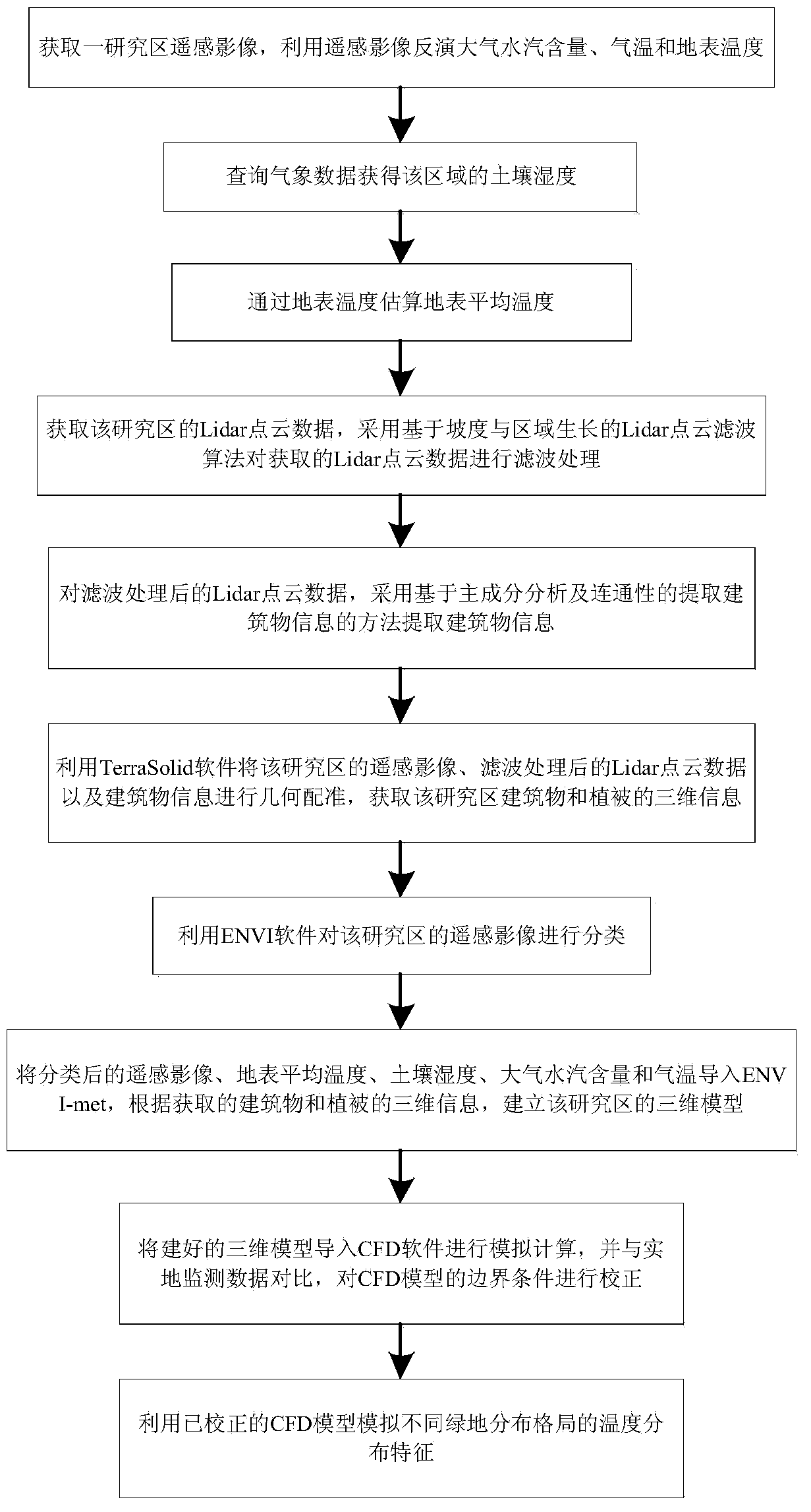
[0083] The present invention will be further described below in conjunction with the drawings. The following embodiments are only used to illustrate the technical solutions of the present invention more clearly, and cannot be used to limit the protection scope of the present invention.

[0084] Such as figure 1 As shown, a simulation method for the impact of urban green space on the thermal environment includes the following steps:

[0085] Step one is to obtain remote sensing images of a study area, and use remote sensing images to retrieve atmospheric water vapor content, air temperature and surface temperature.

[0086] The formula for retrieving atmospheric water vapor content is as follows,

[0087] w = ( α - ln ( ref 19 ref 2 ) β ) 2

[0088] Among them, w is the atmospheric water vapor content; α and β are constants, taking α = 0.02 and β = 0.651 respectively; ref2 and ref19 are the ground reflectivity of MODIS 2nd and 19th band...


PUM


Abstract

The invention discloses a method for simulating influence of urban green space patterns on thermal environments. The method comprises, firstly, extracting the surface feature distribution information of a researched region on remote sensing images through the object-oriented segmentation technology, filtering Lidar point cloud data to obtain three-dimensional information of buildings and vegetations, integrating the surface feature distribution information and the three-dimensional information of the buildings and vegetations to structure a high-precision three-dimensional model; secondly, inverting surface temperature, atmosphere moisture content and air temperature through the remote sensing technology to estimate surface average temperature, and querying meteorological data to obtain the soil moisture of the region, and taking the surface average temperature, the soil moisture, the atmosphere moisture content and the air temperature as the initial conditions of a CFD (computational fluid dynamics) model. By means of the high-precision three-dimensional model and by accurately simulating the initial conditions in real time, the method for simulating the influence of the urban green space patterns on the thermal environments improves the simulating precision and the application reliability of the CFD model; meanwhile, the CFD model enhances the prediction capacity of the remote sensing technology.

Description

Technical field [0001] The invention relates to a method for simulating the influence of urban green space pattern on thermal environment, in particular to a method for simulating the influence of urban green space on thermal environment based on remote sensing technology and CFD model. Background technique [0002] The “heat island” phenomenon is a phenomenon where the temperature in a certain local area (mainly urban area) is higher than the surrounding area. The intensity of the heat island can be expressed by the temperature difference between two representative measuring points, generally the temperature of a certain place in the city and the suburban area. The difference in temperature at the meteorological point. In recent decades, due to the rapid development of urbanization, changes in the underlying surface structure, and the influence of factors such as transportation heat and building heat, the urban thermal environment has gradually deteriorated, and the "heat island...

Claims


Application Information

Patent Timeline
Patent Type & Authority Applications(China)
IPC IPC(8): G06F17/50
Inventor 杨英宝章勇于双
Owner HOHAI UNIV
Why Eureka
Try Eureka