Peat bog information extracting method based on ENVISAT ASAR, Landsat TM and DEM data

A technology of information extraction and data, which is applied in the directions of instruments, character and pattern recognition, scene recognition, etc., can solve problems such as the difficulty in distinguishing peat bogs from other types of swamps, and achieve the effect of overcoming omission and misclassification

Active Publication Date: 2015-02-18
NORTHEAST INST OF GEOGRAPHY & AGRIECOLOGY C A S
View PDF6 Cites 27 Cited by
  • Summary
  • Abstract
  • Description
  • Claims
  • Application Information

AI Technical Summary

Problems solved by technology

[0007] The purpose of the present invention is to solve the problem that it is difficult to distinguish peat swamps from other swamp types using traditional

Method used


Image

  • Peat bog information extracting method based on ENVISAT ASAR, Landsat TM and DEM data
  • Peat bog information extracting method based on ENVISAT ASAR, Landsat TM and DEM data
  • Peat bog information extracting method based on ENVISAT ASAR, Landsat TM and DEM data

Examples


specific Embodiment approach 1

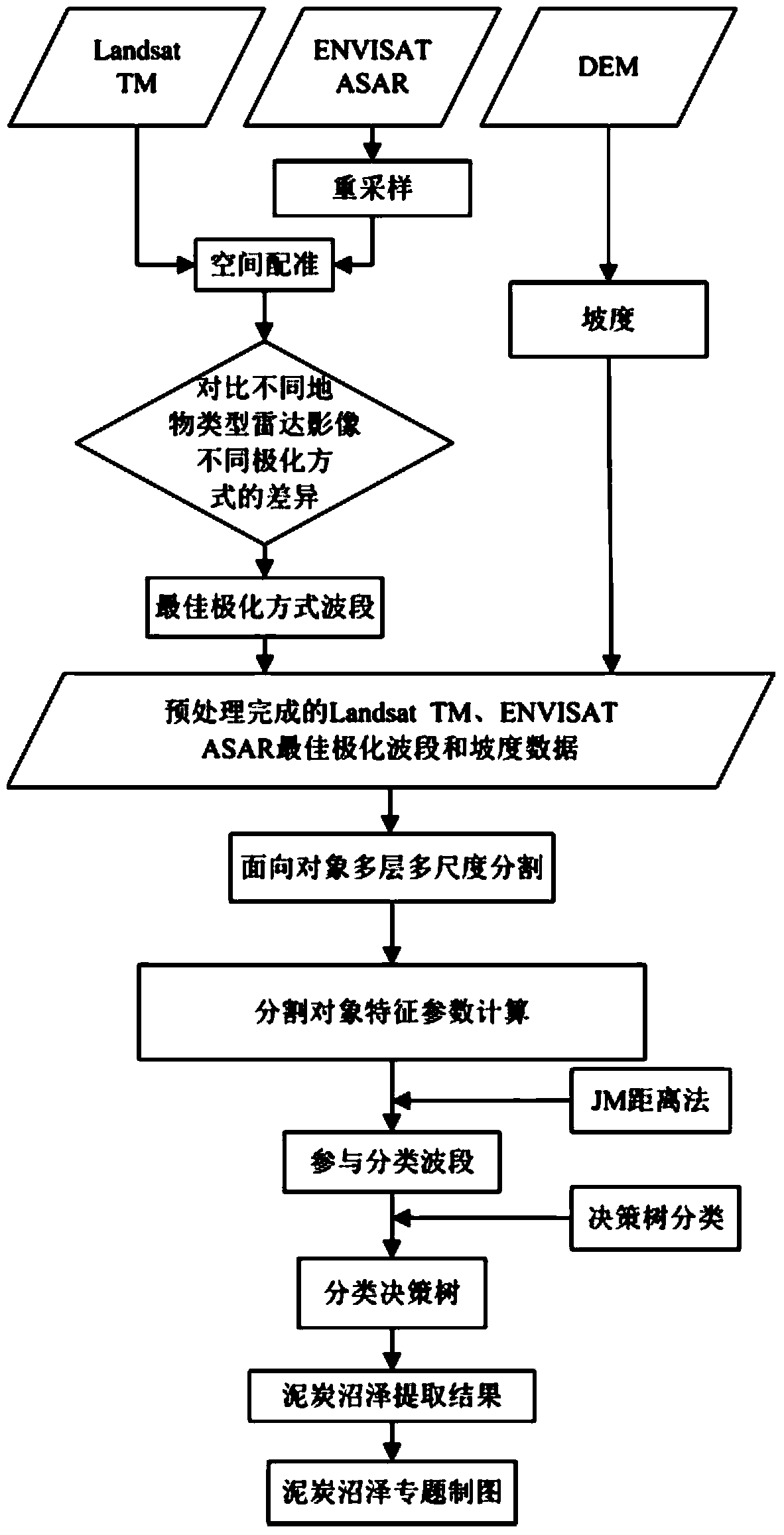
[0028] Embodiment 1: A peat swamp information extraction method based on ENVISAT ASAR, Landsat TM and DEM data in this embodiment is specifically prepared according to the following steps:

[0029] Step 1: Preprocessing the Landsat TM data;

[0030] Step 2: Preprocessing the ENVISAT ASAR data;

[0031] Step 3: Resample the ENVISAT ASAR data preprocessed in Step 2 in ArcGIS. The resampled ENVISAT ASAR data has the same grid size as the Landsat TM data processed in Step 1;

[0032] Step 4: Based on the preprocessed Landsat TM data, compare the preprocessed Landsat TM data and the resampled ENVISAT ASAR data in the ArcGIS software, and use the function of adding control points provided by the Georeferencing module of the ArcGIS software Select the control points on the preprocessed Landsat TM data, and register the resampled ENVISAT ASAR data according to the control point space to obtain the ENVISAT ASAR image;

[0033] Step 5: Use the Aspect command in Surface Analysis under ...

specific Embodiment approach 2

[0046] Specific embodiment two: the difference between this embodiment and specific embodiment one is: the preprocessing process is carried out to Landsat TM data in step one:

[0047] (1) Within the distribution range of the peat bog, determine the track number of the Landsat TM data of the peat bog, and download the Landsat TM data covering the distribution range of the peat bog according to the track number;

[0048] (2) In order to eliminate terrain distortion, the Landsat TM data is orthorectified by using the DEM data of the corresponding area of ​​the Landsat TM data to obtain the Landsat TM data after orthorectification;

[0049] (3) In order to eliminate geometric distortion, use terrain data, select ground control points in ERDAS software, and perform geometric fine correction on Landsat TM data after orthorectification to obtain preprocessed Landsat TM data. Other steps and parameters are the same as those in Embodiment 1.

specific Embodiment approach 3

[0050] Specific implementation mode three: the difference between this implementation mode and specific implementation mode one or two is: in step 2, ENVISAT ASAR data is carried out preprocessing process:

[0051] (1) Within the coverage of the Landsat TM data range, download the ENVISAT ASAR fine image first-level data (ENVISAT ASAR APP Level 1B data) used in the test (the polarization mode is HH and HV);

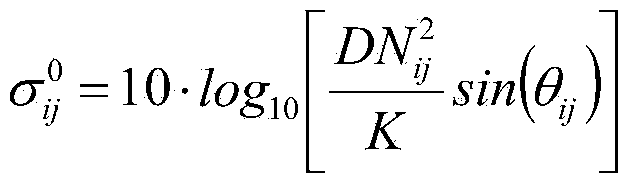
[0052] (2) Carry out radiometric calibration on ENVISAT ASAR fine image first-level data, that is, convert the DN value of ENVISAT ASAR fine image first-level data into backscatter coefficient (in dB), and obtain radiation-corrected ENVISAT ASAR data; its radiometric calibration The formula is as follows:

[0053] σ ij 0 = 10 · log 10 [ DN ij 2 K sin ...


PUM


Abstract

The invention relates to peat bog information extracting methods, in particular to a peat bog information extracting method based on ENVISAT ASAR, Landsat TM and DEM data, and solves the problem that peat bog and other bog types cannot be distinguished by a conventional method. The peat bog information extracting method includes step 1, preprocessing Landsat TM data; step 2, preprocessing ENVISAT ASAR data; step 3, re-sampling the ENVISAT ASAR data; step 4, acquiring an ENVISAT ASAR image; step 5, acquiring gradient data; step 6, extracting back scattering coefficient; step 7, determining optimal polarization mode waveband of the ENVISAT ASAR image; step 8, acquiring a division unit; step 9, extracting feature parameters; step 10, determining optimal classification waveband; step 11, establishing a classification decision-making tree; step 12, generating a soil covering type vector file; step 13, making a peat bog map. The peat bog information extracting method is applied to the field of peat bog information extracting.

Description

technical field [0001] The invention relates to an information extraction method, in particular to a peat swamp information extraction method. Background technique [0002] Peat swamp is one of the main types of wetlands, which plays an important role in maintaining regional ecological balance and sustainable development. In addition, due to the huge carbon storage in peat swamps, accounting for about 1 / 3 of the global terrestrial carbon pool, equivalent to 75% of the carbon content in the atmosphere, peat swamps play a pivotal role in global climate change and ecosystem balance status. In recent years, experts and scholars at home and abroad have used different remote sensing image data to study the spatial information extraction of wetland types such as herbaceous wetlands, forest wetlands, and coastal mangrove wetlands. Relatively small. [0003] Optical remote sensing data has the advantages and characteristics of rich spectral information, high cost performance, easy...

Claims


Application Information

Patent Timeline
IPC IPC(8): G06K9/46
CPCG06V20/13
Inventor 路春燕王宗明毛德华
Owner NORTHEAST INST OF GEOGRAPHY & AGRIECOLOGY C A S
Why Eureka
Try Eureka