Intelligent comprehensive geologic survey instrument for mine and measuring method of intelligent comprehensive geologic survey instrument

A measuring method and measuring instrument technology, applied in measuring devices, line-of-sight measurement, measuring distance, etc., to achieve the effects of improving measurement accuracy, avoiding magnetic field interference, and convenient operation

Active Publication Date: 2015-03-11
ANHUI HUIZHOU GEOLOGY SECURITY INST
View PDF6 Cites 6 Cited by
  • Summary
  • Abstract
  • Description
  • Claims
  • Application Information

AI Technical Summary

Problems solved by technology

[0005] The purpose of the present invention is to solve the defect that there is no comprehensive geological survey instrument used in underground complex conditions in the prior art, and provide a mine intelligent comprehensive geological survey instrument and its measurement method to solve the above problems

Method used


Image

  • Intelligent comprehensive geologic survey instrument for mine and measuring method of intelligent comprehensive geologic survey instrument
  • Intelligent comprehensive geologic survey instrument for mine and measuring method of intelligent comprehensive geologic survey instrument
  • Intelligent comprehensive geologic survey instrument for mine and measuring method of intelligent comprehensive geologic survey instrument

Examples


Embodiment Construction

[0044] In order to have a further understanding and understanding of the structural features of the present invention and the achieved effects, the preferred embodiments and accompanying drawings are used for a detailed description, as follows:

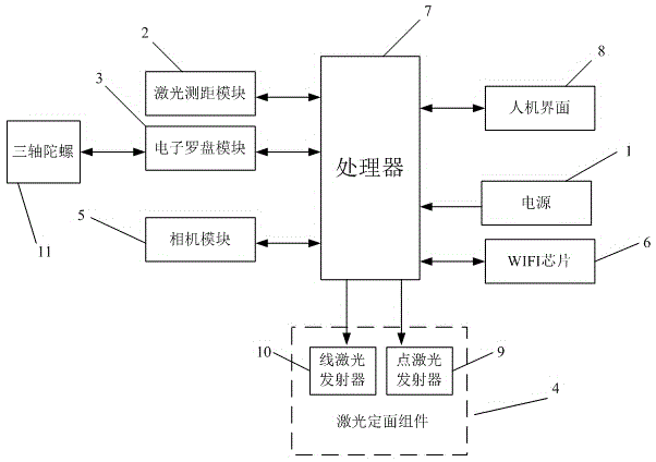
[0045] Such as figure 1 As shown, a mine intelligent comprehensive geological surveying instrument according to the present invention includes a laser ranging module 2, an electronic compass module 3, a laser plane fixing component 4 and a processor 7, and a power supply 1 is connected to the processor 7 for giving The entire instrument is powered. Laser ranging module 2 is used to provide distance measurement function; electronic compass module 3 is used to provide tilt angle, azimuth angle and roll angle measurement function. In order to avoid magnetic field interference, the design mode of three-axis gyro can also be added, three-axis gyro 11 and The electronic compass modules 3 are connected through serial ports. When in use, st...


PUM


Abstract

The invention relates to an intelligent comprehensive geologic survey instrument for a mine and a measuring method of the intelligent comprehensive geologic survey instrument and overcomes the defect that the comprehensive geologic survey instrument is still not produced for complicated underground conditions in the prior art. The intelligent comprehensive geologic survey instrument comprises a laser ranging module, an electronic compass module, a laser surface-fixing component and a processor, wherein the laser ranging module and the electronic compass module are respectively connected with serial ports of the processor; the laser surface-fixing component is connected with a control terminal of the processor; the mounting positions of the electronic compass module and the laser surface-fixing component are located on the same horizontal plane. The intelligent comprehensive geologic survey instrument disclosed by the invention integrates multiple functions; the multiple functions are mutually coordinated to improve the accuracy and the measuring efficiency of underground measurement; the operation is more convenient.

Description

technical field [0001] The invention relates to the technical field of mine geological surveying, in particular to an intelligent comprehensive geological surveying instrument for mines and a measuring method thereof. Background technique [0002] Mine geological survey work is an important technical basis for coal mine production and construction. All mining work and safe production in mines must be based on reliable geological data. Geological survey work generally relies on the three major geological components (compass, tape measure, hammer), plus record books and pens to complete the survey. [0003] Traditionally, there are two main methods for measuring the occurrence: the direct measurement method with a geological compass and the indirect measurement method using a gradient gauge (semicircle) to level the ground. 1. When the geological compass direct measurement method is used to measure the occurrence of coal, rock formations, faults, etc., due to the interference...

Claims


Application Information

Patent Timeline
Patent Type & Authority Applications(China)
IPC IPC(8): G01C3/00G01C5/00G01C1/00G01C9/00G01C17/32
CPCG01C1/00G01C3/00G01C5/00G01C9/00G01C17/32
Inventor 倪圣军王宗涛胡斌叶安宏李雪峰陈兴海桑慧亭吴记军
Owner ANHUI HUIZHOU GEOLOGY SECURITY INST
Why Eureka
Try Eureka