Remote sensing image airport detection method based on weak supervised learning frame

A remote sensing image and weak supervision technology, applied in image analysis, image data processing, scene recognition, etc., can solve the time-consuming and labor-intensive problems of manual labeling, and achieve the effect of reducing the workload of labeling

Active Publication Date: 2015-03-25
NORTHWESTERN POLYTECHNICAL UNIV
View PDF4 Cites 18 Cited by
  • Summary
  • Abstract
  • Description
  • Claims
  • Application Information

AI Technical Summary

Problems solved by technology

[0006] In order to avoid the deficiencies of the prior art, the present invention proposes a remote sensing image airport detection method based on a weakly supervised learning framework to solve the time-consuming and labor-intensive problem of manual labeling

Method used


Image

  • Remote sensing image airport detection method based on weak supervised learning frame
  • Remote sensing image airport detection method based on weak supervised learning frame
  • Remote sensing image airport detection method based on weak supervised learning frame

Examples


Embodiment Construction

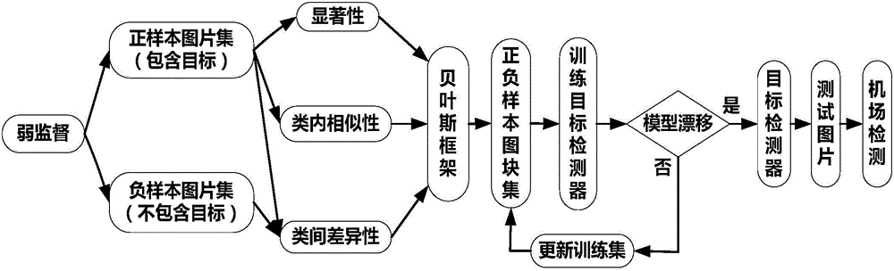
[0031] Now in conjunction with embodiment, accompanying drawing, the present invention will be further described:

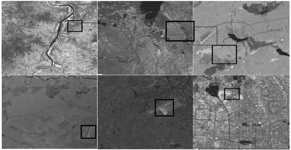
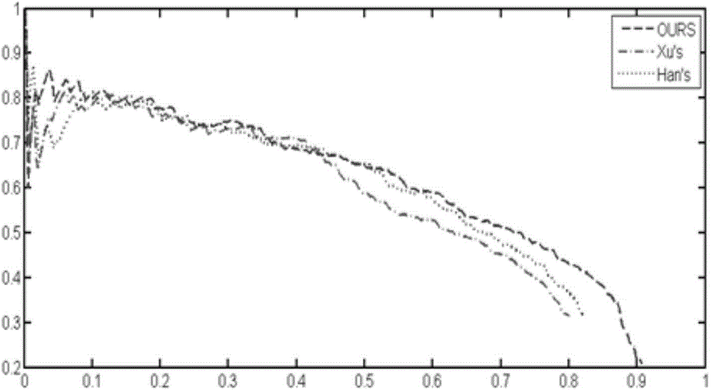
[0032] The hardware environment used for implementation is: Intel Pentium 2.93GHz CPU computer, 2.0GB memory, the software environment of operation is: Matlab R2011b and Windows XP. All the images in the Landsat database were selected as the test data in the experiment. The database contains 180 short-wave-infrared remote sensing images, and it is an internationally public database used to test the calculation model of airport detection in remote sensing images.

[0033] The present invention is specifically implemented as follows:

[0034] 1. Classify the positive and negative samples of multiple remote sensing images randomly selected in the remote sensing image database, and use the remote sensing images containing airport information as positive sample images, and the remote sensing images without airport information as negative sample images;

[0035] 2. Us...


PUM


Abstract

The invention relates to a remote sensing image airport detection method based on a weak supervised learning frame. The method comprises the steps that firstly, the saliency of image blocks in a positive sample, the similarity of image blocks in a positive sample set and the inter-class difference between the positive sample and a negative sample are obtained, then, the Bayesian frame is utilized for fusing the three classes of information to obtain an initial positive and negative training set, then, iteration training of the training set is utilized for obtaining a final stable airport detector, the airport detector is used for detecting an airport of a tested image, and finally the airport detection result with better accuracy and robustness is obtained.

Description

technical field [0001] The invention belongs to the field of computer vision algorithm research, and relates to a remote sensing image airport detection method based on a weakly supervised learning framework, which can accurately and robustly detect an image airport in a remote sensing image database. Background technique [0002] The rapid development of remote sensing technology has enabled many satellite and aerial sensors to provide optical images with high spatial resolution, which have a wide range of applications, such as disaster management, land planning, surveillance and traffic planning. Among these applications, automatic detection of natural or man-made objects is a fundamental task and has attracted increasing research interest. The rich spatial information and detailed structural information contained in optical remote sensing images of airports provide us with new opportunities to solve this challenging task. [0003] The early detection of airports in remot...

Claims


Application Information

Patent Timeline
Patent Type & Authority Applications(China)
IPC IPC(8): G06K9/66G06T7/00
CPCG06V20/13G06V10/462G06F18/243
Inventor 韩军伟张鼎文李超郭雷
Owner NORTHWESTERN POLYTECHNICAL UNIV
Why Eureka
Try Eureka