System and method for positioning agricultural machinery based on satellite navigation and dead reckoning

A technology for agricultural machinery and satellite navigation, applied in the fields of navigation and positioning and agricultural machinery positioning, which can solve the problems of GPS implementation of accumulated errors of DR algorithms.

Inactive Publication Date: 2015-04-08
SHANGHAI HUACE NAVIGATION TECH
View PDF4 Cites 15 Cited by
  • Summary
  • Abstract
  • Description
  • Claims
  • Application Information

AI Technical Summary

Problems solved by technology

[0008] The purpose of the present invention is to overcome the shortcoming of above-mentioned prior art, provide a kind of real-time property that can realize combining DR algorithm and the high advantage of GPS precision, overco

Method used


Image

  • System and method for positioning agricultural machinery based on satellite navigation and dead reckoning
  • System and method for positioning agricultural machinery based on satellite navigation and dead reckoning
  • System and method for positioning agricultural machinery based on satellite navigation and dead reckoning

Examples


Embodiment Construction

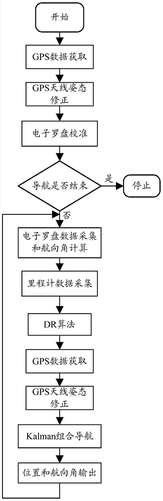
[0067] In order to describe the technical content of the present invention more clearly, further description will be given below in conjunction with specific embodiments.

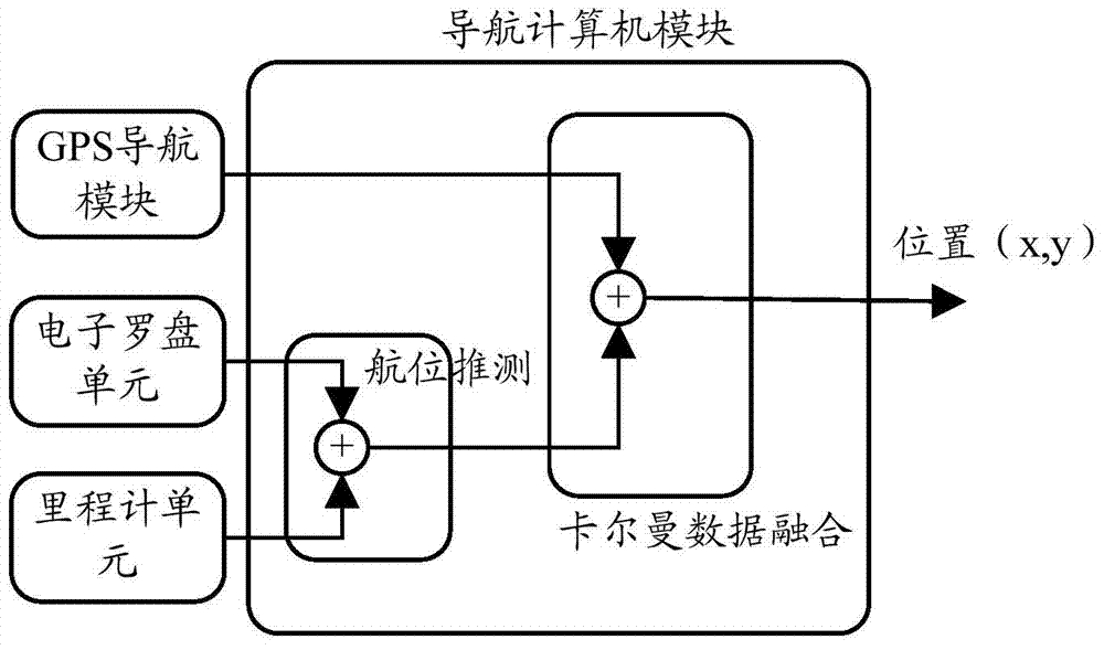
[0068] Aiming at the defects of low GPS data output frequency, discontinuity and integration error in the DR algorithm of the IMU sensor in the acquisition of the position information of the agricultural machinery auxiliary driving control system, the present invention designs a navigation positioning algorithm using technologies such as odometer and integrated navigation .

[0069] The main feature of the system for realizing agricultural machinery positioning based on satellite navigation and dead reckoning is that the system includes:

[0070] A satellite navigation module, used to obtain the geographic location information of the agricultural machinery;

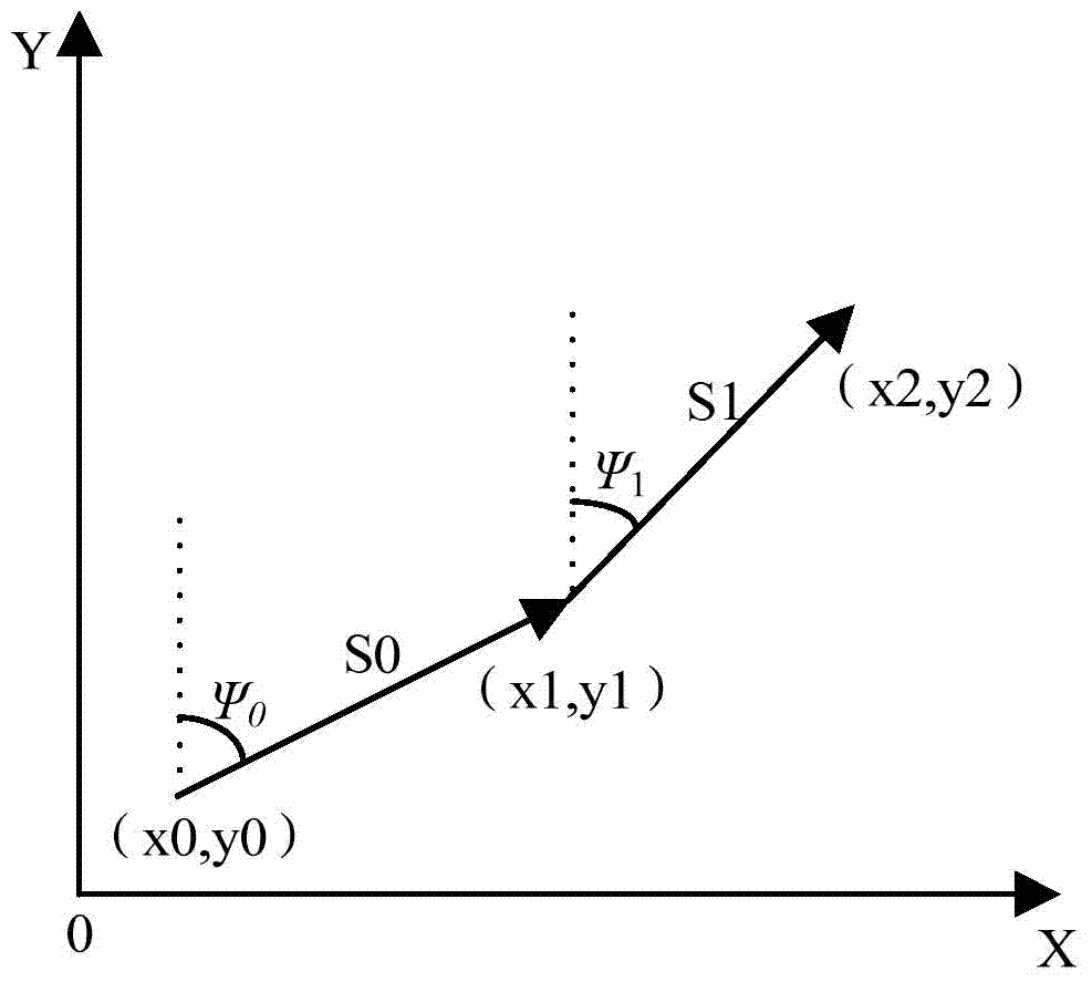
[0071] A dead reckoning module, used to collect the relative movement displacement and heading angle of the agricultural machinery for dead reckoning...


PUM


Abstract

The invention relates to a system and a method for positioning agricultural machinery based on satellite navigation and dead reckoning, wherein the system comprises a satellite navigation module, a dead reckoning module, and a navigation computer module; the satellite navigation module is used for obtaining geographical location information of the agricultural machinery; the dead reckoning module is used for collecting a relative displacement and a course angle of the agricultural machinery for implementing the dead reckoning calculation; the navigation computer module is used for employing the Kalman data fusion algorithm in combination with the satellite navigation module and the navigation computer module for positioning the agricultural machinery. The method and system for positioning agricultural machinery based on satellite navigation and dead reckoning employing such a structure achieves the advantage incorporating the instantaneity of the DR algorithm with the high precision of GPS, overcomes the defects of accumulative error of the DR algorithm and the bad implementation of GPS; the system and method have a higher precision and instantaneity, and are specifically applicable to obtaining and processing data in agricultural machinery auxiliary driving control system; the system and method have a wider application range.

Description

technical field [0001] The present invention relates to the technical field of navigation and positioning, in particular to the technical field of agricultural machinery positioning, and specifically refers to a system and method for realizing agricultural machinery positioning based on satellite navigation and dead reckoning. Background technique [0002] With the development of sensors and control technology and the further increase of the country's support for agriculture, precision agriculture is rapidly becoming a trend. In the process of auxiliary driving control of agricultural machinery, the heading angle and position information of the vehicle body are required by the control algorithm. two important factors. Currently, in the navigation and positioning system, there are two widely used navigation methods: GPS (Global Positioning System, Global Positioning System) and DR (Dead Reckoning, Dead Reckoning). [0003] GPS is global, all-weather, high-precision, and prov...

Claims


Application Information

Patent Timeline
IPC IPC(8): G01S19/49G01C21/16
CPCG01S19/49G01C21/165
Inventor 任强王杰俊沈雪峰戴文鼎
Owner SHANGHAI HUACE NAVIGATION TECH
Why Eureka
Try Eureka