GPS simulation method and system based on positioning and time service of Beidou satellite

A Beidou satellite and Beidou timing technology, applied in the field of satellite navigation, can solve problems such as direct replacement of GPS receivers, achieve the effects of improving safety and reliability, reducing the difficulty of replacement, and realizing time synchronization

Active Publication Date: 2015-04-29
SHENZHEN TOJOIN COMM TECH
View PDF5 Cites 35 Cited by
  • Summary
  • Abstract
  • Description
  • Claims
  • Application Information

AI Technical Summary

Problems solved by technology

[0004] What the present invention aims to solve is the problem that the GPS receiver in the base station cannot be directly replaced with a BD timing receiver because the GPS receiver in the base station is coupled with other equipment in the base station. GPS Simulation Method and System for Synchronization and Timing

Method used


Image

  • GPS simulation method and system based on positioning and time service of Beidou satellite
  • GPS simulation method and system based on positioning and time service of Beidou satellite
  • GPS simulation method and system based on positioning and time service of Beidou satellite

Examples


Embodiment Construction

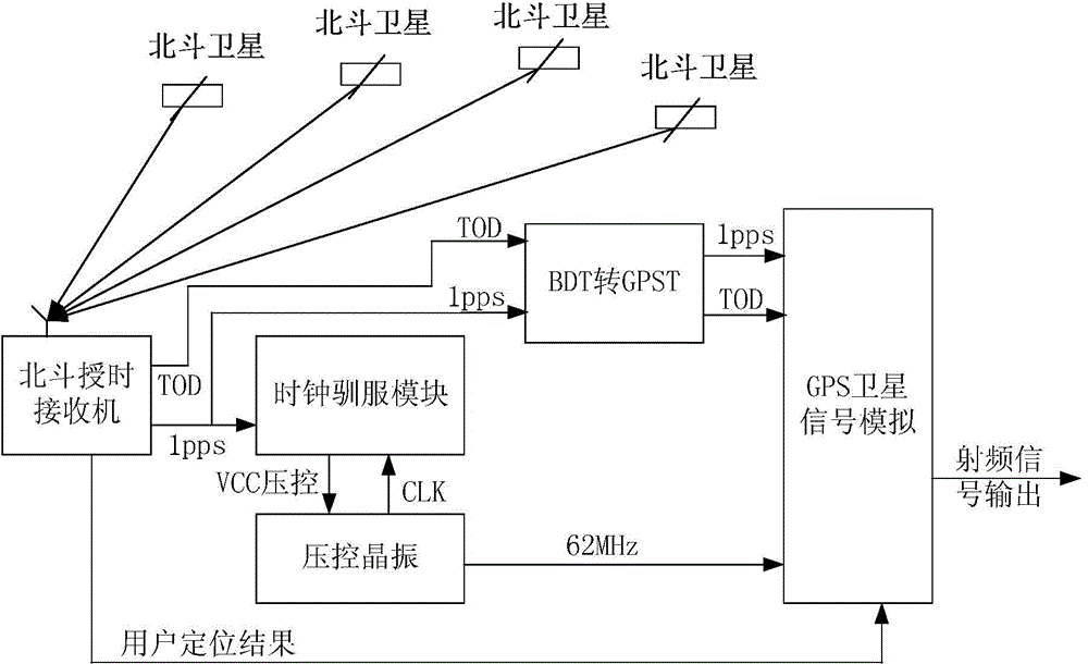
[0024] A GPS simulation method based on Beidou satellite positioning and timing service, comprising the steps of:

[0025] Step 1. The Beidou timing receiver receives the Beidou satellite navigation signal, obtains timing information and positioning information through signal down-conversion, DA conversion, despreading, decoding, time extraction, etc., and outputs information such as pps second pulse, TOD and position.

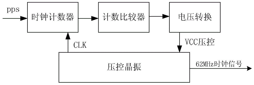
[0026] Step 2, use the timing information obtained in step 1 to tame the local clock, that is, the local crystal oscillator, to realize the time synchronization between the voltage-controlled crystal oscillator and the Beidou system.

[0027] Step 3, using the timing information obtained in step 1 and the time parameters in the Beidou ephemeris to convert Beidou time into GPS time, and synchronously generate GPS analog signals.

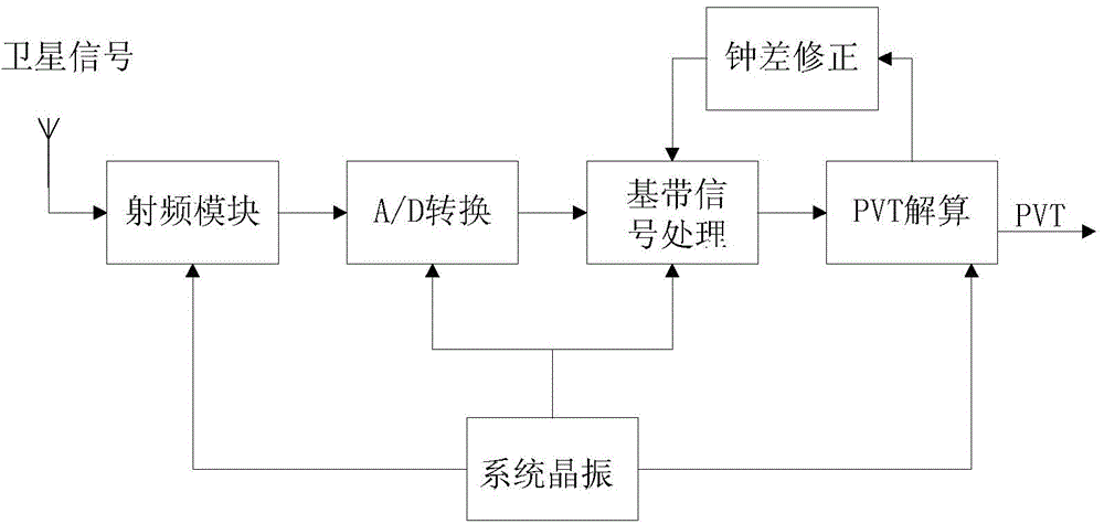
[0028] Step 4, under the control of the local clock obtained in step 2, use the positioning information obtained in step 1 and the G...


PUM


Abstract

The invention discloses a GPS simulation method and system based on positioning and time service of a Beidou satellite. The GPS simulation system is additionally arranged at the front end of a GPS receiver of an existing base station, a time service result of a Beidou time service receiver is used for taming a local voltage controlled oscillator, and therefore the time of the local voltage controlled oscillator and the time of a Beidou system are synchronous. Under the action of the local voltage controlled oscillator, by using the positioning result and ephemeris parameters of the Beidou time service receiver, GPS simulation signals are synchronously generated for the GPS receiver to complete positioning and time service. In this way, conversion from GPS time service to Beidou time service can be achieved without replacing all devices (including the GPS receiver) in the base station, and therefore the difficulty of replacing the time service conversion devices can be greatly lowered. In addition, the base station after the devices are replaced does not need to depend on an existing GPS system controlled by the USA and uses a Beidou system with the proprietary intellectual property right of China instead, and then the safety and the reliability of communication are effectively promoted.

Description

technical field [0001] The invention relates to the technical field of satellite navigation, in particular to a GPS simulation method and system based on Beidou satellite positioning and timing. Background technique [0002] China Telecom's CDMA system covers a wide area, and strict time synchronization is required between base stations, otherwise, call switching will fail, or even call establishment will not be possible. At present, the time synchronization in each base station adopts GPS timing. On the afternoon of January 13, 2011, the GPS system was upgraded, causing a network alarm phenomenon in China Telecom's CDMA. GPS is the satellite navigation system of the United States, developed and controlled by the U.S. military. Its system can perform local performance degradation settings and limit its use at any time. Once the GPS fails, the switching error rate and call drop rate of the CDMA network will increase significantly. If the network system is paralyzed, it will...

Claims


Application Information

Patent Timeline
Patent Type & Authority Applications(China)
IPC IPC(8): G01S19/36G01S19/33G04R20/02G04R20/04
CPCG01S19/33G01S19/36G04R20/04
Inventor 孙希延纪元法欧阳缮廖桂生符强孙希刚
Owner SHENZHEN TOJOIN COMM TECH
Why Eureka
Try Eureka