High-precision map generation system and method based on high-definition ortho-photo map

A technology for generating orthophoto maps and maps, applied in the field of map surveying and mapping, can solve problems such as difficult to reach centimeter-level data accuracy, limited data types, and large data volume, and achieve small occlusion data volume, low overall cost, and high resolution Effect

Active Publication Date: 2015-04-29
SHANGHAI JIAO TONG UNIV
View PDF3 Cites 85 Cited by
  • Summary
  • Abstract
  • Description
  • Claims
  • Application Information

AI Technical Summary

Problems solved by technology

[0004] At present, there are other methods for making high-definition maps, such as using lidar. Lidar collects information with high accuracy and good globality, but the cost is high, the amount of data is large, and the generated image is a reflectance image, which is different from the real scene. The image method is cheap and easy to use
[0005] The Chinese patent

Method used


Image

  • High-precision map generation system and method based on high-definition ortho-photo map
  • High-precision map generation system and method based on high-definition ortho-photo map
  • High-precision map generation system and method based on high-definition ortho-photo map

Examples


Embodiment Construction

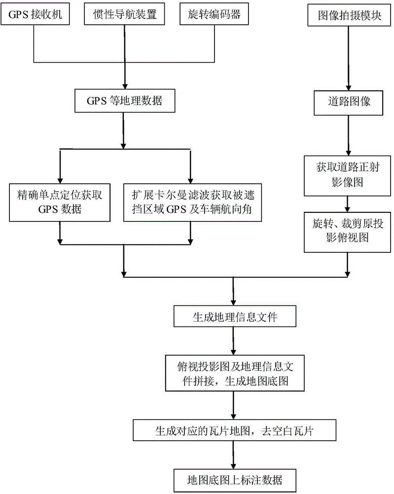
[0039] The present invention will be described in detail below in conjunction with specific embodiments. The following examples will help those skilled in the art to further understand the present invention, but do not limit the present invention in any form. It should be noted that those skilled in the art can make several modifications and improvements without departing from the concept of the present invention. These all belong to the protection scope of the present invention.

[0040] Such as figure 2 As shown, this embodiment provides a high-definition map generation system based on high-definition orthophoto maps, including:

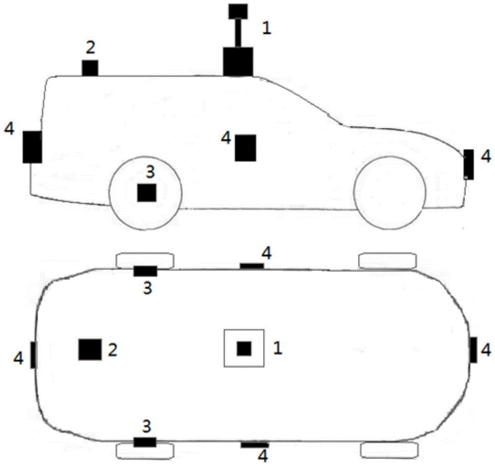
[0041] The image capture module collects road images from various angles around the vehicle at the same location, and obtains a high-resolution orthographic projection image of the road through an image processing algorithm. The orthographic projection image will be used as the input of the image and data preprocessing module to generate geographi...


PUM


Abstract

The invention provides a high-precision map generation system and a high-precision map generation method based on a high-definition ortho-photo map. The system comprises an image shooting module, a horizontal laser radar, a GPS (global positioning system) processing module, an inertial navigation module, a rotary encoder, an image and data preprocessing module and a geographical information processing module, wherein the vehicle-mounted image shooting module is used for acquiring a road image; the laser radar is used for scanning a barrier and acquiring geographical information data; the precision of GPS information is optimized; the ortho-photo map of the road image is acquired and then is rotated and sheared to generate corresponding geographical information file operation; a full ortho-photo map sequence and a corresponding geographical information file are combined and spliced to generate a base map of a global map; various types of geographical information data are marked on the base map of the map. According to the method and the system, a high-precision navigation map can be generated, and the data precision can reach centimeter level; the method and the system are extremely high in practical value on an advanced auxiliary driving system and an unmanned vehicle.

Description

technical field [0001] The present invention relates to the field of map surveying and mapping, in particular to a system and method for generating a high-definition map based on a high-definition orthophoto map. Background technique [0002] Maps have become an integral part of the daily travel of vehicles, mainly used for environment viewing and route navigation. However, at present, most common maps can only provide geographic information with road-level accuracy. Drivers or driving systems cannot know the current road lane information and which lane they are in from the map, and the road-related information contained in these maps is limited. It only contains the approximate location information and road shape information of part of the traffic sign information, which has low precision and small amount of information, and cannot fully reflect the characteristics of the road. Common map images use satellite images or aerial images. The image resolution is low, most of wh...

Claims


Application Information

Patent Timeline
IPC IPC(8): G06K9/64G06K9/20G09B29/00
CPCG09B29/005G09B29/006
Inventor 杨明路昊王春香王冰
Owner SHANGHAI JIAO TONG UNIV
Why Eureka
Try Eureka