Spatial gesture interactive type maritime silk road dynamic history GIS and implementation method

An interactive and gestic technology, applied in user/computer interaction input/output, mechanical mode conversion, instruments, etc., can solve the problems of reduced user operation experience, inconvenient operation, poor dynamic performance, etc., and achieve dynamic display performance. Good, easy to operate, good dynamic performance

Inactive Publication Date: 2015-06-24
GUANGDONG UNIV OF TECH
View PDF5 Cites 3 Cited by
  • Summary
  • Abstract
  • Description
  • Claims
  • Application Information

AI Technical Summary

Problems solved by technology

However, most of the current Maritime Silk Road display technologies need to manually press the mouse or manually touch the display screen to display the desired content for the viewer. The operation is not convenient enough, and the display is prone to delay due to non-real-time data collection. , the dynamic performance is poor, which reduces the user's operating experience

Method used


Image

  • Spatial gesture interactive type maritime silk road dynamic history GIS and implementation method
  • Spatial gesture interactive type maritime silk road dynamic history GIS and implementation method
  • Spatial gesture interactive type maritime silk road dynamic history GIS and implementation method

Examples


no. 1 example

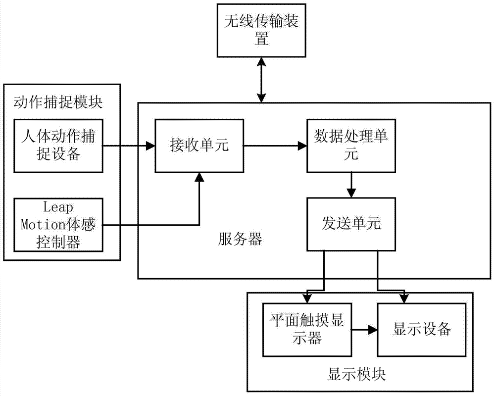
[0089] The GIS system of the present invention performs spatial gesture interaction in the space of the GIS platform, and has the following components: a flat touch display, a display device, a human motion capture device, a server, a wireless transmission device, and a Leap Motion somatosensory control device.

[0090] Wherein, the flat touch display is used to display the dynamic historical GIS and interactive interface of the Maritime Silk Road. During specific implementation, the flat touch display is used for displaying interactive interfaces and video information, and can also be used for activating display devices for real-time interactive display, and for connecting mobile display devices for real-time interaction.

[0091] The display device uses the light wave interference method to simultaneously record the amplitude and phase of the object light wave. The re-appearance light wave retains all the amplitude and phase information of the original object light wave, so...

no. 2 example

[0099] The concrete implementation method of the present invention is as follows:

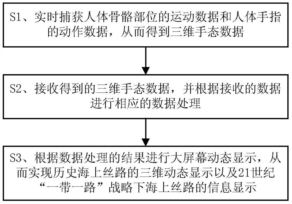
[0100] a. After the user expresses the gesture information in the space, the human body motion capture device and the Leap Motion somatosensory controller capture the movement of the human hand joints in three dimensions and convert them into corresponding data information.

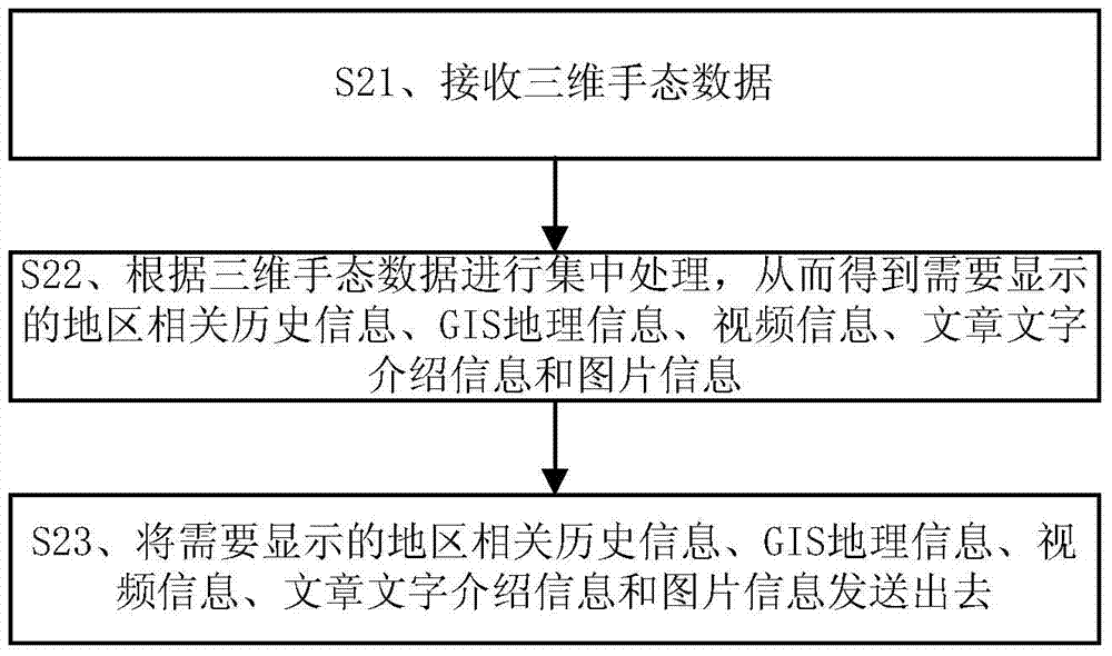
[0101] b. Compile and deploy the code through the back-end server of the GIS platform, and receive the 3D hand gesture data obtained by the human motion capture device in real time.

[0102] c. Dynamically call the layer algorithm for compilation and deployment, and call its layer data according to the logic of the comprehensive information of resource equipment;

[0103] d. Realize the operation of spatial gesture interaction, the operation process is further divided into:

[0104] (1) Designate the operating language of the GIS platform according to the different expression characteristics of the shape and spatial relat...


PUM


Abstract

The invention discloses a spatial gesture interactive type maritime silk road dynamic history GIS and an implementation method. The GIS comprises a motion capturing module for capturing motion data of human bones and motion data of human fingers in real time to obtain three-dimensional gesture data, a server for receiving the obtained three-dimensional gesture data and correspondingly processing the received data, and a display module for dynamically displaying a data processing result on a large screen so that historical maritime silk road three-dimensional dynamic display and maritime silk road information display under a 21-century 'one belt and one road' strategy can be achieved. By means of a spatial gesture interactive non-contact mode, operation is quite convenient; the motion capturing module captures real-time gesture three-dimensional data, the dynamic display performance is good, and the operation experience of a user is improved. The GIS can be widely applied to the display field.

Description

technical field [0001] The invention relates to the field of display, in particular to a spatial gesture interactive Maritime Silk Road dynamic history GIS system and an implementation method. Background technique [0002] GIS is the English abbreviation of Geographic Information System. GIS is a specific and very important spatial information system. With the support of computer hardware and software systems, it collects, stores, manages, calculates, analyzes, displays and describes the relevant geographical distribution data in the space of the entire or part of the earth's surface (including the atmosphere). The GIS platform generally integrates functions such as map editing, query, positioning, zoom-in, zoom-out, network analysis, path analysis, equivalent analysis, and DEM analysis. [0003] With the development of 3D technology and the improvement of people's requirements for convenient and practical products, electronic products are gradually moving from two-dimensi...

Claims


Application Information

Patent Timeline
Patent Type & Authority Applications(China)
IPC IPC(8): G06F3/01
CPCG06F3/017
Inventor 余永权刘丹云温超聃张穗聪陈紫丹詹桦李小佳关深墉伍伟华王炜塨江文学林伟赵锐汪明慧何元烈钟远博温鼎铭邓峻伟翁海鹏钟志勇龙艺屏林琳王之桐
Owner GUANGDONG UNIV OF TECH
Why Eureka
Try Eureka