Gaofen-1 satellite data-based control point graphic element rapid-matching method

A satellite data and matching method technology, applied in image data processing, image enhancement, image analysis, etc., can solve the problems of different sizes of reference images, inconvenient management, and different resolutions

Inactive Publication Date: 2015-07-15
INST OF REMOTE SENSING & DIGITAL EARTH CHINESE ACADEMY OF SCI
View PDF2 Cites 21 Cited by
  • Summary
  • Abstract
  • Description
  • Claims
  • Application Information

AI Technical Summary

Problems solved by technology

[0012] At present, image registration in the field of remote sensing relies on reference images. This method has two defects. First, because the entire reference image covers a large area, if feature points are extracted from the entire reference image, the efficienc

Method used


Image

  • Gaofen-1 satellite data-based control point graphic element rapid-matching method
  • Gaofen-1 satellite data-based control point graphic element rapid-matching method
  • Gaofen-1 satellite data-based control point graphic element rapid-matching method

Examples


Embodiment Construction

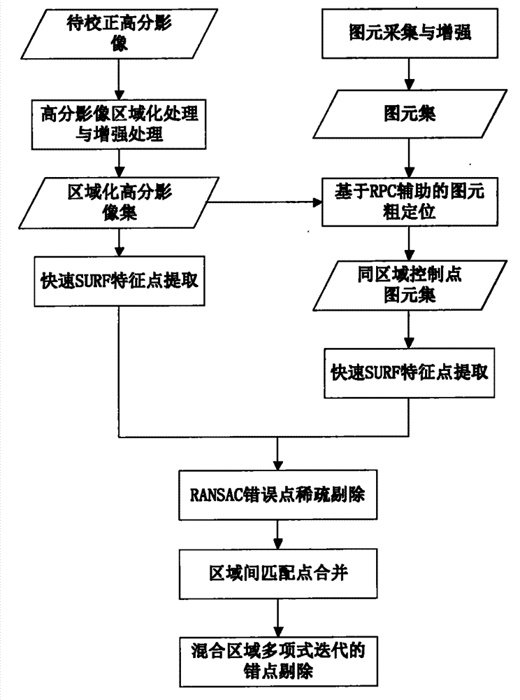
[0092] The specific implementation manners of the present invention will be further described in detail below in conjunction with the accompanying drawings and embodiments. The following examples are used to illustrate the present invention, but are not intended to limit the scope of the present invention.

[0093] Such as figure 1 As shown, it is a flowchart of a method for quickly matching control point primitives based on Gaofen-1 satellite data according to an embodiment of the present invention. This embodiment includes the following steps:

[0094] Step 10, graphic element collection and enhancement, obtaining a graphic element set;

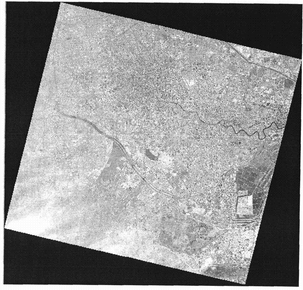
[0095] The primitive set of this example is obtained from such as figure 2 The 16-bit high-scoring reference image, because the high-scoring image is a 16-bit image, and the pixel values ​​​​are concentrated between 0 and 500, so the acquisition and enhancement methods are different from other images; currently, image registration in the...


PUM


Abstract

The invention belongs to the technical field of computer digital image processing and mode identification, and mainly relates to a remote sensing image rapid-registration method, in particular to a Gaofen-1 satellite data-based control point graphic element rapid-matching method. A basic flow comprises the following steps: performing centralized graphic element acquisition and enhancement processing on a Gaofen reference image to construct a graphic element database; performing regionalization and enhancement processing on an image to be corrected; acquiring a graphic element set of the same region by virtue of an RPC aided method; performing characteristic point extraction on the regionalized Gaofen image and the graphic element set of the same region, and acquiring a final matching result by virtue of methods of an RANSAC algorithm, polynomial error point iteration elimination and the like. According to the method, a Gaofen-1 satellite image can be registered independent of a massive-data reference image, and control point graphic elements of the corresponding regions of each Gaofen image can be found from the database to finish image registration to lay a good foundation for subsequent work in the future by continuously improving the control point graphic element database.

Description

technical field [0001] The invention belongs to the technical field of computer digital image processing and pattern recognition, and mainly relates to a fast registration method of remote sensing images, in particular to a fast matching method of control point graphic elements based on Gaofen-1 satellite data. Background technique [0002] Image registration is a basic technique in image processing, which is used to match two or more images from the same or different sensors with a certain geometric deformation between them. In remote sensing image processing, registration technology has always received great attention. It is an important link in remote sensing image mosaicking, multi-sensor information fusion, change detection and other related applications. The use of images, stereo vision and other fields is also becoming more and more extensive. [0003] At present, the main image registration methods at home and abroad are roughly divided into region-based registratio...

Claims


Application Information

Patent Timeline
IPC IPC(8): G06T7/00G06T5/00
Inventor 陈建胜何海涛赵东孟瑜王潇
Owner INST OF REMOTE SENSING & DIGITAL EARTH CHINESE ACADEMY OF SCI
Why Eureka
Try Eureka