A Real-time Terrain Estimation Method Based on Kernel Function

A kernel function and terrain technology, applied in the field of unmanned vehicle environment perception, can solve the problems of not being able to update online, difficult to adapt to complex terrain estimation, and large processing capacity, and achieve the effect of improving blind spots

Active Publication Date: 2017-08-29
BEIJING INSTITUTE OF TECHNOLOGYGY
View PDF1 Cites 0 Cited by
  • Summary
  • Abstract
  • Description
  • Claims
  • Application Information

AI Technical Summary

Problems solved by technology

The parametric surface representation method can only represent a relatively simple idealized surface, which is difficult to adapt to complex terrain estimation; the triangle / polygon network can only generate a discontinuous surface, and cannot be updated online, which is not suitable for terrain estimation of unmanned vehicle point cloud flow ; The implicit surface representation method can represent a continuous surface, and the radial basis function (RBF) it usually adopts is more in line with the requirement that each laser point can only affect its "surrounding terrain" in physical form, and it can be used step by step Point processing point cloud data flow, but the implicit surface representation method has the problems of large processing volume and inconvenient display

Method used


Image

  • A Real-time Terrain Estimation Method Based on Kernel Function
  • A Real-time Terrain Estimation Method Based on Kernel Function
  • A Real-time Terrain Estimation Method Based on Kernel Function

Examples


Embodiment Construction

[0044]The specific implementation manner of the present invention will be illustrated below with reference to the accompanying drawings.

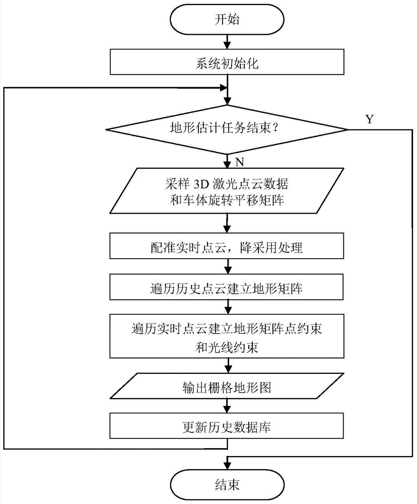
[0045] The present invention develops a real-time terrain estimation method based on a kernel function. The hardware implementation platform based on the method is an unmanned vehicle platform, which is equipped with sensors such as 64-line 3D laser radar and INS-GPS integrated navigation unit. .

[0046] Based on the above platform, the typical workflow first needs to perform system initialization, including: vehicle bottom layer initialization, sensor parameter initialization, vehicle attitude position initialization, terrain matrix establishment, variable scale kernel function template establishment; then determine whether the terrain estimation task is over, if it ends directly This method, otherwise, enters into a cyclic system workflow, and each processing cycle needs to include the following steps, such as figure 1 Shown:
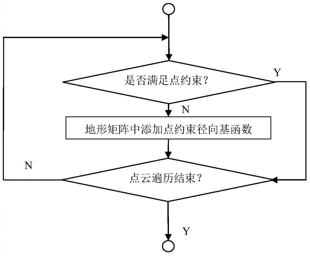
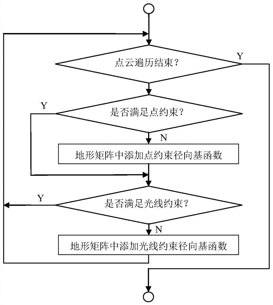
[0047] ...


PUM


Abstract

The invention provides a real-time terrain estimation method based on a kernel function. The specific process comprises the following steps: obtaining real-time point cloud data and a rotation and translation matrix of a vehicle current state relative to an absolute space; performing registration on the real-time point cloud data by utilizing the rotation and translation matrix, and adopting voxel-based downsampling processing for the point cloud data after the registration; traversing each point in a historical point cloud base, and building a terrain matrix MAP, which describes terrain of an estimated area, through adoption of point constraints; performing point constraints and light ray constraints on the terrain matrix MAP by utilizing the real-time point cloud data, and taking the terrain matrix MAP obtained at the moment as an estimation of current unmanned vehicle surrounding terrain; and adding the real-time point cloud data after the registration to the historical point cloud base, and updating historical point cloud data. The method can be suitable for terrain estimations of high real-time performance and massive data of an unmanned vehicle, solves compensation of a blind zone in a movement, and gives an explicit estimation result capable of performing on-line updating.

Description

technical field [0001] The invention relates to a kernel function-based real-time terrain estimation method, which belongs to the technical field of unmanned vehicle environment perception. Background technique [0002] When an unmanned vehicle is driving in an off-road environment, real-time terrain estimation is crucial for autonomous vehicle navigation. Compared with the structured driving environment, unmanned vehicles lack clear markers for identification in off-road environments, such as lane lines and road edges. At present, unmanned vehicles at home and abroad are generally equipped with 3D lidar. 3D lidar is an active sensor that can emit laser light and return point cloud data to obtain depth information of the surrounding environment. It is the main sensor for terrain estimation. [0003] It is easier to reconstruct the surrounding environment through laser point clouds in areas with dense point clouds or areas with flat terrain. However, the lidar point cloud s...

Claims


Application Information

Patent Timeline
Patent Type & Authority Patents(China)
IPC IPC(8): G06T7/30G06F19/00G01S17/89
Inventor 杨毅李星河付梦印朱昊
Owner BEIJING INSTITUTE OF TECHNOLOGYGY
Why Eureka
Try Eureka