Cooperation relative positioning method based on INS and GNSS pseudo-range double difference for VANET

A relative positioning and pseudo-range technology, which is used in satellite radio beacon positioning systems, traffic control systems for road vehicles, measurement devices, etc., can solve the problem of low positioning accuracy, improve positioning accuracy, correct measurement errors, and improve positioning. performance effect

Inactive Publication Date: 2015-08-12
NANJING UNIV OF POSTS & TELECOMM
View PDF5 Cites 22 Cited by
  • Summary
  • Abstract
  • Description
  • Claims
  • Application Information

AI Technical Summary

Problems solved by technology

[0012] The purpose of the present invention is to provide a cooperative relative positioning method based on INS and GNSS pseudo-range double differe

Method used


Image

  • Cooperation relative positioning method based on INS and GNSS pseudo-range double difference for VANET
  • Cooperation relative positioning method based on INS and GNSS pseudo-range double difference for VANET
  • Cooperation relative positioning method based on INS and GNSS pseudo-range double difference for VANET

Examples


Embodiment Construction

[0028] The invention will be described in further detail below in conjunction with the accompanying drawings.

[0029] Definitions of abbreviations and key terms relevant to the present invention:

[0030]

[0031]

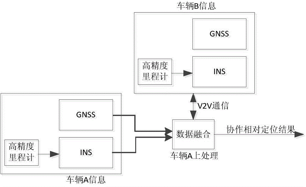
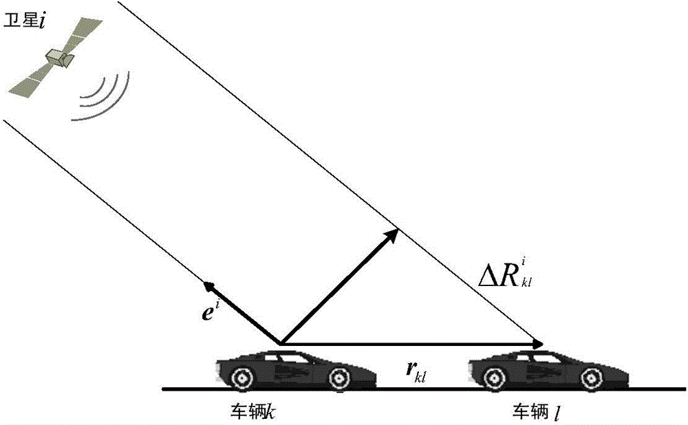
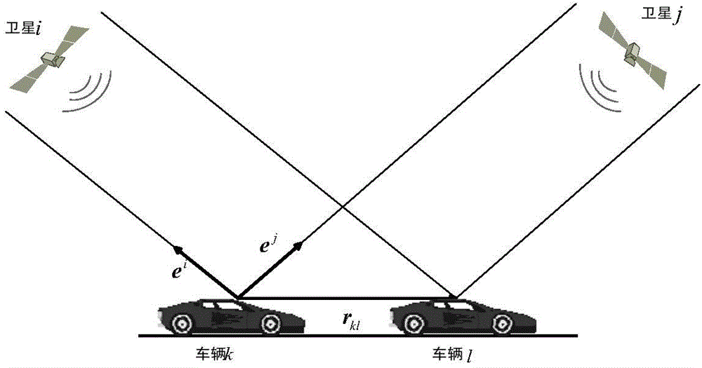
[0032] The precise vehicle position information of the present invention can provide services for many applications of ITS, including vehicle navigation and road safety, and the precise relative positioning between vehicles is sufficient to meet safety application requirements such as collision avoidance and road safety in VANET. Moreover, the use of relative positioning technology can eliminate the influence of some public errors and obtain better position information than absolute positioning. In areas with good GNSS signal coverage, the relative positioning between vehicles can be realized by pseudo-range double difference. For example, when using GNSS pseudo-range for positioning, the pseudo-range measurement value will be affected by error factors such ...


PUM


Abstract

The invention discloses a cooperation relative positioning method based on INS and GNSS pseudo-range double difference for a VANET. The vehicle-to-vehicle cooperation relative positioning method is high in positioning accuracy and high in applicability. The invention relates to vehicle positioning problems in GNSS signal non-blind zones, and mainly solves a vehicle relative positioning problem under a condition that a GNSS is low in positioning accuracy and is limited in applications. Firstly, accelerated speed information and vehicle GNSS position information which are provided by an INS and corrected by a high-precision odometer are shared through V2V communication between vehicles, so that corresponding information between the vehicles is shared. Secondly, information of the adjacent vehicle and information of the assigned vehicle are integrated and processed through the extended Kalman filtering technology, wherein the information is received through V2V communication, so that vehicle-to-vehicle relative positioning results of high accuracy are obtained.

Description

technical field [0001] The invention relates to inter-vehicle cooperative relative positioning technology based on INS and GNSS pseudo-range double-difference, in particular to a cooperative relative positioning method based on INS and GNSS pseudo-range double-difference in VANET. Background technique [0002] With the continuous improvement of people's living standards, the demand for vehicles has also begun to increase. While the increase in car ownership provides convenience for people's daily life, it also brings many problems to society, such as traffic accidents, traffic congestion and Environmental pollution and other issues. In recent years, the average number of deaths caused by road traffic accidents per year has reached more than 1.3 million, and the number of injured people has exceeded 50 million. According to existing data, if effective measures are not taken, it is estimated that by 2030, traffic accidents will become the fifth largest cause of human death. b...

Claims


Application Information

Patent Timeline
IPC IPC(8): G08G1/16G08G1/123G01S19/49G01S19/51
CPCG08G1/166G01S19/49G01S19/51
Inventor 黄波韩家群赵海涛李大鹏
Owner NANJING UNIV OF POSTS & TELECOMM
Why Eureka
Try Eureka