Method for rapidly judging position relation between points and polygon in GIS application

A polygon and decision point technology, applied in image data processing, instruments, calculations, etc., can solve problems such as difficult to deal with boundaries, vertices, boundary and ray collinearity, engineers locating faults, wrong decision-making, etc. The effect of fast location relationship, avoiding cumbersome processing, and narrowing the scope

Inactive Publication Date: 2015-08-19
INSPUR TIANYUAN COMM INFORMATION SYST CO LTD
View PDF2 Cites 8 Cited by
  • Summary
  • Abstract
  • Description
  • Claims
  • Application Information

AI Technical Summary

Problems solved by technology

If the cell within the polygon cannot be identified accurately and quickly, it will affect the maintenance engineer to locate the fault or even make a wrong decision
The Visual C++ library function PtInRegion provided by Microsoft can roughly realize this function, but PtInRegion does not always return the correct result reliably, especially when the point to be judged is located

Method used


Image

  • Method for rapidly judging position relation between points and polygon in GIS application
  • Method for rapidly judging position relation between points and polygon in GIS application
  • Method for rapidly judging position relation between points and polygon in GIS application

Examples


Embodiment

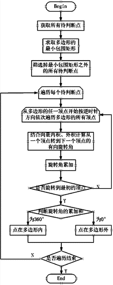
[0040] Embodiment: The following is an example of using the method of the present invention to identify network elements within a certain geographical range when polygons are used to circle network elements within a certain geographical range on a GIS map. The network elements on the map all have the basic geographic information of longitude and latitude. The premise of judging by the method of the present invention is that the latitude and longitude coordinates are converted into coordinates of a plane Cartesian coordinate system through Gaussian projection coordinate conversion. The coordinates of the network element after Gaussian projection coordinate transformation are used means, such as and many more.

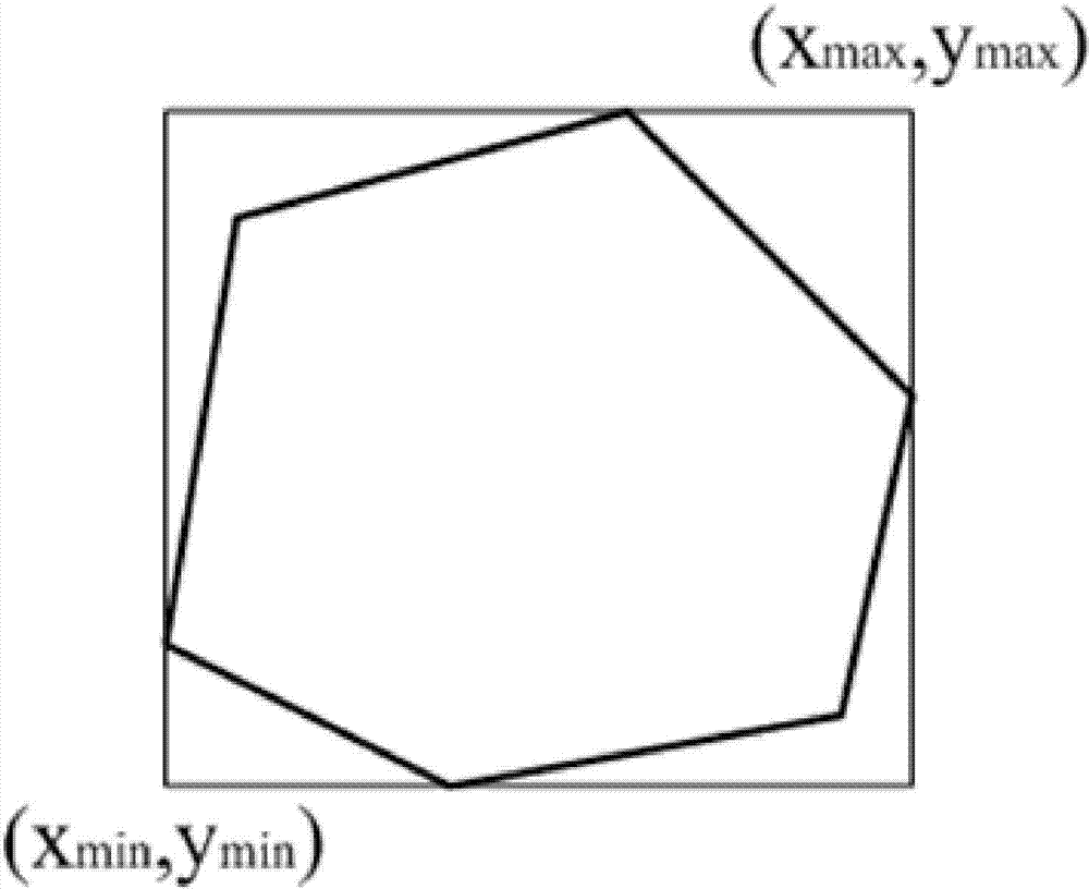
[0041] attached figure 2 The minimum enclosing rectangle of polygons is explained. Number the vertices of the polygon in counterclockwise order to obtain the sequence of polygon vertices: . Calculate the minimum value of the X coordinate in the polygon vertex co...


PUM


Abstract

The invention discloses a method for rapidly judging the position relation between points and a polygon in a GIS application. The concrete realization process is that all points to be judged are acquired; the minimum bounding rectangle of the polygon is obtained through solving; all the points to be judged outside the minimum bounding rectangle of the polygon are mass filtered; and the points inside the minimum bounding rectangle or the points arranged at the edges of the minimum bounding rectangle of the polygon are judged one by one by adopting a look around method until all the points are completely judged. Compared with methods in the prior art, the points outside the polygon can be rapidly filtered by the method for rapidly judging the position relation between the points and the polygon in the GIS application, range of the points to be judged can be reduced, calculation time can be greatly reduced, complex processing of the edge situations performed through a conventional ray method can be avoided, and thus the method is high in practicality and easy to popularize.

Description

technical field [0001] The present invention relates to a calculation method for quickly identifying network element entities in any polygon circled on a map in the application of geographic information system GIS, specifically a method for quickly determining the positional relationship between points and polygons in GIS applications with strong practicability . Background technique [0002] In GIS applications, the geographical distribution of mobile communication equipment network elements (such as base stations, cells, etc.) can be visually checked. When there is an alarm or fault caused by poor call quality in a certain area, the maintenance engineer will locate this area on the GIS, and circle a polygonal area, and then summarize and correlate the indicators of the cells in this area, and finally locate the The specific fault cell and the cause of the fault. This is a usage scenario that operators are very concerned about and urgent. The most basic thing to solve th...

Claims


Application Information

Patent Timeline
IPC IPC(8): G06T7/00
CPCG06T7/73
Inventor 王程英李建明刘延亮
Owner INSPUR TIANYUAN COMM INFORMATION SYST CO LTD
Why Eureka
Try Eureka