Cluster-based real-time rendering service of remote sensing data set

A technology of remote sensing data and real-time rendering, applied in image data processing, electrical digital data processing, special data processing applications, etc., to achieve fast query, exert efficiency and performance, and avoid network congestion

Inactive Publication Date: 2012-10-10
REMOTE SENSING APPLIED INST CHINESE ACAD OF SCI
View PDF4 Cites 40 Cited by
  • Summary
  • Abstract
  • Description
  • Claims
  • Application Information

AI Technical Summary

Problems solved by technology

[0007] The purpose of the present invention is to provide a systematic solution for clustering and fast rendering of massive multi-source remote sensing data sets, especially for massive remote sensing data and different types of data sets, to solve the problem of distributed organization and storage of data, multiple Joint query problem of data set and multi-mode parallel computing problem

Method used


Image

  • Cluster-based real-time rendering service of remote sensing data set
  • Cluster-based real-time rendering service of remote sensing data set
  • Cluster-based real-time rendering service of remote sensing data set

Examples


Embodiment Construction

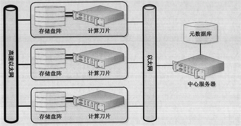
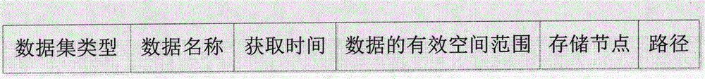
[0034]figure 1 It is the cluster environment topology structure used in the present invention: the central server installs MySQL database, manages the meta-information of the remote sensing data in the cluster, and connects with cluster nodes through ordinary Ethernet (100M); each cluster node consists of a computing blade and a disk Composed of storage arrays, the nodes are connected by high-speed Ethernet (gigabit). For each remote sensing data in the system, the content included in its meta-information (see figure 2 ) includes: data set type, data name, acquisition time, valid space range of data, storage node, path. The first four items are used to query the data within the tile space, and the last two items are used to resolve the corresponding storage location and path of the data. Among them, "dataset type" identifies different data types, for example, OrthorLandsatTM5 indicates the orthophoto dataset of TM5; "data name" is the unique identification of the data in the...


PUM


Abstract

The invention provides a systemic solution aiming at the rapid clustered rendering of a multisource remote sensing data set, which is especially used for solving distributed organization and storage problems of data and union query problems of a plurality of data sets in mass remote sensing data and different kinds of data sets. The systemic solution comprises the following steps: firstly allocating a cluster environment suitable for a real-time mass remote sensing data rendering system, wherein the cluster environment is formed by a plurality of calculation and data integrating nodes and a central server; sending a tile rendering request of a client side to the central server through a network channel, carrying out the research, the sieving and the post-processing through the central server so as to obtain a visible data list within the tile scope, and determining the optimal node according to the storage position; reading the tiles corresponding to the data by the nodes, rendering the tiles to a canvas in an overlying mode one by one, and sending the results to the central server; and finally sending the results to the client side by the central server. The systemic solution provided by the invention is suitable for rendered grain on the two-dimensional or three-dimensional surfaces, and large scale application fields, such as visualization and the like in the production of the terrain tile production and the large-scale remote sensing data management.

Description

technical field [0001] The invention relates to cluster computing technology and remote sensing data visualization technology, in particular to clustered tile data rendering technology of remote sensing data sets. The invention is applicable to the real-time rendering service of massive remote sensing data in the world. Background technique [0002] The overlay rendering of multi-source remote sensing data generally includes technical processes such as data pyramid construction, tile canvas creation, data reading, and sequential overlay rendering. Among them, the pyramid construction technology has been widely used. For example, ArcSDE of ESRI, GeoImageDB of Wuhan University, and SuperMap of SuperMap software have all realized the pyramid construction technology of images and improved the efficiency of data extraction. However, global data rendering involves issues such as multiple data sources, multi-band data extraction and overlay drawing, data source update and interact...

Claims


Application Information

Patent Timeline
Patent Type & Authority Applications(China)
IPC IPC(8): G06F17/30G06F9/50G06T11/00G06T15/00
Inventor 胡晓东骆剑承周亚男沈占锋李红旮郜丽静
Owner REMOTE SENSING APPLIED INST CHINESE ACAD OF SCI
Why Eureka
Try Eureka