
Offline reverse geocoding method, device thereof and terminal equipment

A technology of geocoding and geographical location, applied in the field of offline reverse geocoding, which can solve the problems that terminal equipment cannot complete reverse geocoding, network dependence, etc.

Active Publication Date: 2015-08-26
ALIBABA (CHINA) CO LTD
View PDF6 Cites 11 Cited by
  • Summary
  • Abstract
  • Description
  • Claims
  • Application Information

AI Technical Summary

Problems solved by technology

[0004] In the existing technology, the inverse geocoding of latitude and longitude coordinates needs to be completed through the server side, which relies heavily on the network, resulting in the technical problem that the inverse geocoding cannot be completed when the terminal device cannot be connected to the Internet.

Method used


Image

  • Offline reverse geocoding method, device thereof and terminal equipment
  • Offline reverse geocoding method, device thereof and terminal equipment
  • Offline reverse geocoding method, device thereof and terminal equipment

Examples


Embodiment Construction

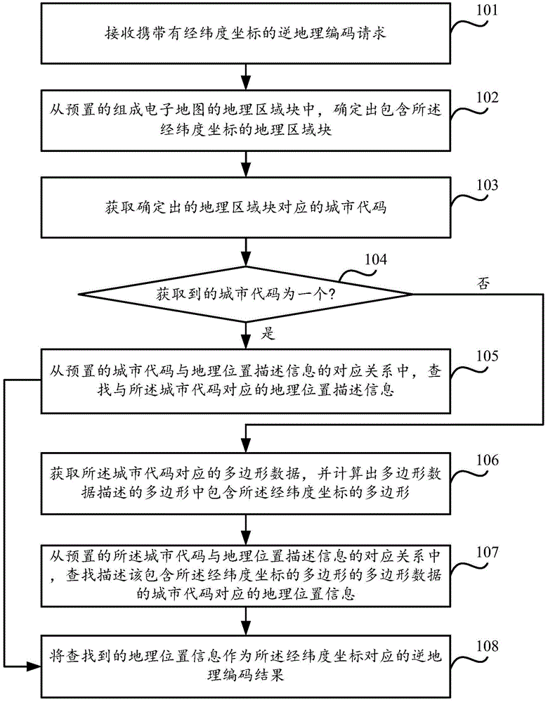
[0028] see figure 1 , which is a flowchart of an offline reverse geocoding method provided in an embodiment of the present invention, the method is applied to a terminal device, and the method includes:

[0029] Step 101. Receive an inverse geocoding request carrying latitude and longitude coordinates.

[0030] Step 102: Determine the geographic area block including the longitude and latitude coordinates from the preset geographic area blocks constituting the electronic map.

[0031] In the embodiment of the present invention, the electronic map is divided into multiple geographical area blocks in advance, and the geographical area blocks can be rectangles or squares with the same size, or the geographical area blocks divided for different provinces and cities have different sizes, such as For densely populated areas (such as Beijing, Shanghai, Shenzhen, Guangzhou, Hangzhou, etc.), the size of the geographical area blocks divided is smaller than that of sparsely populated are...


PUM


Abstract

The present invention discloses an offline reverse geocoding method, a device thereof and terminal equipment to solve the technical problem that networking is needed by reverse geocoding in the prior art and thus the reverse geocoding can not be completed when the terminal equipment can be not networked. The method comprises a step of determining a geographical area block containing latitude and longitude coordinates and obtaining the city codes corresponding to the geographical area block when a reverse geocoding request carrying the latitude and longitude coordinates is received, a step of taking the geographical position description information corresponding to the city code as the reverse geocoding result corresponding to the latitude and longitude coordinates when one city code is obtained, and a step of selecting one city code according to the polygon data of the plurality of city codes when multiple city codes are obtained and taking the geographical position description information corresponding to the city code as the reverse geocoding result corresponding to the latitude and longitude coordinates. According to the technical scheme, the reverse geocoding is realized by the terminal equipment locally and can be realized without networking.

Description

technical field [0001] The invention relates to the field of electronic maps, in particular to an off-line reverse geocoding method, its device and terminal equipment. Background technique [0002] At present, on terminal devices (such as mobile phones, navigators, etc.), determine the geographical location description information corresponding to a longitude and latitude coordinate (such as the description information of the province, city, district, etc. where the longitude and latitude coordinates are located, specific examples such as "Wuhan City, Hubei Province Wuchang District"), the latitude and longitude coordinates need to be uploaded to the server for inverse geocoding. The server performs inverse geocoding on the uploaded latitude and longitude coordinates according to the set inverse geocoding algorithm, and feeds back the inverse geocoding result to the terminal device. Then the terminal device analyzes the inverse geocoding result and presents it to the user. ...

Claims


Application Information

Patent Timeline
IPC IPC(8): G09B29/10G06F17/30
CPCG06F16/29G09B29/10
Inventor 段航
Owner ALIBABA (CHINA) CO LTD
Learn More