Processing method and search method for multiple-source and multi-temporal satellite image tile data

A satellite image and data processing technology, which is applied in still image data retrieval, electronic digital data processing, special data processing applications, etc., can solve the problem of multi-source heterogeneous and multi-version image tile data without organizational processing methods and metadata without Efficiently handles, does not provide diverse spatial searches, etc.

Active Publication Date: 2015-09-09
北京博阳世通信息技术有限公司 +1
View PDF4 Cites 27 Cited by
  • Summary
  • Abstract
  • Description
  • Claims
  • Application Information

AI Technical Summary

Problems solved by technology

[0003] There are two main problems in the processing of massive remote sensing image data: First, with the massive growth of image data, what method can be used to reasonably and efficiently organize storage and process these geographically distributed data with multi-source heterogeneity, multi-temporal and multi-version Image data, to achieve unified storage organization specifications and real-time sharing and rapid release services; second, as users' demand for remote sensing image data becomes more and more extensive and demanding, how to quickly and accurately retrieve data from massive remote sensing data sources Find remote sensing imag

Method used


Image

  • Processing method and search method for multiple-source and multi-temporal satellite image tile data
  • Processing method and search method for multiple-source and multi-temporal satellite image tile data
  • Processing method and search method for multiple-source and multi-temporal satellite image tile data

Examples


Embodiment example 1

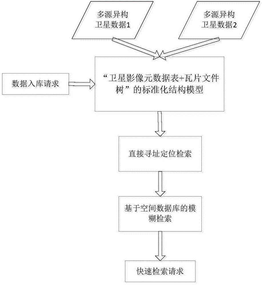
[0064] see Figure 4 , Implementation Case 1 of the present invention provides a process for storing multi-source and multi-temporal satellite image data, including four steps: extracting metadata, registering metadata, data slicing, and tile data storage.

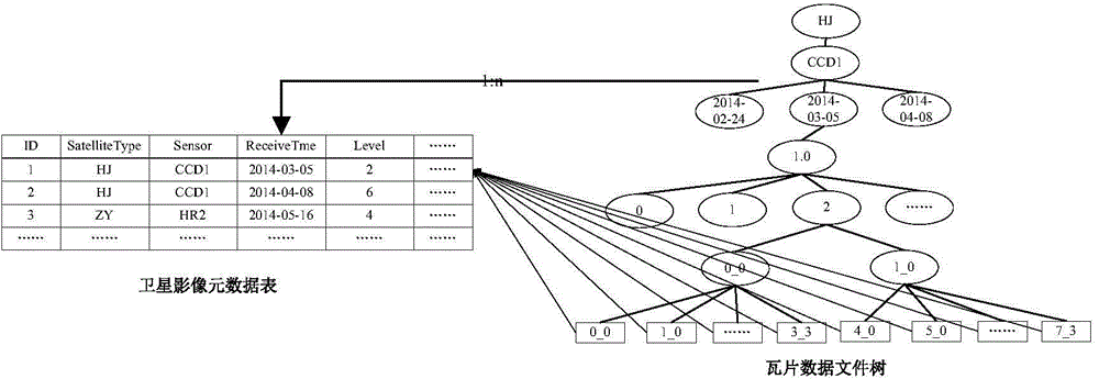
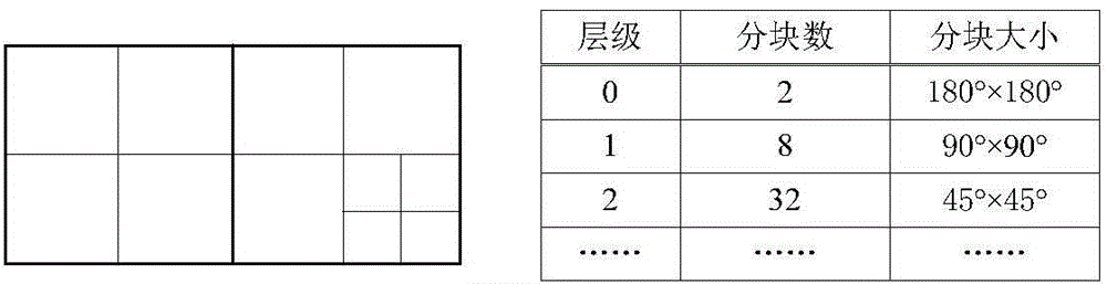
[0065] Step 1: Extract image metadata. Read satellite metadata from satellite image data files, including information such as spatial extent, satellite type, sensor type, product grade, imaging time, and version number. According to the spatial range and tile structure of the image, information such as the tile structure level where the image is located, the sequence number of the start and end blocks in the row and column directions, etc. are calculated.

[0066] Step 2: Register metadata. Register image metadata in the image metadata table.

[0067] Step 3: Data slicing. According to the spatial range and tile structure of the image, the image data is sliced ​​horizontally into blocks and vertically layered to form t...

Embodiment example 2

[0083] Implementation Case 2 of the present invention provides a fast retrieval mechanism for massive multi-source multi-temporal tile data, including the following steps:

[0084] Step 1: According to the fuzzy search conditions, search the image metadata records of the symbolic conditions in the database.

[0085] Step 2: Calculate the row and column number range of the target tile according to the retrieval space area.

[0086] Step 3: Combine accurate tile information according to the image metadata records and the row and column number range of the target tile.

[0087] Step 4: Perform direct addressing based on the precise tile retrieval condition in Step 3 to obtain tile data.

[0088] The steps are described in detail below:

[0089] The image metadata records of symbolic conditions in the search database described in step 1, that is, based on the integrated query and retrieval of "spatial-attribute" and "vector-raster" of the spatial database BeyonDB, ...


PUM


Abstract

The invention discloses a processing method for multiple-source and multi-temporal satellite image tile data. According to the processing method, a mass tile data organization structure with the time-space characteristic and the multi-source heterogeneous characteristic can be constructed, and metadata of multi-source heterogeneous satellite data tiles can be processed. The processing method comprises the steps of: (1) inputting a plurality of pieces of satellite image data, wherein each satellite image data comprises pixel data and metadata; (2) receiving a data warehousing request; (3) storing each metadata based on an image metadata table of BeyonDB, wherein each row of record description of the image metadata table comes from the metadata of the tile data of the same satellite image, and a plurality of pieces of tile data correspond to the same satellite metadata record; and (4) processing the pixel data by adopting a transverse blocking and longitudinal layering tile structure, and storing the mass tile data after processing the mass tile data by adopting a multiple-source and multi-temporal pyramid tile data file tree structure. The invention also provides a processing system, as well as a search method and a search system based on the processing system.

Description

technical field [0001] The invention belongs to the technical field of earth observation and navigation, and in particular relates to a processing method and system for multi-source multi-temporal satellite image tile data, and retrieval of multi-source multi-temporal satellite image tile data based on the processing method method, retrieval system. Background technique [0002] With the rapid development of my country's earth observation technology, an earth observation system with space-time coordination, all-weather, and all-time has been formed, and a large amount of remote sensing image data can be obtained. Remote sensing image data is growing at a geometric rate, and has the characteristics of multiple sources, multiple types, multiple resolutions, multiple temporal states, and multiple versions, which has brought great challenges to its storage, processing, release and sharing. problems and challenges. [0003] There are two main problems in the processing of massi...

Claims


Application Information

Patent Timeline
IPC IPC(8): G06F17/30
CPCG06F16/245G06F16/51G06F16/56G06F16/58
Inventor 姜平谢炯陈荣国李翔翔张攀攀
Owner 北京博阳世通信息技术有限公司
Why Eureka
Try Eureka