Supercharge Your Innovation With Domain-Expert AI Agents!

Texture segmentation and fusion based radar remote-sensing image artificial building recognition algorithm

A remote sensing image and texture segmentation technology, which is applied in character and pattern recognition, computing, computer parts, etc., to achieve the effect of improving recognition accuracy, low computational complexity, and easy implementation

Inactive Publication Date: 2015-09-09
HENAN POLYTECHNIC UNIV
View PDF2 Cites 17 Cited by
  • Summary
  • Abstract
  • Description
  • Claims
  • Application Information

AI Technical Summary

Problems solved by technology

[0005] Aiming at the deficiencies in the existing technology, the purpose of the present invention is to provide a radar remote sensing image artificial building recognition algorithm based on texture segmentation and fusion, which solves the problem of effectively using the spatial texture features of synthetic aperture radar (SAR) remote sensing data to extract building information with high precision. The problem

Method used


Image

  • Texture segmentation and fusion based radar remote-sensing image artificial building recognition algorithm
  • Texture segmentation and fusion based radar remote-sensing image artificial building recognition algorithm
  • Texture segmentation and fusion based radar remote-sensing image artificial building recognition algorithm

Examples


Embodiment 1

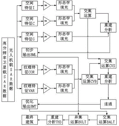
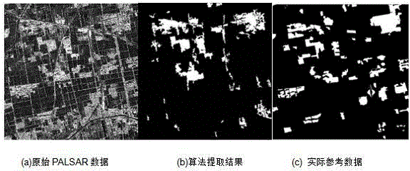
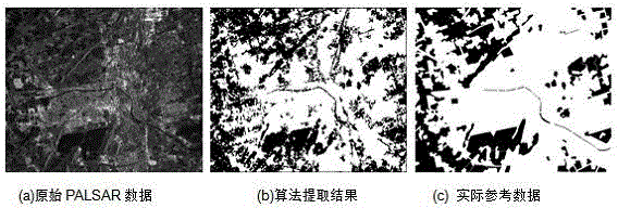
[0067] Embodiment 1: The artificial building recognition algorithm of UAV-borne / space-borne radar remote sensing images based on texture segmentation and fusion is the same as the specific implementation method, figure 2 (a) and image 3 (a) is the original image of spaceborne SAR remote sensing used by the present invention, which is the phased array L-band synthetic aperture radar (PALSAR) sensor data of Japan's earth observation satellite ALOS, which is not affected by clouds, weather and day and night, and can be used for All-weather and all-weather land observation, the acquisition time is November 12, 2008, the polarization mode is HH, the spatial resolution is 10m, and the coverage area is the coal mine area to the east of Jiawang District, Xuzhou City, Jiangsu Province, the coal mine area to the west of Tongshan County and Xuzhou urban area. In order to verify the effectiveness of the method of the present invention, UAV-borne SAR data is used for verification. The ...


PUM


Abstract

The present invention discloses texture segmentation and fusion based radar remote-sensing image artificial building recognition algorithm. The algorithm comprises the following steps of: determining image segmentation scale factors and logic mask segmentation scales according to sensor types; searching, calculating and screening space autocorrelation structure index features and gray scale co-occurrence matrix texture features; performing logic masking on space feature indexes and texture information according to the mask scales; operating and filtering mask results according to mathematical morphology; performing primary logical clustering on filtration results, and searching obvious building regions; performing secondary logical clustering according to primary search results, and rebuilding the algorithm in combination with the mathematical morphology; updating and perfecting the obvious building regions; rebuilding the sections through the mathematical morphology; and finally accurately obtaining a building information recognition result. The recognition ability of the mathematical morphology and the logical clustering on an SAR (synthetic aperture radar) image building is maximally excavated; and the final recognition precision of building information can be improved.

Description

technical field [0001] The invention relates to the technical field of remote sensing pattern recognition, in particular to a radar remote sensing image artificial building recognition algorithm based on texture segmentation and fusion. Background technique [0002] The ecological environment is the most complex structure and the basis for the continuous creation of human social civilization. Its two main characteristics are: growth and dynamics. This increases the complexity of analyzing and understanding the use of remote sensing data. With the development of society and economy and the advancement of science and technology, the process of socialization is accelerating, and artificial surfaces (especially impermeable layers such as buildings and roads) are gradually replacing natural landscapes such as vegetation, causing urban land use / coverage problems. fundamental changes. Compared with optical satellite images, SAR satellite images have all-day and all-weather charac...

Claims


Application Information

Patent Timeline
IPC IPC(8): G06K9/00
CPCG06V20/176G06V10/54
Inventor 刘培韩瑞梅邹友峰王双亭马超蔡来良成晓晴
Owner HENAN POLYTECHNIC UNIV
Features
  • R&D
  • Intellectual Property
  • Life Sciences
  • Materials
  • Tech Scout
  • Unparalleled Data Quality
  • Higher Quality Content
  • 60% Fewer Hallucinations
Learn More