
Positioning method and apparatus for unmanned aerial vehicle

A technology of unmanned aerial vehicles and positioning methods, applied in the field of positioning of unmanned aerial vehicles, can solve the problems of inability to hover at fixed points, inability to realize satellite positioning, and inability to solve satellite positioning accuracy, so as to achieve the effect of optimizing flight experience and improving safety

Inactive Publication Date: 2015-09-23
SHENZHEN HIGHGREAT TECH DEV CO LTD
View PDF8 Cites 26 Cited by
  • Summary
  • Abstract
  • Description
  • Claims
  • Application Information

AI Technical Summary

Problems solved by technology

However, although the above scheme provides a real-time update of the flight attitude information of the aircraft, it still cannot solve the problem of being unable to hover at a fixed point when the satellite positioning accuracy is poor or cannot be realized. Method and device for realizing positioning of unmanned aircraft based on data such as information

Method used


Image

  • Positioning method and apparatus for unmanned aerial vehicle
  • Positioning method and apparatus for unmanned aerial vehicle
  • Positioning method and apparatus for unmanned aerial vehicle

Examples


Embodiment 1

[0082] Please refer to Figure 4 and 5 , Embodiment 1 of the present invention is:

[0083] A positioning method for an unmanned aerial vehicle is provided, comprising the following steps:

[0084] 1. Start the video stream assisted positioning system;

[0085] 2. Obtain real-time images through the camera 1 arranged on the fuselage of the unmanned aerial vehicle, and obtain the height information and attitude information of the unmanned aerial vehicle;

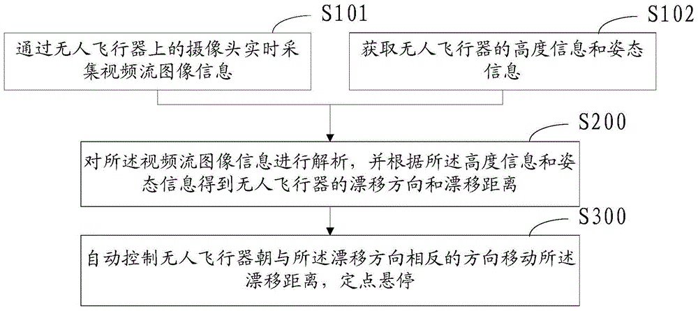
[0086] 3. Calculate the drift direction and drift distance of the UAV in real time; specifically include:

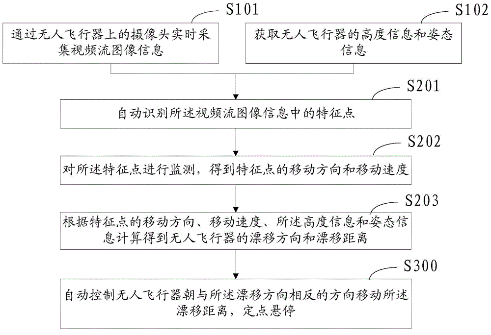
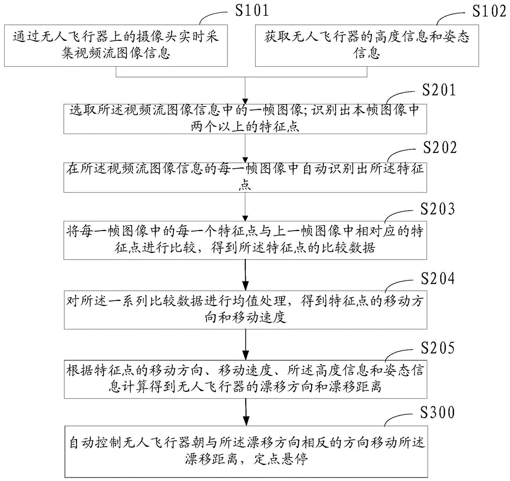
[0087] Image acquisition: automatically identify a certain number of feature points on the image (which can be understood as pixels that are more prominent in the image relative to the background environment of the image), and monitor the moving direction and speed of these pixels at the same time. The data is averaged, combined with the state of the aircraft at this time, to obtain the drift direction and distance ...

Embodiment 2

[0090] Please refer to Figure 10 , the second embodiment of the present invention is:

[0091] A positioning system for an unmanned aerial vehicle, comprising a satellite signal positioning module, a video signal acquisition module, an acquisition module 2, an analysis module 3 and an automatic control module 4;

[0092] The satellite signal positioning module can be a GPS device; the video signal acquisition module includes a camera 1; the acquisition module 2 preferably includes a height information acquisition module and an attitude information acquisition module; the analysis module 3 is preferably an information processing module; The automatic control module 4 is preferably a flight control module and an information output module.

[0093] The unmanned aerial vehicle of the present invention may or may not be equipped with a GPS device for satellite positioning. The video stream positioning system of the unmanned aerial vehicle of the present invention can also indepen...


PUM


Abstract

The invention provides a positioning method and a system for an unmanned aerial vehicle. The method includes: acquiring video streaming image information in real time via a camera of the unmanned aerial vehicle; obtaining height information and attitude information of the unmanned aerial vehicle; obtaining the drift direction and drift distance of the unmanned aerial vehicle according to the parsing of the video streaming image information by the height information and the attitude information; and automatically controlling the unmanned aerial vehicle to move for the drift distance towards the direction opposite to the drift direction, and stabilizing the position of the unmanned aerial vehicle. According to the positioning method, the unmanned aerial vehicle can realize spot hover without a satellite positioning system or with poor precision of satellite positioning signals, or without providing specific control amount, the security of the unmanned aerial vehicle is improved, especially the security of indoor flight, and flight experience for control personnel can be optimized.

Description

technical field [0001] The invention relates to the technical field of aircraft, in particular to a positioning method and device for an unmanned aircraft. Background technique [0002] Nowadays, due to the needs of all walks of life, unmanned aerial vehicles are used more and more widely. With continuous development, more unmanned aerial vehicles with faster flying speed, higher flying altitude, more flexible operation and smaller volume have emerged. aircraft. With the continuous increase of flight speed and flight altitude, and the smaller and smaller aircraft body, the performance requirements of the aircraft itself are getting higher and higher. Specifically, the improvement of the flight speed and altitude of the aircraft will cause the aircraft to meet the control requirements according to the control requirements. The difficulty of hovering is increased; when small aircrafts fly indoors or in relatively hidden places, they cannot achieve fixed-point hovering due to ...

Claims


Application Information

Patent Timeline
IPC IPC(8): G05D1/10
Inventor 高建民
Owner SHENZHEN HIGHGREAT TECH DEV CO LTD
Learn More