Real-time orbit determination method for drift scanning geosynchronous satellite

A technology for scanning synchronous and synchronous satellites, applied in the direction of integrated navigators, etc., can solve the problems of difficulty in meeting the real-time and accuracy requirements of synchronous satellite orbit determination, large amount of calculation, low recognition hit rate, etc., to avoid calculation and large capacity Store, improve extraction accuracy, and achieve rapid recognition effects

Inactive Publication Date: 2015-09-30
SUZHOU UNIV OF SCI & TECH
View PDF7 Cites 9 Cited by
  • Summary
  • Abstract
  • Description
  • Claims
  • Application Information

AI Technical Summary

Problems solved by technology

The two methods have a large amount of calculation and a low recognition hit rate, and it is di...

Method used


Image

  • Real-time orbit determination method for drift scanning geosynchronous satellite
  • Real-time orbit determination method for drift scanning geosynchronous satellite
  • Real-time orbit determination method for drift scanning geosynchronous satellite

Examples


Embodiment Construction

[0050] The present invention will be described in detail below with reference to the accompanying drawings and in combination with embodiments.

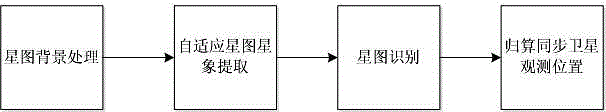
[0051] refer to figure 1 As shown, a drift scanning geostationary satellite real-time orbit determination method, the method mainly includes the following steps:

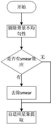
[0052] Step 1) Process the background of the star map to make the background pixels evenly distributed and remove the smear phenomenon;

[0053] Step 2) Adaptively extract the star image in the star map, including the barycentric coordinates of the stellar image and the barycentric coordinates of the synchronous satellite image, and obtain the measurement coordinates of the two;

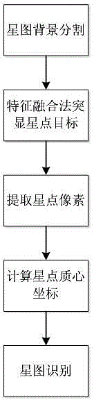
[0054] Step 3) Identify the stellar map and save the matching data obtained from all stellar images;

[0055] Step 4) Calculate the observation position of the geosynchronous satellite, calculate the CCD film model parameters through the stellar astrology, obtain the relationship between the meas...


PUM


Abstract

The invention discloses a real-time orbit determination method for a drift scanning geosynchronous satellite. The method comprises the following steps: firstly, processing a star map background to ensure uniform distribution of background pixels, and removing smear if a smear phenomenon occurs; detecting star points in a self-adaptive manner, segmenting an image background, highlighting star images through a feature fusion method, extracting a star image target, and calculating mass center coordinates of the star points; matching and identifying the star images through an improved triangle method, namely, extracting a star image with maximum gray value for triangle matching, performing reduction to obtain CCD negative model parameters according to the matching result, substituting all the star images into a negative model to calculate corresponding celestial coordinates, and matching the celestial coordinates with a star catalogue; and finally, performing reduction on the CCD negative model according to the matching identification result, and substituting geosynchronous satellite coordinates into the CCD negative model to calculate the optical position of the geosynchronous satellite, thereby completing orbit determination of the geosynchronous satellite. The method is high in precision and speed and good in real time property, and is free of bid data calculation and storage.

Description

technical field [0001] The invention belongs to the technical field of synchronous satellite astronomical observation and astrometry, and in particular relates to a method for real-time orbit determination of a drift-scanning synchronous satellite. Background technique [0002] In terms of space communication, earth detection and space science, the geosynchronous orbit is a space neighborhood with very important value. Milli-arcseconds improved to sub-milliarcseconds. At this stage, the orbit determination of geostationary satellites mainly adopts the CCD drift scanning method, that is, the short-frame CCD staring mode and the drift scanning mode are used to alternately observe the stars and the geostationary satellites, alternately obtain good circular star images of the stars and geosynchronous satellites, and use the stars as a reference model to calculate The CCD negative film model thus calculates the orbit of the geostationary satellite. The traditional geostationary...

Claims


Application Information

Patent Timeline
IPC IPC(8): G01C21/24
CPCG01C21/24
Inventor 王军杨会玲柳红岩李岩于勇孙慧婷
Owner SUZHOU UNIV OF SCI & TECH
Why Eureka
Try Eureka