A method for three-dimensional display and blind area determination of electromagnetic signals received by UAV on the ground

An electromagnetic signal, ground receiving technology, applied in three-dimensional position/channel control, image data processing, 3D modeling and other directions, can solve the problem of electromagnetic environment with large amount of electromagnetic signal strength data

Active Publication Date: 2018-06-12
BEIHANG UNIV
View PDF3 Cites 2 Cited by
  • Summary
  • Abstract
  • Description
  • Claims
  • Application Information

AI Technical Summary

Problems solved by technology

[0004] Aiming at the needs of link information monitoring and route planning during the flight of UAVs, as well as the large amount of electromagnetic signal strength data and the abstraction of the electromagnetic environment, the present invention proposes a three-dimensional display and blind area of ​​electromagnetic signals received by UAVs on the ground determination method

Method used


Image

  • A method for three-dimensional display and blind area determination of electromagnetic signals received by UAV on the ground
  • A method for three-dimensional display and blind area determination of electromagnetic signals received by UAV on the ground
  • A method for three-dimensional display and blind area determination of electromagnetic signals received by UAV on the ground

Examples


Embodiment Construction

[0027] The present invention will be further described below in conjunction with the accompanying drawings and specific implementation examples.

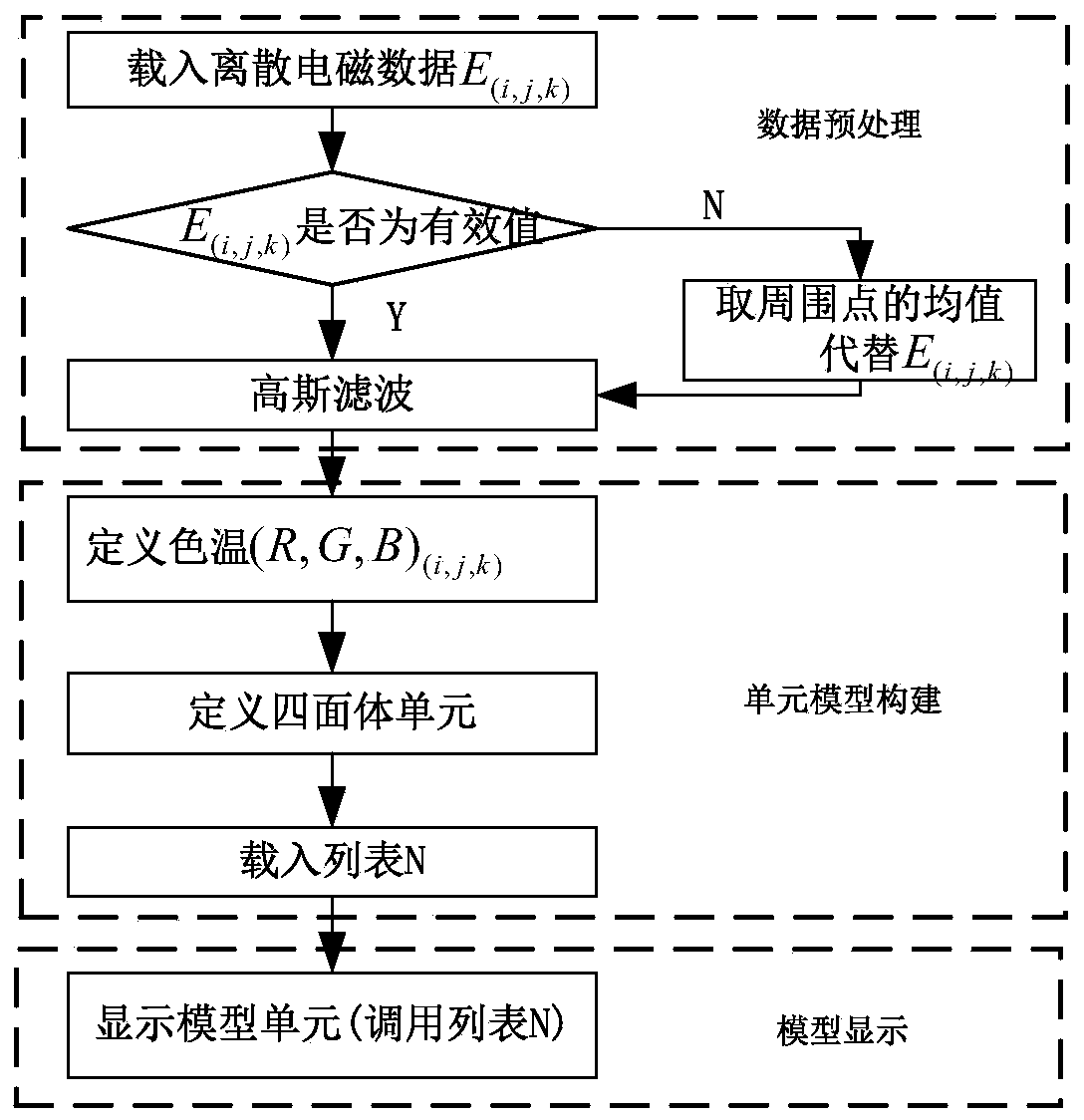
[0028] The three-dimensional display and blind area determination method of the ground receiving electromagnetic signal of the UAV proposed by the present invention realizes the three-dimensional visualization of data based on the electromagnetic signal strength value received near the ground station, and judges whether there is a receiving blind area. The specific process is as follows figure 1 As shown, the method of the present invention specifically includes the following three steps.

[0029] Step 1. Electromagnetic signal strength data acquisition and preprocessing, including the following steps 1.1 to 1.5:

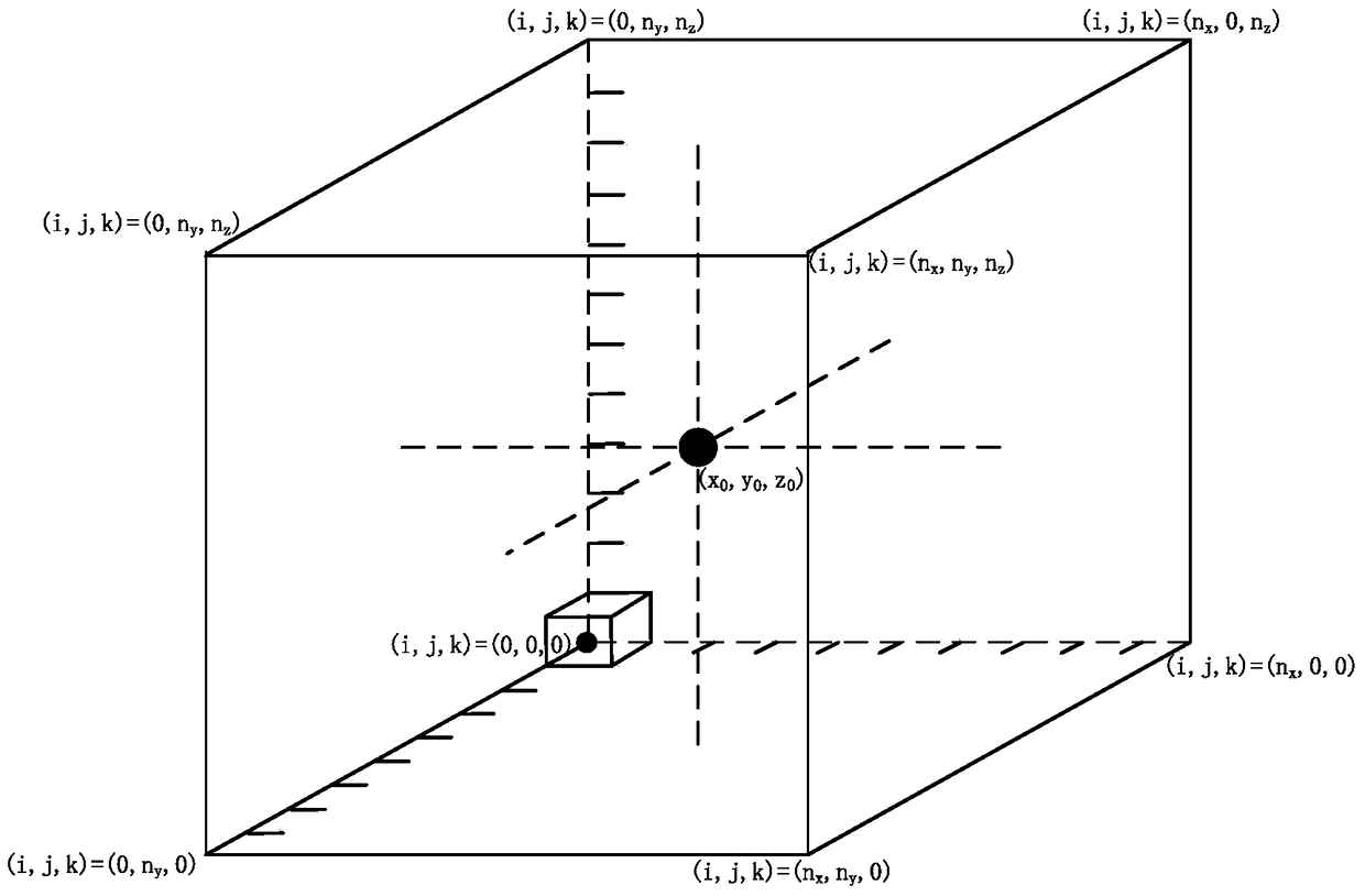
[0030] Step 1.1. Set the grid range, that is, the area range of the electromagnetic signal strength received by the ground station, and use it as a model unit for the three-dimensional visualization of the data. The speci...


PUM


Abstract

The invention discloses a three-dimensional display and blind area determination method for unmanned aerial vehicles receiving electromagnetic signals on the ground. Firstly, the downlink data of the communication data link is read through the network data reading method, and the electromagnetic signal strength of the area near the ground receiving station is extracted therefrom, and Perform data filtering and preprocessing operations. Then, according to the receiving position and numerical value of the data, the unit modeling and attribute definition of the three-dimensional visualization display model are carried out. Finally, using computer graphics technology, the three-dimensional visualization operation of data is loaded into different display lists according to the flight distance of the UAV, so as to realize the three-dimensional visualization display of data. Then, the method of threshold judgment is used to determine the position of the blind area of ​​communication, adjust the route direction, and obtain the best planned route. The invention can dynamically display the electromagnetic signal strength of the ground receiving end during the flight of the drone in real time, and is suitable for link information monitoring and route planning under multi-link and multi-channel.

Description

technical field [0001] The invention belongs to the technical field of command and control of unmanned aerial vehicles, relates to the fields of computer graphics, electromagnetic environment, etc., and specifically refers to a three-dimensional display and communication blind area determination method for realizing electromagnetic signals received by unmanned aerial vehicles on the ground. Background technique [0002] With its accurate, efficient and flexible reconnaissance, interference, search and combat capabilities in irregular conditions, unmanned aircraft play a significant role in modern warfare. The ground station is the command and control center of the UAV system, and the UAV telemetry and remote control ground station is called the "nerve center" of the entire UAV system, which plays a very important role in the normal operation of the system. Therefore, the UAV has the disadvantage of single point failure, that is, once the ground station loses the normal link ...

Claims


Application Information

Patent Timeline
Patent Type & Authority Patents(China)
IPC IPC(8): G06T17/00G05D1/10
Inventor 丁文锐陈彦冠刘春辉向锦武
Owner BEIHANG UNIV
Why Eureka
Try Eureka