Multi-satellite remote sensing data processing system

A remote sensing data and processing system technology, which is applied in the field of multi-satellite remote sensing data processing system, can solve the problem that the data processing system is not suitable for multi-satellite remote sensing data processing, and achieve the effect of improving the use efficiency

Inactive Publication Date: 2015-11-25
SPACE STAR TECH CO LTD
View PDF5 Cites 20 Cited by
  • Summary
  • Abstract
  • Description
  • Claims
  • Application Information

AI Technical Summary

Problems solved by technology

[0005] The technical problem to be solved by the present invention is to provide a multi-satellite remote sensing data processing system, which is used to solve the problem that the traditional remote sensing ground station data processing system is not suitable for multi-satellite remote sensing data processing

Method used


Image

  • Multi-satellite remote sensing data processing system
  • Multi-satellite remote sensing data processing system
  • Multi-satellite remote sensing data processing system

Examples


Embodiment Construction

[0049] The principles and features of the present invention are described below in conjunction with the accompanying drawings, and the examples given are only used to explain the present invention, and are not intended to limit the scope of the present invention.

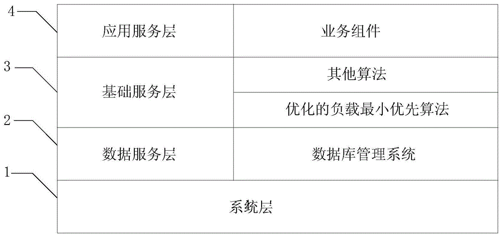
[0050] Such as figure 1 As shown, this embodiment provides a multi-satellite remote sensing data processing system, including:

[0051]System layer 1, used to provide the software support environment for the multi-satellite remote sensing data processing system;

[0052] Data service layer 2, used to store remote sensing data and configuration information of the multi-satellite remote sensing data processing system;

[0053] Basic service layer 3 is used to provide cloud platform-level cluster services to the multi-satellite remote sensing data processing system. It manages all resource nodes in the cluster through the configured load balancing scheduler, and according to the scheduling algorithm integrated in the ...


PUM


Abstract

The present invention discloses a multi-satellite remote sensing data processing system, comprising: a system layer, a data service layer, a basic service layer and an application service layer, wherein the system layer is used for providing a software supporting environment; the data service layer is used for storing remote sensing data and configuration information; the basic service layer is used for controlling different resource nodes to process remote sensing data of different satellites by a load balancing scheduler according to a scheduling algorithm; and the application service layer is used for performing task scheduling and process control of the multi-satellite remote sensing data by a service component and the load balancing scheduler of the basic service layer. Adoption of the multi-satellite remote sensing data processing system solves the problem of establishing a plurality of sets of processing systems for a plurality of satellites in a conventional mode and a load balancing mechanism of multi-task scheduling is provided.

Description

technical field [0001] The invention relates to the field of remote sensing data processing, in particular to a multi-satellite remote sensing data processing system. Background technique [0002] Traditional remote sensing ground station data processing systems need to establish multiple sets of processing systems for multiple satellites, which greatly increases the hardware equipment of traditional remote sensing ground stations, and because different equipment only process data from different satellites, the resource utilization rate of these hardware equipment Also relatively low. Therefore, with the rapid increase in the number of remote sensing satellites owned by our country, the traditional remote sensing ground station data processing system can no longer meet the needs of applications. [0003] With the continuous development of cluster load scheduling algorithms and load balancing technologies, more and more technicians are considering using load balancing when u...

Claims


Application Information

Patent Timeline
Patent Type & Authority Applications(China)
IPC IPC(8): G06F9/50G06F9/48
Inventor 李霖刘华汪红强魏晓珂
Owner SPACE STAR TECH CO LTD
Why Eureka
Try Eureka