Drawing method of power network wind zone distribution map in mountainous area

A distribution map and wind area technology, applied in the direction of electrical digital data processing, special data processing applications, instruments, etc., can solve the needs of "wind deviation" accident prevention and control work, lack of theoretical support, lack of data collection, collection statistics Issues such as arguments for modeling comparisons

Active Publication Date: 2015-11-25
ELECTRIC POWER SCI RES INST OF GUIZHOU POWER GRID CO LTD +1
View PDF3 Cites 20 Cited by
  • Summary
  • Abstract
  • Description
  • Claims
  • Application Information

AI Technical Summary

Problems solved by technology

[0003] The technical problem to be solved by the present invention is to provide a method for drawing a wind area distribution map of a mountainous power grid, so as to solve the problem that the prior art wind area distribution map drawing method cannot meet the needs of the prevention and control of

Method used


Image

  • Drawing method of power network wind zone distribution map in mountainous area
  • Drawing method of power network wind zone distribution map in mountainous area
  • Drawing method of power network wind zone distribution map in mountainous area

Examples


Embodiment

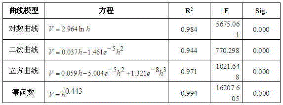
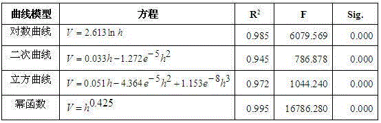
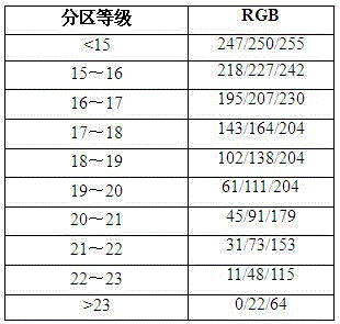
[0059] Embodiment: systematically study the meteorological background of Guizhou Province, and count the occurrence frequency of wind disasters in 88 counties and cities of the whole province, so as to obtain the distribution characteristics of wind disasters in the whole province. Formulate the basis and principles for the division of wind zones.

[0060] Climate background analysis: By analyzing the climate environment, terrain, and landforms of Guizhou Province, it is concluded that the direct cause of wind formation is the pressure gradient force. Under the influence of uplift, the wind speed increases with the increase of altitude, and the law is obvious. Moreover, due to the obvious trend of terrain changes in Guizhou, the wind speed also has a linear tendency corresponding to terrain changes. The western part of Guizhou is a high-value area, which decreases from west to east.

[0061] Summarize the characteristics of gale disasters in Guizhou: Through the statistics and...


PUM


Abstract

The invention discloses a drawing method of a power network wind zone distribution map in a mountainous area. The method comprises the steps of data acquisition, data processing, data analysis, wind zone calculation model establishment, wind zone division, wind zone distribution map drawing and the like, the distribution map which can reflect recurrence periods of instantaneous maximum wind speed of the mountainous area can be obtained finally, the route design can be guided, the design which can be applied to adjusting measures to local conditions is conducted according to the instantaneous maximum wind speed wind zone level to drain wind deflection, the project manufacturing cost is reduced, the design which can be applied to selecting the safest and economical line route and prevent wind deflection accidents when building or transformation is conducted on a transmission line can be guided, and the problem that in the prior art, the wind zone distribution map drawing method can not meet the requirements of prevention and control work of wind deflection accidents in plateau mountain areas is solved; the technical problems that in the prior art, the wind zone distribution map lacks years of proofs of data collection, statistics of acquisition and modeling comparison and lacks theoretical support are solved.

Description

technical field [0001] The invention belongs to the field of drawing wind area distribution maps of transmission lines, in particular to a method for drawing wind area distribution maps of mountainous power grids. Background technique [0002] The wind area distribution maps used in the power industry are mainly divided into two categories. One is the wind area map defined by the size of the wind energy for the development of wind power plants. The wind speed index mainly used for calculation of this type of map is the seasonal average Wind; the second type is the wind speed distribution map defined by the instantaneous maximum wind speed used to prevent "wind deviation" accidents. The wind speed index mainly used for calculation of this type of map is the maximum periodic recurrence value of wind speed for annual statistics. The distribution map of instantaneous maximum wind speed and wind area is the basis for guiding transmission lines to prevent "wind deviation" disaster...

Claims


Application Information

Patent Timeline
IPC IPC(8): G06F17/50
Inventor 黄欢彭赤毛先胤罗洪杜昊曹双和任曦犹珀玉王邦民
Owner ELECTRIC POWER SCI RES INST OF GUIZHOU POWER GRID CO LTD
Why Eureka
Try Eureka