Method for generating and using bubble data and geographic expression information system

An information system and bubble technology, applied in the field of mobile Internet, to achieve good usability, increase data value content, and reduce resource consumption

Active Publication Date: 2015-12-09
李遵白 +4
View PDF2 Cites 8 Cited by
  • Summary
  • Abstract
  • Description
  • Claims
  • Application Information

AI Technical Summary

Problems solved by technology

[0009] The purpose of the present invention is to provide a method for generating and using bubble data and a geographical complaint information system, so as to solve the aforementioned problems existing in the prior art

Method used


Image

  • Method for generating and using bubble data and geographic expression information system
  • Method for generating and using bubble data and geographic expression information system
  • Method for generating and using bubble data and geographic expression information system

Examples


Embodiment 1

[0062] An embodiment of the present invention provides a method for generating bubble data, including:

[0063] A1, define the bubble data class, and the member variables of the bubble data class follow the bubble data standard, and the foreign language name of the bubble data standard is: QiPaoDataStandard, abbreviated as: QPDS;

[0064] A2, define a construction method for the bubble data class;

[0065] A3, passing each information category into the construction method as a parameter of the construction method;

[0066] A4, complete the assignment of the parameters in the construction method;

[0067] A5, return the bubble data object;

[0068] The bubble data standard specifies the member variables of the bubble data class, including: complaining content, complaining time, complaining picture, complaining video, complaining audio, complaining geographic coordinate system and type, wherein, complaining picture, complaining video, complaining audio is optional, the others...

Embodiment 2

[0115] An embodiment of the present invention provides a method for using the bubble data generated according to the above method, including the following steps:

[0116] B1, the server stores the bubble data object in the database;

[0117] B2, receiving the client's request to read the bubble data, the server queries the bubble data object from the database, and encodes the bubble data object according to the bubble data standard;

[0118] B3, transmit the encoded bubble data object to the client, convert the bubble data object into a JSON string before transmission, and follow the JSON standard string during transmission;

[0119] B4. After the client receives the data, it decodes according to the bubble data standard to obtain the bubble data;

[0120] The client is a client in the C / S architecture, such as a mobile phone, a tablet, a wearable device, and the like.

[0121] Before B1, use the method provided in Embodiment 1 to actively or passively collect terminal devic...

Embodiment 3

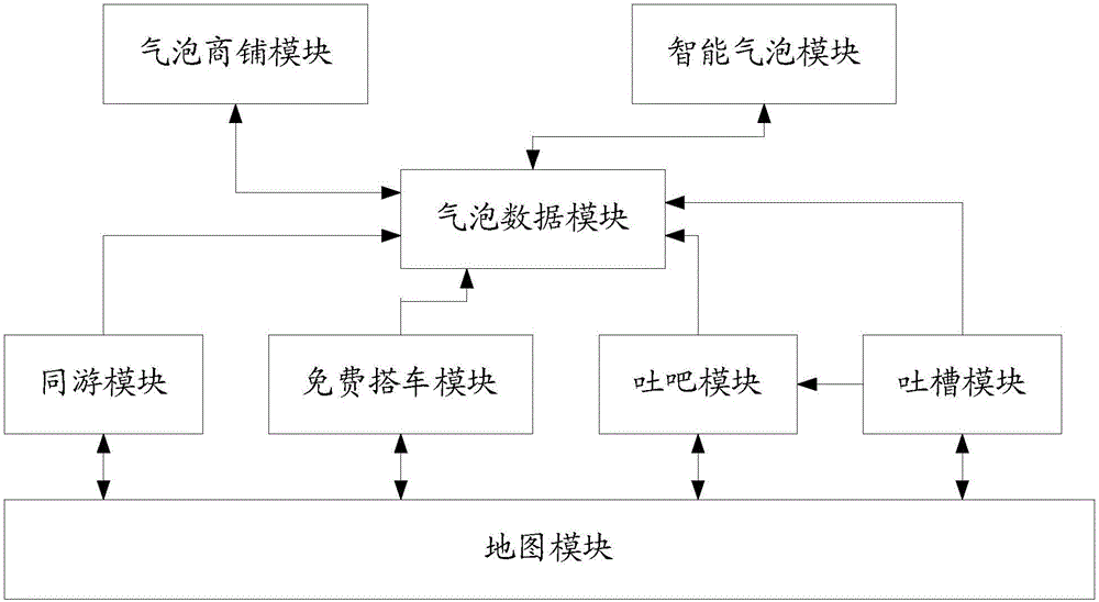
[0124] Such as figure 1 As shown, the embodiment of the present invention provides a geographic complaint information system using the bubble data provided in Embodiment 1, including:

[0125]Map module: used to obtain the user's geographical location information, and display the user's geographical location in the form of bubble data on the map, and also used to display and share the user's complaint information in the form of bubble data in the user's geographical location;

[0126] Tucao module: used to receive the user’s complaint information, process the complaint information, and return it to the user interface, and also send the user’s complaint information to the server for processing into bubble data, send it to the map module and share the user’s complaint information;

[0127] Bubble Data Module: Used to store, analyze and share bubble data.

[0128] The system described above uses GIS to make a basic blueprint of a map showing very detailed geographic location. G...


PUM


Abstract

The present invention relates to the technical field of mobile internet, in particular to a method for generating and using bubble data and a geographic expression information system. According to the technical scheme provided by embodiments of the present invention, an existing geographical information system (GIS) is combined with a user-creating-content technology, so that a user can express and share feelings and experiences anywhere and anytime, which are not limited to things in a fixed geographical location. In addition, displayed on the GIS is not only geographic information of streets, parks and the like, but also real-time expression information, i.e., the bubble data, created by the user, thereby realizing mining of user information flow and improving value content of data. The bubble data is used as a carrier to implement geographical sharing of social, business and other information. Furthermore, on-demand map positioning is carried out in a bubble manner, so that the geographical information system is low in resource consumption and high in availability.

Description

technical field [0001] The present invention relates to the technical field of mobile Internet, in particular to a method for generating and using bubble data and a geographic complaint information system. Background technique [0002] GIS (Geographic Information Systems, Geographic Information System) is the product of multiple disciplines. It is based on geographic space, adopts geographic model analysis methods, and provides a variety of spatial and dynamic geographic information in real time. It is a service for geographic research and geographic decision-making. computer technology system. [0003] The basic function of GIS is to convert tabular data (whether it comes from a database, spreadsheet file or entered directly into a program) into a geographic graphic display, and then browse, manipulate and analyze the displayed results. Its display can range from intercontinental maps to very detailed neighborhood maps, and real objects include population, sales, transport...

Claims


Application Information

Patent Timeline
Patent Type & Authority Applications(China)
IPC IPC(8): G06F17/30
CPCG06F16/9537
Inventor 李遵白陈世兴祝元民唐坤付小松
Owner 李遵白
Why Eureka
Try Eureka