Ground real-time reconstruction processing system for unmanned aerial vehicle reconnaissance images

A processing system and image preprocessing technology, applied in image data processing, image enhancement, graphics and image conversion, etc., can solve problems such as instability, reconnaissance image geometric distortion, and reconnaissance images cannot reflect the reconnaissance area, etc. Wide range of effects

Inactive Publication Date: 2015-12-09
BEIHANG UNIV
View PDF3 Cites 27 Cited by
  • Summary
  • Abstract
  • Description
  • Claims
  • Application Information

AI Technical Summary

Problems solved by technology

However, in the process of practical application, the UAV reconnaissance images have exposed the following important problems: 1) The UAV is affected by factors such as its own attitude and the instability of the imaging platform, the arbitrariness of the attitude of the imaging platform, and the scattering of atmospheric radiation. 2) Due to the influence of factors such as flying height and camera focal length of the UAV, the geographical range that can be reflected by a single reconnaissance image is relatively small. Small size, it is difficult to use one reconnaissance image to reflect all the information of the area of ​​interest; 3) Due to the limitation of the imaging principle of a single type of sensor, the reconnaissance image captured by a single sensor often cannot reflect all the detailed information of the effective target in the reconnaissance area
Due to the above defects in UAV reconnaissance images, the reconnaissance performance of UAVs is seriously affected.

Method used


Image

  • Ground real-time reconstruction processing system for unmanned aerial vehicle reconnaissance images
  • Ground real-time reconstruction processing system for unmanned aerial vehicle reconnaissance images
  • Ground real-time reconstruction processing system for unmanned aerial vehicle reconnaissance images

Examples


Embodiment Construction

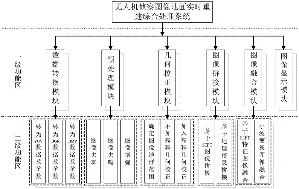
[0013] The following is a detailed introduction to each module of the UAV reconnaissance image ground real-time reconstruction comprehensive processing system combined with the accompanying drawings.

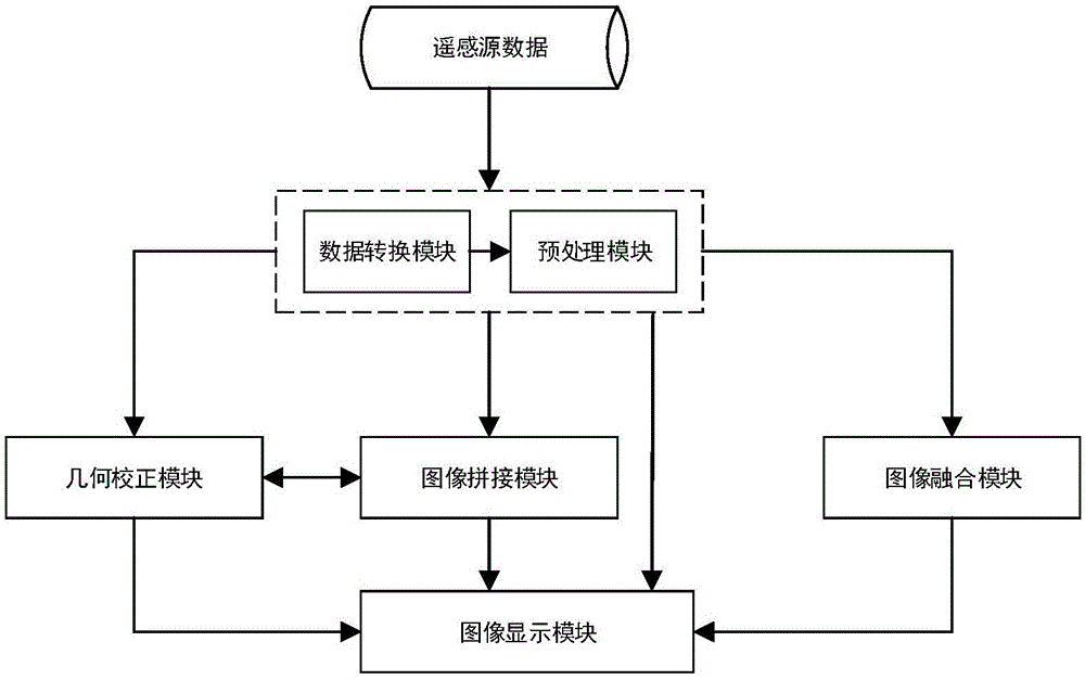
[0014] The present invention provides a ground real-time reconstruction and processing system for unmanned aerial vehicle reconnaissance images, which has a first-level functional area and a second-level functional area, such as figure 2 As shown, the system includes a data conversion module, a preprocessing module, a geometric correction module, an image stitching module, an image fusion module and an image display module, and the above modules constitute the first-level functional area of ​​the system. In the secondary functional area of ​​the system, the data conversion module can convert the image modes corresponding to different models into image (sequence) data and corresponding parameters in YUV, BGR, BMP and other formats and store them, providing a unified system for th...


PUM


Abstract

The invention discloses a ground real-time reconstruction processing system for unmanned aerial vehicle reconnaissance images, and belongs to the technical field of unmanned aerial vehicle reconnaissance image processing. The system comprises a data conversion module, an image preprocessing module, a geometric correction module, an image splicing module, an image fusion module and an image display module. The system integrates multiple unmanned aerial vehicle reconnaissance image processing functions, can meet basic requirements for reconnaissance image processing, and has a wide application range; and the system can realize real-time communication between an airborne station and a ground station by virtue of network transmission, can process image data acquired by airborne equipment in real time in the aspects of geometric correction, image splicing and the like, can perform target location quickly, and is relatively high in instantaneity.

Description

technical field [0001] The invention belongs to the technical field of unmanned aerial vehicle reconnaissance image processing, and specifically refers to a ground real-time reconstruction processing system for unmanned aerial vehicle reconnaissance images. Background technique [0002] Reconnaissance is the inherent mission of UAVs. The long-distance non-contact reconnaissance technology based on UAVs has become the main technical means of intelligence collection. Compared with satellite reconnaissance, it has its own advantages, such as low cost and reconnaissance area control. It is flexible, does not have access time and period restrictions, and has high resolution of ground targets. Compared with manned reconnaissance aircraft, it can continue to work day and night without considering factors such as pilot fatigue and casualties. Therefore, in view of the advantages of high resolution, high flexibility, high efficiency and low cost, UAVs are widely used in military and ...

Claims


Application Information

Patent Timeline
Patent Type & Authority Applications(China)
IPC IPC(8): G06T5/00G06T3/40
Inventor 丁文锐刘硕向锦武
Owner BEIHANG UNIV
Why Eureka
Try Eureka